

- Usage in publication:
-
- Everton Dolomite
- Modifications:
-
- Revised
- AAPG geologic province:
-
- Illinois basin
Summary:
Definition of Ancell Group expanded to include the Everton Dolomite in the Illinois basin. As here defined, Ancell overlies the Sauk-Tippecanoe unconformity and underlies the sub-Platteville unconformity. Everton is included in Ancell because it does not appear to be genetically related to the Knox carbonates of the Sauk sequence. Ancell, in the Illinois basin, is therefore divided into (ascending) Everton Dolomite, St. Peter Sandstone, Dutchtown Limestone, and Joachim Dolomite. Everton, Dutchtown, and Joachim are absent in northern Illinois and Wisconsin, where St. Peter Sandstone underlies the Glenwood Formation of the Ancell Group.
Source: GNU records (USGS DDS-6; Reston GNULEX).
- Usage in publication:
-
- Everton Formation
- Modifications:
-
- Areal extent
- Overview
- AAPG geologic province:
-
- Ozark uplift
- Illinois basin
Summary:
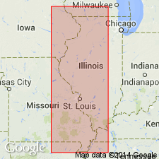
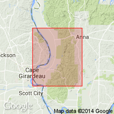
Ordovician (Champlainian) Everton Formation crops out from northwestern Perry Co., MO, to southern Cape Girardeau Co., MO. Consists of interbedded sandy dolomite and sandstone. Dolomite, typically two-thirds to three-fourths of the formation, is typically slightly to moderately cherty, light to medium gray, fine-grained, and medium to thick bedded. Fossils are poorly preserved but algal structures are common. Sandstone is white to light-gray, fine-grained quartz arenite. Also contains intermittent thin beds of gray to greenish-gray shale and a small amount of limestone near top. Thickens to the south and southeast; on outcrop, thickens from 70 ft in northern Perry Co., MO, to 380 ft in southern Cape Girardeau Co., MO. More than 400 ft thick in subsurface of IL. Lower contact is disconformable in outcrop, but may become conformable in subsurface where it is thickest.
Source: GNU records (USGS DDS-6; Reston GNULEX).
- Usage in publication:
-
- Everton Formation
- Modifications:
-
- Revised
- Overview
- AAPG geologic province:
-
- Ozark uplift
- Illinois basin
Summary:
Ordovician (Whiterockian) Everton Formation unconformably overlies Knox Group of IL or its equivalents in MO. Occurs in subsurface of MO and IL. Unconformably overlies rocks of Knox Group. In Humble Oil Co. No. 1 Pickel well, NW1/4SE1/4NW1/4 sec. 21, T13S, R2W, Mill Creek 7.5-min quad, IL, Everton consists of 240 ft of light- to medium-brown, micritc to coarsely crystalline, sandy dolomite. Thickness is 56 to 106 ft according to sample logs for two deep wells in Pulaski Co., IL, 8 to 10 mi to the southeast. Thickens southeastward from 70 ft in Perry Co., MO, to more than 400 ft in subsurface of southeastern IL.
Source: GNU records (USGS DDS-6; Reston GNULEX).

- Usage in publication:
-
- Everton Formation*
- Modifications:
-
- Revised
- Areal extent
- AAPG geologic province:
-
- Illinois basin
- Ozark uplift
- Upper Mississippi embayment
Summary:
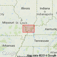
Ordovician (Whiterockian) Everton Formation is assigned to top of Knox Group in IL and KY. Crops out along a belt from northwestern Perry Co, MO, to northwestern Scott Co., MO. Occurs in subsurface in southern IL and western KY.
Source: GNU records (USGS DDS-6; Reston GNULEX).

- Usage in publication:
-
- Everton Formation*
- Modifications:
-
- Overview
- AAPG geologic province:
-
- Illinois basin
- Upper Mississippi embayment
Summary:
Middle Ordovician (Whiterockian) Everton Formation mapped undivided with St. Peter Sandstone in subsurface of Upper Mississippi embayment of IL and MO.
Source: GNU records (USGS DDS-6; Reston GNULEX).
For more information, please contact Nancy Stamm, Geologic Names Committee Secretary.
Asterisk (*) indicates published by U.S. Geological Survey authors.
"No current usage" (†) implies that a name has been abandoned or has fallen into disuse. Former usage and, if known, replacement name given in parentheses ( ).
Slash (/) indicates name conflicts with nomenclatural guidelines (CSN, 1933; ACSN, 1961, 1970; NACSN, 1983, 2005, 2021). May be explained within brackets ([ ]).