The National Geologic Map Database is migrating to a new infrastructure. We apologize for any service disruptions during this process.
|
|---|


- Usage in publication:
-
- Evanston group
- Modifications:
-
- Original reference
- AAPG geologic province:
-
- Green River basin
Lesquereux, Leo, 1876, A review of the fossil flora of North America: U.S. Geological and Geographical Survey of the Territories (Hayden), Bulletin, 1, no. 5, 2nd ser., p. 233-248.
Summary:
Pg. 244-248. Evanston group (upper Eocene or lower Miocene) may represent merely an upper member of Lower Lignitic (Eocene), which it overlies. Separated from Green River group (upper Miocene) by Carbon group (middle Miocene). [Latter name doubtless applies to Wasatch group, Eocene.]
Source: US geologic names lexicon (USGS Bull. 896, p. 709).
- Usage in publication:
-
- Evanston coal series
- Modifications:
-
- Areal extent
- AAPG geologic province:
-
- Green River basin
White, C.A., 1879, Report on the paleontological field work for the season of 1877: U.S. Geological and Geographical Survey of the Territories (Hayden), Annual Report, 11, p. 159-272.
Summary:
Pg. 240-241. Evanston coal series underlies Wasatch and overlies Bear River. [Age is Eocene or Late Cretaceous.]
Source: US geologic names lexicon (USGS Bull. 896, p. 709).
- Usage in publication:
-
- Evanston formation
- Modifications:
-
- [Principal reference]
- Dominant lithology:
-
- Clay
- Sandstone
- Coal
- AAPG geologic province:
-
- Central Western Overthrust
- Green River basin
Summary:
Pg. 332. Evanston formation. Gray and yellow clays, with irregular sandstone beds containing Almy coal and several minor coal beds. Characterized by plants which are distinctive of upper Laramie beds, and by invertebrates which are common to the Laramie and Fort Union. Thickness 1,500 feet. Of Eocene or Upper Cretaceous age. Underlies Wasatch and rests on Bear River and Jurassic beds. The coal mined at Evanston is in this formation. Is same as "Evanston coal series" of C.A. White, 1879.
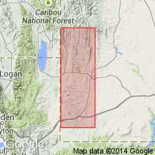
Exposed from Evanston for 10 mi north [Uinta Co.], southwestern WY.
Source: US geologic names lexicon (USGS Bull. 896, p. 709).
- Usage in publication:
-
- Evanston formation*
- Modifications:
-
- [Principal reference]
- AAPG geologic province:
-
- Green River basin
Summary:
Gave thickness of Evanston formation ("Upper Laramie") as 1,600+/- feet and stated that it rests on Bear River and Beckwith formations. [Age is Eocene or Late Cretaceous.]
[Includes measured sections of typical Evanston.]
Source: Publication; US geologic names lexicon (USGS Bull. 896, p. 709).
- Usage in publication:
-
- Evanston formation
- Modifications:
-
- Age modified, tentatively
- AAPG geologic province:
-
- Green River basin
Summary:
Pg. 19, pl. 1. Evanston formation. Tentatively called Paleocene (Puercan); underlies Almy formation.
Source: US geologic names lexicon (USGS Bull. 1200, p. 1300).
- Usage in publication:
-
- Evanston formation
- Modifications:
-
- Areal extent
- AAPG geologic province:
-
- Central Western Overthrust
Summary:
Pg. 126-128. Evanston formation. Veatch (USGS Prof. Paper 56, 1907) showed formation limited to three small areas near Evanston. Present mapping shows fairly wide distribution of rocks lithologically and temporally equivalent to the Evanston within Fossil basin. On east side of basin, unit may be traced for great distances where boulder beds dip 25 to 30 degrees to west and form hogbacks. Along this belt, mapped as Almy formation by Veatch, the Evanston conformably overlies Adaville formation, but north of Kemmerer the boulder beds truncate large syncline in the Adaville. Thickness ranges widely due to lack of uniformity in deposition and to subsequent erosion; 1,200 feet near southern boundary of Kemmerer quadrangle, uppermost several hundred feet not present. Contact with overlying Wasatch formation poorly exposed; apparently gradational at type locality, but angular unconformity present at many places. Latest Cretaceous and Paleocene. Formation is significant because of its relation to structural framework of basin; it indicates that principal period of formation of basin extended from latest Cretaceous (Lance) through Paleocene; also dates at least part of orogeny in thrust belt as Late Cretaceous.
Source: US geologic names lexicon (USGS Bull. 1200, p. 1300).
- Usage in publication:
-
- Evanston Formation*
- Modifications:
-
- Revised
- AAPG geologic province:
-
- Green River basin
Summary:
Pg. 5-14. Evanston Formation. Divided into (ascending): (1) unnamed lower member, gray to very dark-gray mudstone, siltstone, claystone, and gray carbonaceous sandstone, thickness up to 500 feet, Upper Cretaceous; (2) Hams Fork Conglomerate Member (new), thickness 455 feet in outcrop and about 1,000 feet in subsurface, Upper Cretaceous; and (3) main body, light- to dark-gray carbonaceous sandy to clayey siltstone interbedded with gray, tan, yellow, and brown sandstone and conglomerate and carbonaceous to lignitic claystone, thickness 250+ feet in outcrop and about 1,355 feet in subsurface, Upper Cretaceous and Paleocene. Total thickness 2,000+ feet. Lies below Wasatch Formation and above Adaville Formation. Fossils. [Listed; see also Rubey and others, 1961, Age of Evanston Formation, USGS Prof. Paper 424-B, Art. 64, p. B153-B154.]
Source: Publication.
- Usage in publication:
-
- Evanston Formation*
- Modifications:
-
- Areal extent
- AAPG geologic province:
-
- Wasatch uplift
- Uinta uplift
Summary:
Name extended to lower Echo Canyon, Summit Co, UT on Uinta uplift, and to lower Lost Creek and East Canyon Reservoir, Morgan Co, UT on Wasatch uplift. Twofold division described. First, basal conglomerate which may be equivalent to Hams Fork Conglomerate Member of the Evanston in WY contains quartzite cobbles and small boulders derived from the Farmington Canyon Complex, minor amount of carbonate cobbles and pebbles from Cambrian and Precambrian rocks in a matrix of rounded to angular quartz and dark gray chert grains. Chert derived from upper Paleozoic carbonate units. Thins from west to east. Is reddish-brown in west exposures and gray-yellow in east exposures. Second, upper fine-grained part is 1,000 ft thick, forms ledgy slopes and is composed of interbedded conglomeratic grit, gray, silty, micaceous sandstone, gray mudstone, minor amount of quartzite conglomerate, carbonaceous shale, and coal. Cannot be separated from generally overlying Wasatch Formation at all localities. Overlies with angular discordance the Echo Canyon Conglomerate. Rocks called Evanston in this paper have been variously assigned to Saw Mill Conglomerate, Fowkes Formation, part of Almy and part of Knight Formation. Late Cretaceous and Paleocene age. Pollen of Lance age identified. Nomenclature chart. Willard fault ceased before deposition of Upper Cretaceous.
Source: GNU records (USGS DDS-6; Denver GNULEX).
- Usage in publication:
-
- Evanston Formation*
- Modifications:
-
- Biostratigraphic dating
- AAPG geologic province:
-
- Wasatch uplift
- Uinta uplift
- Green River basin
Summary:
Evanston is divisible into a main body (Paleocene, Upper Cretaceous), Hams Fork Conglomerate Member (Upper Cretaceous), and lower member (Upper Cretaceous). Palynological studies indicate a distinct difference in age exists between the main body and the Hams Fork. The main body has yielded palynomorphs that give a middle to late Paleocene age. The Hams Fork has assemblages of late Campanian-Maastrichtian AQUILAPOLLENITES QUADRILOBUS Interval Zone. A 4 to as much as 6 m.y. may separate Hams Fork from the underlying lower member. The AQUILAPOLLENITES SENONICUS Interval Zone is absent in southwest WY and northeast UT thrust belt. This zone represents that missing time. Palynomorphs were collected from the Evanston in Lincoln and Uinta Cos, WY in the Greater Green River basin; in Summit Co, UT on the Uinta uplift; and in Morgan and Rich Cos, UT on the Wasatch uplift.
Source: GNU records (USGS DDS-6; Denver GNULEX).
For more information, please contact Nancy Stamm, Geologic Names Committee Secretary.
Asterisk (*) indicates published by U.S. Geological Survey authors.
"No current usage" (†) implies that a name has been abandoned or has fallen into disuse. Former usage and, if known, replacement name given in parentheses ( ).
Slash (/) indicates name conflicts with nomenclatural guidelines (CSN, 1933; ACSN, 1961, 1970; NACSN, 1983, 2005, 2021). May be explained within brackets ([ ]).