

- Usage in publication:
-
- Eureka rhyolite*
- Modifications:
-
- Original reference
- Dominant lithology:
-
- Rhyolite
- AAPG geologic province:
-
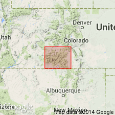
- San Juan Mountains province
Summary:
Eureka quartzite of Silverton volcanic series. Massive flows, dikes, and well-bedded tuffs, former greatly predominating. Much of rock can be called a flow breccia. Thickness thin to 2,000 feet. Unconformably underlies Burns latite complex and unconformably overlies Picayune andesite. Age is late Tertiary (Miocene).
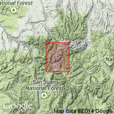
[Mapped around town of Eureka, Silverton quadrangle, southwestern CO.]
Source: US geologic names lexicon (USGS Bull. 896, p. 707).
- Usage in publication:
-
- Eureka rhyolite*
- Modifications:
-
- Areal extent
- AAPG geologic province:
-
- San Juan Mountains province
Summary:
Pg. 14, 77-78. Eureka rhyolite. Mainly in flows or welded tuffs. Maximum observed thickness near Eureka Gulch of 2,000 feet, thins out to west, north, and east. Typical exposure and geographical extent cited.
Greatest and most typical exposure in steep walls of Animas Valley at and above Eureka Gulch. Widely distributed in Silverton quadrangle and extends eastward down Henson Creek as far as Lake City and for a few mi into San Cristobal quadrangle, southwestern CO.
[GNC remark (ca. 1960, US geologic names lexicon, USGS Bull. 1200, p. 1297): The USGS currently classifies the Eureka Tuff as a formation in the Silverton Volcanic Group and designates the age as middle and late Tertiary on the basis of a study now in progress. (See Leudke and Burbank, 1963.)]
Source: US geologic names lexicon (USGS Bull. 1200, p. 1297).
- Usage in publication:
-
- Eureka Tuff*
- Modifications:
-
- Redescribed
- Age modified
- Dominant lithology:
-
- Tuff
- AAPG geologic province:
-
- San Juan Mountains province
Summary:
Redescribed from Eureka Rhyolite to Eureka Tuff. Is restricted to a succession of even-bedded rhyodacitic to rhyolitic welded ash-flow tuffs. May be as much as 1,000 ft thick. Is younger than Picayune Formation (formerly Picayune Quartz Latite); is older than Burns Formation (formerly Burns Latite). Is one of four formations assigned to Silverton Volcanic Group (formerly Silverton Volcanic Series). Assigned to the middle and late Tertiary in San Juan Mountain province.
Source: GNU records (USGS DDS-6; Denver GNULEX).
- Usage in publication:
-
- Eureka Member*
- Modifications:
-
- Revised
- AAPG geologic province:
-
- San Juan Mountains province
Summary:
Reduced in stratigraphic rank from Eureka Tuff of Silverton Volcanic Group (abandoned) to Eureka Member of Sapinero Mesa Tuff. Is recognized as the intracaldera accumulation of the outflow Sapinero Mesa Tuff in the San Juan Mountain province. Is at least 700 m thick in places. Oligocene age.
Source: GNU records (USGS DDS-6; Denver GNULEX).
For more information, please contact Nancy Stamm, Geologic Names Committee Secretary.
Asterisk (*) indicates published by U.S. Geological Survey authors.
"No current usage" (†) implies that a name has been abandoned or has fallen into disuse. Former usage and, if known, replacement name given in parentheses ( ).
Slash (/) indicates name conflicts with nomenclatural guidelines (CSN, 1933; ACSN, 1961, 1970; NACSN, 1983, 2005, 2021). May be explained within brackets ([ ]).