

- Usage in publication:
-
- Elm Point formation
- Modifications:
-
- Contact revised
- AAPG geologic province:
-
- Williston basin
Summary:
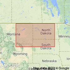
Lower contact revised in that Elm Point unconformably overlies the newly named Silurian or Devonian Ashern formation. Both Ashern and Elm Point are newly assigned to the Elk Point group (rank raised). Dolostone assigned to Ashern in this report was formerly included as part of the Silurian Stonewall formation. Elm Point mapped along east shore of Lake Manitoba, Manitoba, CN in the Williston basin. Section 43+ ft thick measured in the Canada Cement Co. Ltd. quarry in NW1/4 sec 34, T28, R10W. Brachiopod fossils. Assigned to the Middle Devonian. Cross sections; well log descriptions; correlation chart.
Source: GNU records (USGS DDS-6; Denver GNULEX).
- Usage in publication:
-
- Elm Point Group
- Modifications:
-
- Contact revised
- AAPG geologic province:
-
- Williston basin
Summary:
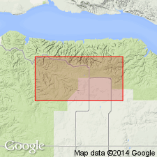
Lower contact revised in the subsurface of central Williston basin, ND in that Ashern Formation, basal formation of Elm Point Group, overlies the newly named Sherven Formation, upper formation of Interlake Group (rank raised). Interlake-Elm Point boundary probably marked by significant erosional period. Age of Ashern given as Late Silurian, Early and Middle Devonian. [Range of age of Elm Point Group not discussed.]
Source: GNU records (USGS DDS-6; Denver GNULEX).
For more information, please contact Nancy Stamm, Geologic Names Committee Secretary.
Asterisk (*) indicates published by U.S. Geological Survey authors.
"No current usage" (†) implies that a name has been abandoned or has fallen into disuse. Former usage and, if known, replacement name given in parentheses ( ).
Slash (/) indicates name conflicts with nomenclatural guidelines (CSN, 1933; ACSN, 1961, 1970; NACSN, 1983, 2005, 2021). May be explained within brackets ([ ]).