The National Geologic Map Database is migrating to a new infrastructure. We apologize for any service disruptions during this process.
|
|---|


- Usage in publication:
-
- El Vado Sandstone Member*
- Modifications:
-
- Named
- Dominant lithology:
-
- Sandstone
- Siltstone
- Shale
- AAPG geologic province:
-
- San Juan basin
Summary:
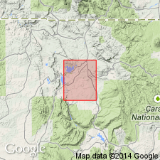
Named as a member of Mancos Shale for outcrops west of El Vado Reservoir, Boulder Lake quad, Rio Arriba Co, NM, San Juan basin. Type section measured below 7,388 ft elevation point located 2.4 mi east and 1 mi north of southwest corner of Tierra Amarilla Grant and about 2 mi southwest of emergency outflow outlet for El Vado Reservoir. Ranges from 90 to 100 ft thick. Is 99 ft 10 in thick at type where it overlies middle shale unit and underlies upper shale unit of Mancos. Composed of gray shaly siltstone and silty shale, very fine grained, thin-bedded, calcareous, brownish-gray sandstone. Sandstone is minutely micaceous, has oyster fragments, and some beds are cross-bedded. Crops out extensively in eastern part of quad. Some ripple bedding, fish remains, trail marks. Contains plates of INOCERAMUS PLATINUS encrusted with OSTREA CONGESTA. Of Late Cretaceous age.
Source: GNU records (USGS DDS-6; Denver GNULEX).
- Usage in publication:
-
- El Vado Sandstone Member*
- Modifications:
-
- Areal extent
- Reference
- AAPG geologic province:
-
- San Juan basin
Summary:
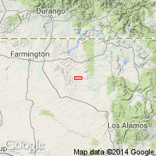
As a member of Mancos Shale extended west from type section into subsurface of San Juan basin. Reference well designated as Caulkins Oil Co. No. 140 Breech D, NE NE sec 11, T26N, R6W, Rio Arriba Co, NM.
Source: GNU records (USGS DDS-6; Denver GNULEX).
For more information, please contact Nancy Stamm, Geologic Names Committee Secretary.
Asterisk (*) indicates published by U.S. Geological Survey authors.
"No current usage" (†) implies that a name has been abandoned or has fallen into disuse. Former usage and, if known, replacement name given in parentheses ( ).
Slash (/) indicates name conflicts with nomenclatural guidelines (CSN, 1933; ACSN, 1961, 1970; NACSN, 1983, 2005, 2021). May be explained within brackets ([ ]).