The National Geologic Map Database is migrating to a new infrastructure. We apologize for any service disruptions during this process.
|
|---|


- Usage in publication:
-
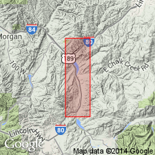
- Echo Canyon conglomerate
- Modifications:
-
- First used
- Dominant lithology:
-
- Sandstone
- Conglomerate
- AAPG geologic province:
-
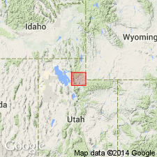
- Uinta uplift
Summary:
Named for sequence of red conglomerates, sandstones, and shaly sandstones exposed in lower part of Echo Canyon and adjacent areas, Summit Co, UT on the Uinta uplift. No type locality designated. Overlies Wanship Formation. Unconformably underlies Knight Formation. Is 3,100 ft thick in Echo Junction area. Previously called Tertiary conglomerates. Previously correlated with Almy Formation. Fossils found 400 ft above base are of late? Niobrara age. Upper part probably Montanan age. Late Cretaceous. Graphic columnar section.
Source: GNU records (USGS DDS-6; Denver GNULEX).
- Usage in publication:
-
- Echo Canyon Conglomerate*
- Modifications:
-
- Overview
- Dominant lithology:
-
- Conglomerate
- AAPG geologic province:
-
- Uinta uplift
- Wasatch uplift
Summary:
No type designated by original authors so exposures in secs 18, 19, and 30, T3N, R5E, Summit Co, UT on the Uinta uplift designated the type section [principal reference section]. Extends into Morgan and Salt Lake Cos, UT on the Wasatch uplift. Overlies Wanship Formation. Underlies Evanston Formation. Is 1,400 ft thick near Croyden and 1,500+ ft thick near East Canyon Reservoir. Thickness at type not stated. Is a red-brown, cliff-former consisting mainly of conglomerate of pebble to small boulder-size clasts of subangular to rounded fragments of carbonate rock, sandstone, and siltstone, and of cobbles and boulders of pink quartzite, and a few of purple to green quartzite. Clasts from younger rocks common at base. Clasts from older rocks common at top. Westward, the Echo Canyon is cobble to boulder conglomerate with few beds of fine material. Includes some sandstone and mudstone. Fossils (INOCERAMUS, brackish-water mollusks). Probably deposited several mi west of westernmost exposures. Is an organic conglomerate. Is equivalent to Almy Conglomerate. Not identified north of Croyden. Of Late Cretaceous age. Correlation chart. Geologic map.
Source: GNU records (USGS DDS-6; Denver GNULEX).
- Usage in publication:
-
- Echo Canyon Conglomerate*
- Modifications:
-
- Biostratigraphic dating
- AAPG geologic province:
-
- Uinta uplift
Summary:
Palynomorph assemblages collected from the Echo Canyon Conglomerate in Summit Co, UT on the Uinta uplift yielded an age of Coniacian-Santonian. Fine-grained beds within the formation had the assemblages of nonmarine palynomorphs. Correlated with lower to middle parts of Hilliard Shale. Unconformably overlies Henefer Formation of Coniacian age. Unconformably underlies Hams Fork Conglomerate Member of Evanston Formation of late Campanian-Maastrichtian age.
Source: GNU records (USGS DDS-6; Denver GNULEX).
- Usage in publication:
-
- Echo Canyon Conglomerate
- Modifications:
-
- Overview
- AAPG geologic province:
-
- Wasatch uplift
Summary:
Is a coarse alluvial-fan conglomerate more than 520 m thick that contains abundant clasts of white, gray, and tan quartzite. Crops out 60 km south of the Crawford thrust, northeast UT on the Wasatch uplift. Paleocurrent data indicate dispersal eastward. The only major source of quartzite was thought to be on the hanging wall of the Crawford thrust to be the Pennsylvanian Wells Formation. Quartzite and pebbly quartzite clasts derived from the Cambrian Tintic Formation and older Proterozoic formations are abundant in the lower part of the Echo Canyon. Since no Proterozoic rocks are known to be carried in the Crawford sheet, the Echo Canyon must have been derived from another source. The alternate source is the Willard thrust sheet. Lithologic provenance modeling, paleocurrent data, and regional structural relations suggest derivation of the conglomerate from three separate areas on the Willard thrust sheet and eastern flank of the Wasatch culmination. Age has been firmly established as Coniacian-Santonian.
Source: GNU records (USGS DDS-6; Denver GNULEX).
- Usage in publication:
-
- Echo Canyon Conglomerate*
- Modifications:
-
- Biostratigraphic dating
- Mapped 1:100k
- Dominant lithology:
-
- Conglomerate
- Sandstone
- AAPG geologic province:
-
- Uinta uplift
- Wasatch uplift
Summary:
Is Upper Cretaceous formation mapped in southeast Morgan Co, UT (Wasatch uplift) and in Summit Co, UT (Uinta uplift) in northern part of map area. Overlies Henefer Formation (Upper Cretaceous). Is overlain by Hams Fork Member of Evanston Formation (Upper Cretaceous). Map unit described as pale-red to yellowish-gray to light-yellowish-brown cobble conglomerate containing discontinuous lenses of coarse-grained sandstone. Contains very sparse intervals of gray sandstone, siltstone, and claystone, some of which contain pollen of Coniacian to Santonian age. Clasts in conglomerate are predominantly sandstone derived from Mesozoic or upper Paleozoic rocks. Limestone and chert clasts are sparse. On northwest side of East Canyon graben, unit contains angular to subrounded fragments of Paleozoic limestone and upper Paleozoic and Mesozoic sandstone. Boulders are as much as 3 m in diameter in lower part. Thickness about 800 m. Palynomorphs recovered from four samples about 250 m above base of unit in sec 30, T3N, R5E, Summit Co, UT. All samples assigned to the PROTEACIDITES RETUSUS palynostratigraphic zone (Coniacian-Santonian).
Source: GNU records (USGS DDS-6; Denver GNULEX).
For more information, please contact Nancy Stamm, Geologic Names Committee Secretary.
Asterisk (*) indicates published by U.S. Geological Survey authors.
"No current usage" (†) implies that a name has been abandoned or has fallen into disuse. Former usage and, if known, replacement name given in parentheses ( ).
Slash (/) indicates name conflicts with nomenclatural guidelines (CSN, 1933; ACSN, 1961, 1970; NACSN, 1983, 2005, 2021). May be explained within brackets ([ ]).