

- Usage in publication:
-
- Eau Claire [sandstone]
- Modifications:
-
- Original reference
- Dominant lithology:
-
- Sandstone
- AAPG geologic province:
-
- Wisconsin arch
Summary:
Pg. 354. Eau Claire [sandstone]. (Ulrich mss. 1914). Mostly thin-bedded, in part shaly sandstone, with many fossiliferous layers, including Owen's Menominee trilobite zone and Wooster's Eau Claire trilobite zone. Usually a coarse white friable sandstone with DICELLOMUS and LINGULELLA at base. Numerous characteristic Upper Cambrian trilobites, CREPICEPHALUS IOWENSIS being one of best guide fossils. Thickness about 100 feet. Underlies Dresbach sandstone and overlies Mount Simon sandstone. Age is Late Cambrian.
[Named from exposures at mouth of Eau Claire River, near city of Eau Claire, Eau Claire Co., western WI.]
Source: US geologic names lexicon (USGS Bull. 896, p. 657-658).
- Usage in publication:
-
- Eau Claire shale
- Modifications:
-
- Overview
- AAPG geologic province:
-
- Wisconsin arch
Summary:
Pg. 71-93. Eau Claire shale, 200 to 350 feet thick, underlies Desbach sandstone and overlies Mount Simon sandstone in Wisconsin. Age is Late Cambrian.
Source: US geologic names lexicon (USGS Bull. 896, p. 657-658).
- Usage in publication:
-
- Eau Claire member
- Modifications:
-
- Revised
- AAPG geologic province:
-
- Wisconsin arch
Summary:
Eau Claire member of Dresbach formation. Treated these beds as a member of their Dresbach formation. Age is Late Cambrian.
[See 1934 and 1935 entries under Dresbach sandstone.]
Source: US geologic names lexicon (USGS Bull. 896, p. 657-658).
- Usage in publication:
-
- Eau Claire member
- Modifications:
-
- Revised
- AAPG geologic province:
-
- Wisconsin arch
Summary:
Pg. 1690, 1694. Eau Claire member of Dresbach formation. Middle member of Dresbach formation. Underlies Galesville member [Dresbach sandstone of many authors and reports] and overlies Mount Simon member. Divided, on basis of fossils, into CREPICEPHATUS zone (above), 75 feet thick, and CEDARIA zone (below), 50 feet thick. Coincides with "Eau Claire trilobite beds" of Wooster. Age is Late Cambrian.
Source: US geologic names lexicon (USGS Bull. 896, p. 657-658).

- Usage in publication:
-
- Eau Claire sandstone*
- Modifications:
-
- Overview
- AAPG geologic province:
-
- Wisconsin arch
Summary:
Eau Claire sandstone. The USGS at present [ca. 1936] treats the Eau Claire as a distinct formation, underlying Desbach sandstone [Galesville member of some authors] and overlying Mount Simon sandstone. Age is Late Cambrian.
Named from exposures at mouth of Eau Claire River, near city of Eau Claire, Eau Claire Co., western WI.
Source: US geologic names lexicon (USGS Bull. 896, p. 657-658).
- Usage in publication:
-
- Eau Claire member
- Modifications:
-
- Areal extent
- AAPG geologic province:
-
- Iowa shelf
Summary:
Pg. 30, 32, 33, measured sections. Eau Claire member of Dresbach formation. Middle member of Dresbach formation. Commonly medium- to fine-grained gray to buff sandstone with beds and partings of gray shale; may include conglomerates, and over large areas its shales may be red. Thickness about 128 feet at type section of Dresbach. Overlies Mount Simon member; underlies Galesville member. Present in southeastern Minnesota. Age is Late Cambrian.
Source: US geologic names lexicon (USGS Bull. 1200, p. 1209).
- Usage in publication:
-
- Eau Claire sandstone*
- Modifications:
-
- Overview
- AAPG geologic province:
-
- Wisconsin arch
- Iowa shelf
Summary:
Pg. 255 (fig. 32), 371. Eau Claire sandstone. Referred to as Eau Claire sandstone. Overlies Mount Simon sandstone; underlies Dresbach sandstone. Thickness 70 to 330 feet. Age is Late Cambrian.
Source: US geologic names lexicon (USGS Bull. 1200, p. 1209).

- Usage in publication:
-
- Eau Claire sandstone*
- Modifications:
-
- Overview
- AAPG geologic province:
-
- Wisconsin arch
- Iowa shelf
Summary:
Eau Claire sandstone. USGS currently [ca. 1960] includes the Eau Claire sandstone in the Dresbach group. Present in western Wisconsin and southeastern Minnesota. Age is Late Cambrian.
Source: US geologic names lexicon (USGS Bull. 1200, p. 1209).
- Usage in publication:
-
- Eau Claire Formation
- Modifications:
-
- Revised
- AAPG geologic province:
-
- Michigan basin
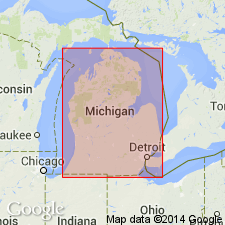
Summary:
Munising retained at Formation rank north of line shown in fig. 8. In Upper Peninsula includes Miners Castle Sandstone and Chapel Rock Sandstone Members. In Lower Peninsula Munising raised to Group rank and includes Franconia Formation, Galesville Sandstone, and Eau Claire Formations.
Source: GNU records (USGS DDS-6; Reston GNULEX).
- Usage in publication:
-
- Eau Claire Member
- Modifications:
-
- Revised
- AAPG geologic province:
-
- Michigan basin
Summary:
In the subsurface of MI, the Munising Formation of the Lake Superior Group includes (descending) the Franconia Sandstone Member, the Dresbach Sandstone Member, the Eau Claire Member, and the Mount Simon Sandstone Member. Unit underlies the Trempealeau Formation of the Lake Superior Group and overlies the Jacobsville Sandstone. Age is Late Cambrian.
Source: GNU records (USGS DDS-6; Reston GNULEX).

- Usage in publication:
-
- Eau Claire Formation
- Modifications:
-
- Areal extent
- Revised
- AAPG geologic province:
-
- Michigan basin
Summary:
Munising extended to IN as Group within Potsdam Supergroup. In northwest IN, consists of the Franconia Formation (top), the Ironton Sandstone, the Galesville Sandstone, and the Eau Claire Formation. Unit includes only the Eau Claire in southwest IN, and only the Davis Formation (top) and the Eau Claire throughout most of the state. Underlies Potosi Dolomite and overlies Mount Simon Sandstone.
Source: GNU records (USGS DDS-6; Reston GNULEX).
- Usage in publication:
-
- Eau Claire Formation
- Modifications:
-
- Overview
- AAPG geologic province:
-
- Wisconsin arch
Summary:
Eau Claire Formation of Elk Mound Group thins eastward onto the Wisconsin arch. Recognition difficult in south-central WI. Too thin in northeastern Sauk Co. to show on Plate 1 and so is mapped here with Wonewoc Formation. Known from drillhole cores in southeastern part of county. Unit that authors call Eau Claire in northeastern Sauk Co. consists of a few meters of reddish brown sandstone composed of very fine to coarse sand with some siltstone layers that are typically no more than a few mm thick. Coarser grains are primarily quartz and rounded. Characterized by thin flaggy bedding, commonly bioturbated and thin, dark reddish-brown layers, which consist of iron-oxide-cemented sandstone and cut across bedding. Poorly preserved fossil fragments present. Upper contact with Wonewoc not exposed; gradationally(?) overlies Mount Simon Formation. Unit probably 1 to 3 m thick in many parts of northeastern Sauk Co. Well logs in southeastern Sauk Co. indicate unit is between 50 and 100 m thick and consists of dolomitic sandstone composed of quartzose, very fine to medium sand with considerable dolomitic siltstone, dolomitic shale, and sandy dolomite. This strata referred to Eau Claire because they are roughly in the middle of the Elk Mound Group and because they resemble the Eau Claire of western WI.
Source: GNU records (USGS DDS-6; Reston GNULEX).
- Usage in publication:
-
- Eau Claire Formation
- Modifications:
-
- Overview
- AAPG geologic province:
-
- Michigan basin
Summary:
In the southern peninsula of MI, Eau Claire, Galesville, and Franconia Formations are collectively referred to the Munising Group because of their genetic relations. In the northern peninsula, Munising is retained at formation rank. This nomenclature follows Catacosinos (1973, 1974).
Source: GNU records (USGS DDS-6; Reston GNULEX).
- Usage in publication:
-
- Eau Claire Formation*
- Modifications:
-
- Areal extent
- AAPG geologic province:
-
- Appalachian basin
Summary:
Geographically extended the Eau Claire Formation into the subsurface of KY in the Cincinnati Arch as shown in section G-G'. Overlies the Mount Simon Sandstone and underlies the Knox Group. Unit correlates with the Conasauga Formation in the Waverly Arch and Ohio-West Virginia hinge zone of KY. The Eau Claire is of Late Cambrian age.
Source: GNU records (USGS DDS-6; Reston GNULEX).
- Usage in publication:
-
- Eau Claire Formation*
- Modifications:
-
- Overview
- AAPG geologic province:
-
- Illinois basin
Summary:
Late Cambrian (Croixan) Eau Claire Formation consists of thin-bedded, shaly, fossiliferous sandstone overlying Mount Simon Sandstone in subsurface of IL and KY. Its facies equivalent, the Bonneterre Formation, consists of limestone and dolomite overlying Lamotte Sandstone on Ozark dome in MO.
Source: GNU records (USGS DDS-6; Reston GNULEX).
For more information, please contact Nancy Stamm, Geologic Names Committee Secretary.
Asterisk (*) indicates published by U.S. Geological Survey authors.
"No current usage" (†) implies that a name has been abandoned or has fallen into disuse. Former usage and, if known, replacement name given in parentheses ( ).
Slash (/) indicates name conflicts with nomenclatural guidelines (CSN, 1933; ACSN, 1961, 1970; NACSN, 1983, 2005, 2021). May be explained within brackets ([ ]).