The National Geologic Map Database is migrating to a new infrastructure. We apologize for any service disruptions during this process.
|
|---|


- Usage in publication:
-
- Dutch Peak tillite
- Modifications:
-
- Areal extent
- AAPG geologic province:
-
- Southern Rocky Mountain region
Summary:
Pg. 37. Dutch Peak tillite of Sheeprock series. Gradational character of upper and lower contacts and interfingering of tillite with quartzites and phyllites of Sheeprock series indicates that Dutch Peak is conformably included between strata represented by hiatuses above and below Mineral Fork tillite of Wasatch Range, western Utah. [Age is Precambrian.]
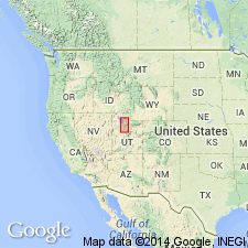
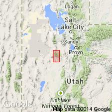
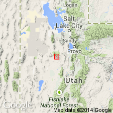
Crops out from head of South Oak Brush Canyon along crest of Sheeprock Mountains to Dutch Peak where it leaves divide and forms dip slope along north-facing slopes to Little Valley Creek. Present north of principal mining area in West Tintic mining district, western UT.
Source: Publication; US geologic names lexicon (USGS Bull. 1200, p. 1188).
- Usage in publication:
-
- Dutch Peak tillite
- Modifications:
-
- Original reference
- Dominant lithology:
-
- Tillite
- AAPG geologic province:
-
- Southern Rocky Mountain region
- Great Basin province
Summary:
Pg. 19-25, 28, 131-133, 135, pls. 1, 3. Dutch Peak tillite of Sheeprock series. Name proposed for tillite in middle part of Sheeprock series (new). Typically dark-green conglomeratic rock having a slate of quartzite matrix. Is a slope former. Thickness 4,044 feet on Dutch Peak; 2,555 feet in Pole Canyon. Probable that it is in part equivalent in age to the Mineral Fork tillite of Wasatch Mountains. Age is Precambrian.
Type section: in Precambrian section (PC-3) from Dutch Peak [Lat. 39 deg. 57 min. 18 sec. N., Long. 112 deg. 28 min. 50 sec. W.] north to right hand fork of Dutch Creek, in secs. 12, 13, and 14 [unsurveyed], T. 10 S., R. 6 W., [Dutch Peak 7.5-min quadrangle], Tooele Co., Wasatch National Forest, western UT. Crops out from head of South Oak Brush Canyon along crest of Sheeprock Mountains to Dutch Peak where it leaves divide and forms dip slope along north-facing slopes to Little Valley Creek. Present north of principal mining area in West Tintic mining district, western UT.
[Additional locality information from USGS GNIS database, USGS historical topographic map collection TopoView; accessed Leap Year Day February, 29, 2016.]
Source: Publication; US geologic names lexicon (USGS Bull. 1200, p. 1188).
- Usage in publication:
-
- Dutch Peak Formation
- Modifications:
-
- Revised
- Redescribed
- Dominant lithology:
-
- Quartzite
- Diamictite
- Graywacke
- Sandstone
- Slate
- AAPG geologic province:
-
- Great Basin region
Summary:
In Sheeprock Mountains, north-central Utah (Great Basin region), Dutch Peak Tillite redescribed as Dutch Peak Formation and assigned to Sheeprock Group (rank raised) as its middle formation. Divided into 7 informal members (descending):
"Member 7" a black, locally laminated slate or argillite, 0 to 250 m thick;
"Member 6" a gray to white, fine-to medium-grained, commonly laminated quartzite, 0 to 300 m thick;
"Member 5" a graywacke and diamictite of olive-green, gray-green, brown, or black quartzite, dolomite, and granite pebbles and boulders in a sandy matrix, 300 to 900 m thick;
"Member 4" a diamictite of olive-green, gray-green, gray, or brown dolomite, quartzite, and granite pebbles or boulders in a phyllitic matrix, 0 to 900 m thick.
"Member 3" a dark-gray, green or brown conglomerate and diamictite consisting of granite, quartzite, dolomite, and volcanic-rock pebbles and boulders, 0 to 950 m thick;
"Member 2" a maroon grit interbedded with conglomerate, sandy diamictite, graywacke, and sandstone, 0 to 400 m thick;
"Member 1" a black, gray, or green, finely laminated siltstone, a very fine-grained sandstone, and an overlying blue-gray, commonly laminated, fine-grained quartzite, 0 to 50 m thick.
Overlies Otts Canyon (formerly spelled Auts Canyon) Formation and underlies Kelley Canyon Formation (both of Sheeprock Group). Age is Late Proterozoic. Report includes geologic map, stratigraphic charts.
Source: Modified from GNU records (USGS DDS-6; Denver GNULEX).
For more information, please contact Nancy Stamm, Geologic Names Committee Secretary.
Asterisk (*) indicates published by U.S. Geological Survey authors.
"No current usage" (†) implies that a name has been abandoned or has fallen into disuse. Former usage and, if known, replacement name given in parentheses ( ).
Slash (/) indicates name conflicts with nomenclatural guidelines (CSN, 1933; ACSN, 1961, 1970; NACSN, 1983, 2005, 2021). May be explained within brackets ([ ]).