

- Usage in publication:
-
- Duffin layer
- Modifications:
-
- Original reference
- Dominant lithology:
-
- Limestone
- AAPG geologic province:
-
- Appalachian basin
Summary:
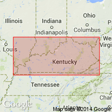
Pg. 145; also 1906, Kentucky Geol. Survey Bull., no. 7, p. 97. Duffin layer. Brownish-yellow limestone, 2 inches to 12 feet thick, having brecciated appearance, forming top of Devonian limestone in Lincoln, Montgomery, Boyle, Clark, and Garrard Counties, [east-central Kentucky]. Underlies Ohio shale; overlies other Devonian limestones. [See also Foerste (1906) entry under Boyle limestone.]
Named from Duffin cut, 0.75 mi north of Junction City, Boyle Co., KY.
Source: US geologic names lexicon (USGS Bull. 896, p. 638-639).

- Usage in publication:
-
- Duffin layer
- Modifications:
-
- Revised
- AAPG geologic province:
-
- Appalachian basin
Summary:
Duffin layer transferred to New Albany shale because at many places in KY lenses and layers of a limestone or dolomite similar in composition to Duffin layer and in some places carrying similar fossils, are interbedded in the black shale for 9 to 15 ft above its base. According to author, this indicates that basal sandy dolomitic Duffin layer belongs with New Albany period of deposition rather than with underlying Middle Devonian limestones.
Source: GNU records (USGS DDS-6; Reston GNULEX).
- Usage in publication:
-
- Duffin limestone facies
- Modifications:
-
- Revised
- Overview
- Dominant lithology:
-
- Dolomite
- AAPG geologic province:
-
- Appalachian basin
Summary:
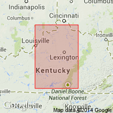
Portwood formation (new) contains three coeval facies: Duffin limestone or dolomite, Harg shale (new), and Ravenna shale (new). Duffin layer is mottled gray to brownish dolomite that commonly appears brecciated. Typically represented in Boyle, Lincoln, and Casey Cos., where it ranges from 3 to 8 ft thick, and eastward to Berea, thins to 1 ft at Crab Orchard. Harg replaces Duffin dolomite in area where former appears and is transitional between Duffin and Ravenna.
Source: GNU records (USGS DDS-6; Reston GNULEX).
- Usage in publication:
-
- Duffin†
- Modifications:
-
- Abandoned
- AAPG geologic province:
-
- Appalachian basin
Summary:
Campbell's (1946) definition of Portwood Member of Albany Shale is inadequate, hence term has been seldom used. Unit is potentially usable, however, and is easily defined. It here replaces Duffin, Harg, and Ravenna facies. Portwood is here defined as basal-most unit of the black-shale sequence characterized by substantial amount of limestone and dolomite. Top and bottom defined by sandy lag horizon. Unit is up to 4 m thick. Consists of four lithofacies. In large part coeval with Blocher Member.
Source: GNU records (USGS DDS-6; Reston GNULEX).
- Usage in publication:
-
- Duffin lithology
- Modifications:
-
- Revised
- Overview
- AAPG geologic province:
-
- Appalachian basin
Summary:
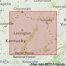
Authors follow de Witt (1981) in restricting the New Albany Shale to the Illinois basin and the Ohio Shale to the Appalachian basin. Ohio Shale terminology used wherever Three Lick Bed is recognizable in cores. Unlike de Witt (1981), authors do not use Chattanooga Shale in Knobs outcrop area of south-central KY. Most of New Albany correlates with the Huron Member of Ohio Shale. Upper 1 to 2 m correlates with Cleveland Member. Dolomitic interval at the base of the Huron herein referred to the "Duffin lithology," usage modified from Campbell (1946). Duffin lithology occurs in southern and east-central portions of outcrop belt.
Source: GNU records (USGS DDS-6; Reston GNULEX).
For more information, please contact Nancy Stamm, Geologic Names Committee Secretary.
Asterisk (*) indicates published by U.S. Geological Survey authors.
"No current usage" (†) implies that a name has been abandoned or has fallen into disuse. Former usage and, if known, replacement name given in parentheses ( ).
Slash (/) indicates name conflicts with nomenclatural guidelines (CSN, 1933; ACSN, 1961, 1970; NACSN, 1983, 2005, 2021). May be explained within brackets ([ ]).