

- Usage in publication:
-
- Du Noir member*
- Modifications:
-
- Named
- Dominant lithology:
-
- Limestone
- AAPG geologic province:
-
- Wind River basin
Summary:
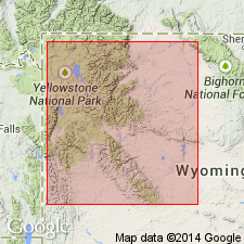
Named as the lower member of the Gallatin formation for exposures along Warm Springs Creek 2 mi west of Du Noir, Wind River Mountains, Fremont Co, WY in the Wind River basin. These exposures designated the type section. Is 47 ft thick at its type where it overlies Gros Ventre formation and underlies unnamed middle shaly part of Gallatin. Consists of (ascending): brown, gray, green, coarse-grained pebble limestone sprinkled with black and green glauconite; dark-gray limestone mottled with brown oolites; and a 2 ft thick gray and yellow fine-grained calcareous sandstone at top. Is a 35 ft thick gray and brown massive limestone with brown oolites in Crow Creek Canyon measured section, northern Owl Creek Range, and a 42 ft thick massive to thin-bedded pebbly limestone mottled brown and filled with brown oolites in Wind River Canyon measured section, northern Bridger Mountains. Cross sections. Trilobite fossils. Late Cambrian age.
Source: GNU records (USGS DDS-6; Denver GNULEX).

- Usage in publication:
-
- Du Noir member
- Modifications:
-
- Not used
- AAPG geologic province:
-
- Montana folded belt
Summary:
Pg. 1104. Du Noir member of Gallatin formation. Original nomenclature and definitions of formations in Wind River Canyon section is herein revised. Name Gallatin formation is replaced by Boysen formation (new). Because Upper-Middle Cambrian boundary is nearly 100 feet below base of Miller's Du Noir, member would have to be redefined to include many beds which Miller assigned to Middle Cambrian; hence, Du Noir member is not recognizable in Wind River Canyon, and lower member of Boysen is called Maurice member.
Source: US geologic names lexicon (USGS Bull. 1200, p. 1183).
- Usage in publication:
-
- Dunoir limestone
- Modifications:
-
- Revised
- AAPG geologic province:
-
- Yellowstone province
- Green River basin
- Bighorn basin
- Wind River basin
Summary:
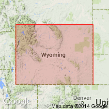
Gallatin formation raised to group rank and its members raised to formation rank in footnote on Chart II. Includes (ascending): Dunoir [sic] limestone (Dresbachian), Dry Creek shale (early Franconian), and Sage limestone (middle to late Franconian). Gallatin overlies Park shale (rank raised) of Gros Ventre group (rank raised). Gallatin unconformably underlies Darwin sandstone. This nomenclature is used from Jackson Hole in Yellowstone province, in southwest WY, Greater Green River basin, in the Bighorn and Wind River basins. Only the Sage limestone is present in eastern Bighorn basin.
Source: GNU records (USGS DDS-6; Denver GNULEX).
- Usage in publication:
-
- Du Noir limestone
- Modifications:
-
- Contact revised
- AAPG geologic province:
-
- Yellowstone province
- Wind River basin
- Green River basin
Summary:
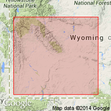
Is the lower formation of Gallatin group in the area of Teton Co, WY, Yellowstone province; Fremont Co, WY in the Wind River basin; Lincoln, Sublette, and Carbon Cos, WY in the Greater Green River basin. Upper contact revised in that Du Noir underlies Dry Creek shale member, basal member of Open Door limestone (named) of Gallatin group. Three Dresbachian faunal zones present in member. Faunal lists. Overlies Park shale. Cross sections.
Source: GNU records (USGS DDS-6; Denver GNULEX).
- Usage in publication:
-
- Dunoir limestone
- Modifications:
-
- Overview
- AAPG geologic province:
-
- Wind River basin
Summary:
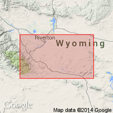
Dunoir was spelled Du Noir in author's 1955 report. Is the lower formation of Gallatin group in the Wind River basin. Overlies Park shale. Separated from overlying Dry Creek shale member, basal member of Open Door limestone, by an erosional surface. The Dry Creek weathers out as a re-entrant beneath the limestone cliff of the upper part of the Open Door. In subsurface, Dry Creek-Dunoir contact shows a drop in resistivity. Ranges from 75 to 100 ft thick. Consists in subsurface of a lower brown medium crystalline limestone, a middle brown calcareous fine-grained sandstone or sandy limestone, and an upper flat-pebble limestone conglomerate. Lower two-thirds has a lower Dresbachian CEDARIA zone fauna. Upper 12 to 25 ft yielded a middle Dresbachian CREPICEPHALUS fauna. These zones are representative Upper Cambrian zones. Lithology and fossil content suggest deposits show a gradual shallowing of the sea.
Source: GNU records (USGS DDS-6; Denver GNULEX).
- Usage in publication:
-
- Du Noir Limestone Member*
- Modifications:
-
- Revised
- Overview
- AAPG geologic province:
-
- Wind River basin
Summary:
Gallatin Limestone divided into Du Noir Limestone Member (base) and Open Door Limestone Member (top). Usage in this paper represents a change in stratigraphic rank used by Shaw (1955) for Gallatin (from group), and Du Noir and Open Door (from formation). Gallatin forms cliffs above shale slopes of Gros Ventre Formation and is separated from the overlying Bighorn Dolomite by an erosional unconformity. The formation is 265 to 365 ft thick in the Wind River Range, 235 to 455 ft thick in the Washakie Range, Owl Creek, and southern Bighorn Mountains, 209 ft thick along south edge of Wind River basin. The Du Noir described as a cliff-forming, thin-bedded, glauconitic and oolitic limestone with some flat-pebble conglomerate. The Open Door has a lower soft, green-gray shale with minor thin-bedded gray limestone, and an upper gray, thin-bedded to massive limestone and a few flat-pebble conglomerates. The members can be traced in the Washakie Range, along the south side of the Owl Creek Mountains, and into the southern Bighorn Mountains of WY in the Wind River basin. The boundary between the APHELASPIS and ELVINIA zones nearly corresponds to the Du Noir-Open Door contact. Is a marine deposit of Late Cambrian age. Cross sections.
Source: GNU records (USGS DDS-6; Denver GNULEX).
For more information, please contact Nancy Stamm, Geologic Names Committee Secretary.
Asterisk (*) indicates published by U.S. Geological Survey authors.
"No current usage" (†) implies that a name has been abandoned or has fallen into disuse. Former usage and, if known, replacement name given in parentheses ( ).
Slash (/) indicates name conflicts with nomenclatural guidelines (CSN, 1933; ACSN, 1961, 1970; NACSN, 1983, 2005, 2021). May be explained within brackets ([ ]).