The National Geologic Map Database is migrating to a new infrastructure. We apologize for any service disruptions during this process.
|
|---|


- Usage in publication:
-
- Douglas formation*
- Modifications:
-
- Original reference
- Dominant lithology:
-
- Shale
- Limestone
- AAPG geologic province:
-
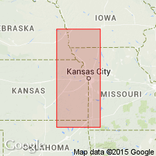
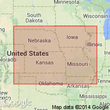
- Cherokee basin
- Forest City basin
Summary:
Pg. 93, 94. Douglas formation. The Lawrence shales are so distinct in character, and in connection with Oread limestone overlying them produce so prominent an escarpment, which extends entirely across the State from Leavenworth to southern line, that they, with overlying Oread limestone may well be grouped in one general formation. Overlies Garnett limestones. [Age is Pennsylvanian.]
[Named from Douglas Co., eastern KS.]
Source: US geologic names lexicon (USGS Bull. 896, p. 625-626).
- Usage in publication:
-
- Douglas formation
- Modifications:
-
- Revised
Summary:
Called the limestones underlying Lawrence shale the Stanton limestones, which he stated are = Garnett limestone. He also applied Weston shales to basal 40 to 75 feet of Lawrence shale and Iatan limestone to the thin limestone overlying the Weston. Age is Pennsylvanian.
Source: US geologic names lexicon (USGS Bull. 896, p. 625-626).

- Usage in publication:
-
- Douglas formation
- Modifications:
-
- Revised
- AAPG geologic province:
-
- Forest City basin
Summary:
Douglas formation. Divided into (ascending) Weston shale, Iatan limestone, Lawrence shale, and Oread limestone members. Thickness 125 to 128 feet. Age is Late Pennsylvanian (Missourian). Report includes cross sections, measured sections, geologic maps, stratigraphic tables.
Source: GNC KS-NE Pennsylvanian Corr. Chart, sheet 1, Oct. 1936; supplemental information from GNU records (USGS DDS-6; Denver GNULEX).

- Usage in publication:
-
- Douglas group*
- Modifications:
-
- Overview
Summary:
The Iatan and Weston were later (see E. Haworth and J. Bennett, 1908, Univ. Geol. Survey Kansas, v. 9) excluded from Lawrence shale and treated as disctinct formations within Douglas group. This definition of Douglas group (to include all beds between top of Stanton limestone below and top of Oread limestone at top) persisted until 1931, being the definition used by H. Hinds and F.C. Greene 1915, R.C. Moore 1917 and 1920, J.W. Beede 1922, and geologists generally.
Source: US geologic names lexicon (USGS Bull. 896, p. 625-626).
- Usage in publication:
-
- Douglas group
- Modifications:
-
- Revised
Summary:
Correlation chart. Redefined Douglas group by excluding Oread limestone at top and excluding at base the Weston shale, Iatan limestone, and basal part (later named Hardesty shale) of Lawrence shale. These 3 units which he excluded from base of Douglas group he transferred to Lansing group, but in 1932 he assembled them into a distinct group called Pedee group. Age is Late Pennsylvanian (Virgil).
Source: US geologic names lexicon (USGS Bull. 896, p. 625-626); GNC KS-NE Pennsylvanian Corr. Chart, sheet 1, Oct. 1936.

- Usage in publication:
-
- Douglas group
- Modifications:
-
- Revised
Summary:
Pg. 93, 96. It is proposed to redefine Douglas group to include essentially clastic strata occurring between the pre-Virgil unconformity and base of Oread limestone. Thus delimited the group will contain 3 formational units (in ascending order): Stranger formation (largely sandstone and sandy shale), Haskell limestone (thin, fairly persistent limestone that in many places has been mistaken for the Iatan), and Lawrence shale. [This use of Lawrence shale is a restriction.] In central Kansas, as in Woodson County, a prominet sandstone (Ireland) has been developed in Lawrence shale, not far below base of Oread formation. Overlies Pedee group and underlies Shawnee group redefined.
[This restricted definition of Douglas group was also adopted by R.C. Moore and G.E. Condra in their Oct. 1932 revised classification chart of the Pennsylvanian rocks of Kansas and Nebraska, and by N.D. Newell, 1935 (Kansas Geol. Survey Bull. 21).]
Source: US geologic names lexicon (USGS Bull. 896, p. 625-626); GNC KS-NE Pennsylvanian Corr. Chart, sheet 2, Oct. 1936.

- Usage in publication:
-
- Douglas group
- Modifications:
-
- Revised
Summary:
Pg. 146, etc. Douglas group divided into (descending): Lawrence shale restricted and Stranger formation expanded to include at top Robbins shale (new name for basal part of Lawrence shale of 1932 and 1935 classifications) and Haskell limestone. Douglas formation of Haworth extended from top of Oread limestone down to top of Stanton limestone. Age is Late Pennsylvanian (Virgil).
[These modified definitions have not yet (ca. 1938) been considered by the USGS for its publications. See "Modern classifications of the Pennsylvanian rocks of eastern Kansas and southeastern Nebraska," compiled by M.G. Wilmarth, Secretary of Committee on Geologic Names, USGS unpub. corr. chart, Oct. 1936, sheet 2.]
Source: US geologic names lexicon (USGS Bull. 896, p. 625-626); GNC KS-NE Pennsylvanian Corr. Chart, sheet 2, Oct. 1936.

- Usage in publication:
-
- Douglas group*
- Modifications:
-
- Areal extent
- AAPG geologic province:
-
- Anadarko basin
Summary:
Extended as an undivided unit into the subsurface of Baca County, Colorado, in the Anadarko basin. Overlies Peedee group (undivided) and underlies Shawnee group (undivided). Age is Late Pennsylvanian (Virgilian). Report includes correlation chart.
Source: Modified from GNU records (USGS DDS-6; Denver GNULEX).
- Usage in publication:
-
- Douglas group*
- Modifications:
-
- Overview
Summary:
Pg. 2034, 2035 (fig. 5). Douglas group. As now recognized, group comprises strata almost exclusively clastic occurring between disconformity at base of Virgilian series and base of Oread formation. Overlies Pedee group; underlies Shawnee group. Includes Stranger formation below and Lawrence formation above.
Source: US geologic names lexicon (USGS Bull. 1200, p. 1149).
For more information, please contact Nancy Stamm, Geologic Names Committee Secretary.
Asterisk (*) indicates published by U.S. Geological Survey authors.
"No current usage" (†) implies that a name has been abandoned or has fallen into disuse. Former usage and, if known, replacement name given in parentheses ( ).
Slash (/) indicates name conflicts with nomenclatural guidelines (CSN, 1933; ACSN, 1961, 1970; NACSN, 1983, 2005, 2021). May be explained within brackets ([ ]).