The National Geologic Map Database is migrating to a new infrastructure. We apologize for any service disruptions during this process.
|
|---|


- Usage in publication:
-
- Doe Creek [sandstone]
- Modifications:
-
- Original reference
- Dominant lithology:
-
- Sandstone
- AAPG geologic province:
-
- Anadarko basin
Summary:
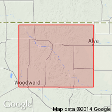
Pg. 196-197. Name applied to a sandstone, 6 to 36 feet thick, exposed in a line of disconnected hills that extend southwest from about 15 miles west of Alva, to near Woodward, a distance of about 40 miles. Sandstone is hard, highly cemented, fossiliferous. Considered younger than Verden sandstone although some workers have suggested that it is an extension of the Verden; both units are included in the Whitehorse [group]. Age is Permian.
Source: US geologic names lexicon (USGS Bull. 1200, p. 1129).
- Usage in publication:
-
- Doe Creek sandstone member*
- Modifications:
-
- Mapped 1:500k
- AAPG geologic province:
-
- Anadarko basin
Summary:
Mapped as [Doe Creek] sandstone member of Marlow formation. Age is Permian.
Source: US geologic names lexicon (USGS Bull. 1200, p. 1129).
- Usage in publication:
-
- Doe Creek sandstone member
- Modifications:
-
- Overview
- AAPG geologic province:
-
- Anadarko basin
Branson, C.C., 1955, Oklahoma stratigraphic names of recent date: Hopper, v. 15, no. 12, p. 135-138.
Summary:
Pg. 137. Doe Creek lies within the Marlow formation at a higher level than the Verden sandstone. The original Whitehorse sandstone of the Whitehorse Springs locality is the Doe Creek; name Whitehorse has been applied to the group consisting of the Marlow formation and Rush Springs sandstone. Derivation of name given.
Named from Doe Creek in T. 25 N., R. 18 W., Woodward Co., northwestern OK. Type section not designated; perhaps in Doe Creek mounds, which are buttes along valley of Doe Creek. Occurs in Cleveland Hills, Whitehorse mounds, Wildcat mounds, Woods Co., OK; Doe Creek mounds and vicinity of Woodward, Woodward Co., OK.
Source: US geologic names lexicon (USGS Bull. 1200, p. 1129).
For more information, please contact Nancy Stamm, Geologic Names Committee Secretary.
Asterisk (*) indicates published by U.S. Geological Survey authors.
"No current usage" (†) implies that a name has been abandoned or has fallen into disuse. Former usage and, if known, replacement name given in parentheses ( ).
Slash (/) indicates name conflicts with nomenclatural guidelines (CSN, 1933; ACSN, 1961, 1970; NACSN, 1983, 2005, 2021). May be explained within brackets ([ ]).