

- Usage in publication:
-
- Dexter sands
- Modifications:
-
- Original reference
- Dominant lithology:
-
- Sandstone
- Ironstone
- AAPG geologic province:
-
- South Oklahoma folded belt
Summary:
Pg. 285-298. Dexter sands. Extensive deposit of brown ferruginous sandstone heavily laden with siliceous ironstone. Middle division of Dakota or Lower Cretaceous Timbers formation. Underlies Timber Creek beds and overlies Basal clays of Dakota formation.
Named from exposures at Dexter, Cooke Co., northeastern TX.
Source: US geologic names lexicon (USGS Bull. 896, p. 606).
- Usage in publication:
-
- [Dexter sand member*]
- Modifications:
-
- Revised
- Dominant lithology:
-
- Sandstone
- Clay
- AAPG geologic province:
-
- Fort Worth syncline
- Ouachita folded belt
- South Oklahoma folded belt
- Strawn basin
Summary:
Used Dexter formation or Dexter sands to include Dexter sands of Taff and Basal clays of Taff. Underlies Lewisville beds ("Timber Creek beds") and overlies Grayson marl. [This is generally accepted definition of Dexter sand (ca. 1938). It is basal member of Woodbine sand.]
Source: US geologic names lexicon (USGS Bull. 896, p. 606).
- Usage in publication:
-
- Dexter member
- Modifications:
-
- Revised
- AAPG geologic province:
-
- Strawn basin
Summary:
Pg. 475, 476, 477. Dexter member of Euless formation. Dexter sand is basal member of newly defined Euless formation. [Age is Late Cretaceous (Gulf).]
Source: US geologic names lexicon (USGS Bull. 1200, p. 1109-1110).
- Usage in publication:
-
- Dexter member*
- Modifications:
-
- Revised
- Dominant lithology:
-
- Sandstone
- Clay
- Shale
- AAPG geologic province:
-
- Fort Worth syncline
- Ouachita folded belt
- South Oklahoma folded belt
Summary:
Termed Dexter member of Woodbine formation. In Cooke, Grayson, and Fannin Counties, northeastern Texas, stratigraphically restricted above to exclude 60 to 70 feet of sandstone and shale herein named Red Branch member. As restricted and redefined, Dexter member consists of 100 to 130 or 140 feet of nonmarine beds of white to ferruginous and siliceous sandstone with silty clay lenses, some carbonaceous clays at base, some scattered leaf and wood prints, and at top a persistent bed of varicolored clay ("rainbow clay"). Overlies Grayson marl. Age is Late Cretaceous.
Source: US geologic names lexicon (USGS Bull. 1200, p. 1109-1110); supplemental information from GNU records (USGS DDS-6; Denver GNULEX).

- Usage in publication:
-
- Dexter Member
- Modifications:
-
- Reference
- AAPG geologic province:
-
- Strawn basin
Summary:
Pg. 330-331 (credited to C.F. Dodge, Univ. Texas-Arlington, May 1970). Dexter Member of Woodbine Formation. Mostly sandstone with some ironstone, clay, and shale. Thickness 92.1 feet; base not exposed at reference locality. Age is Late Cretaceous. Recognized in north and northeastern Texas. Reference locality suggested by C.F. Dodge, 1968, GSA 2nd Ann. Mtg. South-Central Sec., p. 62-63. (For reference section, see Taff, 1893, Texas Geol. Survey 4th Ann. Rpt., pt. 1, p. 241-354.)
Reference locality: Farm Road 157 south of the bridge across roadcut along the west fork of the Trinity River; [south of West Fork of Trinity River, west of N. Collins Ave. (Farm Road 157) and south of Green Oaks Blvd., in vicinity of Lat. 32 deg. 47 min. N., Long. 97 deg. 05 min. 45 sec. W., Euless 7.5-min quadrangle (ca. 2000 ed.), eastern Tarrant Co., north-central TX].
[Additional locality information from USGS historical topographic map collection TopoView, ACME Mapper 2.0, and Montana State Univ. Graphical Locator, accessed February 16, 2012.]
Source: Publication.
- Usage in publication:
-
- Dexter Member
- Modifications:
-
- Areal extent
- AAPG geologic province:
-
- Ouachita folded belt
- South Oklahoma folded belt
Summary:
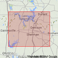
Dexter Member of Woodbine Formation. Recognized in Bryan, Choctaw, and Marshall Counties, southeastern Oklahoma. Consists of (ascending): (1) brown carbonaceous shale, 0 to 37 feet; (2) yellow-brown, ferruginous, cross-bedded sandstone, 85 to 90 feet; and (3) "rainbow clay," 40 feet. At places, unconformably overlies and channels into Grayson Formation (Comanchean); where Grayson is absent, unconformably overlies Bennington Limestone (Comanchean) or Pawpaw Sandstone Member of Bokchito Formation (Early Cretaceous). Underlies Red Branch Member of Woodbine. Age is Late Cretaceous (Gulfian).
Source: Publication.

- Usage in publication:
-
- Dexter Member
- Modifications:
-
- Mapped 1:250k
- Dominant lithology:
-
- Sandstone
- Clay
- AAPG geologic province:
-
- Fort Worth syncline
- South Oklahoma folded belt
Summary:
Pamphlet [p. 4]. Dexter Member of Woodbine Formation. In Texas, sandstone, white to red, brown, brownish-yellow, gray, ferruginous and siliceous cement, some silty clay lenses, carbonaceous clay at base, a persistent 20- to 30-foot interval of varicolored mottled clay at top, some leaf and wood impressions; thickness 100 to 140 feet. In Oklahoma, sandstone with subordinate shale; sandstone, yellowish-brown, fine- to medium-grained, ferruginous, cross-bedded; some ferruginous concretions, clay ironstones, and carbonized wood; uppermost part of member (Rainbow Clay [informal, unranked], unmapped) consists of 40 feet of variegated clay shale; thickness 120 to 130 feet. Is basal member of Woodbine Formation. Lies above Cretaceous Grayson Marl, Main Street Limestone, and Bennington Limestone, and below Red Branch Member of Woodbine Formation. Age is Late Cretaceous.
[Mapped on either side of Red River and southward to Lake Ray Roberts (btw. Sanger and Pilot Point); in Cooke, Denton, Fanin, and Grayson Cos., northeastern TX, and Bryan and Marshall Cos., southeastern OK; northeastern and central part of map sheet.]
Source: Publication.
For more information, please contact Nancy Stamm, Geologic Names Committee Secretary.
Asterisk (*) indicates published by U.S. Geological Survey authors.
"No current usage" (†) implies that a name has been abandoned or has fallen into disuse. Former usage and, if known, replacement name given in parentheses ( ).
Slash (/) indicates name conflicts with nomenclatural guidelines (CSN, 1933; ACSN, 1961, 1970; NACSN, 1983, 2005, 2021). May be explained within brackets ([ ]).