

- Usage in publication:
-
- Delaware Creek member
- Modifications:
-
- Named
- Dominant lithology:
-
- Shale
- Gypsum
- Limestone
- AAPG geologic province:
-
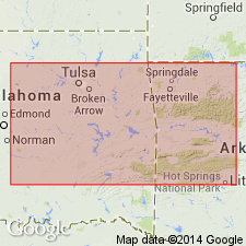
- South Oklahoma folded belt
Summary:
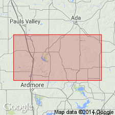
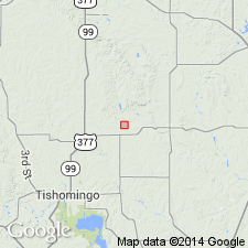
Named as middle member (of 3) of Caney shale; named from Delaware Creek which flows eastward in the Bromide-Wapanucka area. Type area designated in the northeast part of T2S, R7E, about 3 1/2 mi southwest of Bromide; type locality measured in NE1/4 sec 14, T2S, R7E, Johnston Co, OK, S. Oklahoma folded belt province. Occurs in northern Arbuckle Mountains of south-central OK. Consists of gray to dark-gray, non-calcareous to slightly calcareous, finely laminated to flaky, partly bituminous shale, locally rotten (shattered) with a considerable amount of finely crystalline gypsum along bedding planes. Gray to light-gray to light-buff limestone concretions common; concretions are generally fairly large and elliptical, more or less compressed across bedding plane, and commonly very large, up to 12 ft in diameter; they developed in fused clusters along bedding planes; some have crystalline barite. Calcareous concretions mostly distinctly septarian in structure. Thickness at type is about 270 ft; thickness southeast of Ahlosa is 150 +/-50 ft; thickness in area southwest of Bromide ranges from about 50 ft in west part of sec 13, T2S, R7E, to about 270 ft one mi farther northwest. Conformably overlies Ahlosa member (new); underlies Sand Branch member (new), both of Caney shale. Stratigraphic table; list of invertebrate fossils (conodonts, brachiopods, pelecypods). Of Mississippian (Meramec) age.
Source: GNU records (USGS DDS-6; Denver GNULEX).
- Usage in publication:
-
- Delaware Creek member
- Modifications:
-
- Overview
- AAPG geologic province:
-
- South Oklahoma folded belt
Summary:
Type section designated for Caney shale in sec 14, T2S, R7E, Johnston Co, OK in S. Oklahoma folded belt province; called section "A" in this report (where Caney is 180.85 ft thick). Augmented by sections "B" through "D". Caney contains three members, previously named by Elias (1956): Ahloso member (at base; previously called Ahlosa, but correct spelling is Ahloso), Delaware Creek member, and Sand Branch member (at top). Goddard shale is considered a facies of Sand Branch member. The Johns Valley shale, as here interpreted, contains in its lower part probably an Ahloso equivalent, definitely a Delaware Creek equivalent, and possibly a Sand Branch equivalent. Delaware Creek correlates with the Moorefield of northeastern OK and AR. Sand Branch contains a fauna similar to those of the Fayetteville and the Pitkin of northeastern OK. The Sycamore sandstone exposed below the Caney type section is quite unlike the Sycamore of its type area and may be a facies of Ahloso member. Type section for Ahloso is section "D," beds 10-18 (49.2 ft); type section for Delaware Creek is section "C," beds 38-97 (164.8 ft); and type section for Sand Branch is section "B," beds 4-37 (172.5 ft). Caney shale is of Mississippian age--its Ahloso member is of Meramecian age, its Delaware Creek member is of later Meramecian and early Chesterian age, and its Sand Branch member is of late Chesterian age.
Source: GNU records (USGS DDS-6; Denver GNULEX).
- Usage in publication:
-
- Delaware Creek Member*
- Modifications:
-
- Adopted
Summary:
Pg. A10-A11, A54, A56-A57 (fig. 5). Delaware Creek Member of Elias (1956) adopted as middle of three members of Caney Shale. Overlies Ahloso Member of Caney; underlies Sand Branch Member of Caney. Age is Late Mississippian (Chesterian; upper Visean of Europe); foram zones 16i and 16s, and ammonoid zones GONIATITES MULTILIRITUS and G. GRANOSUS. Present in northern and southern Arbuckle Mountains, south-central Oklahoma. [See also Mackenzie Gordon, Jr., and G.C. Stone, 1976, Arkansas Geol. Commission Symposium on the geology of the Ouachita Mountains, v. 1.]
Source: Publication.
For more information, please contact Nancy Stamm, Geologic Names Committee Secretary.
Asterisk (*) indicates published by U.S. Geological Survey authors.
"No current usage" (†) implies that a name has been abandoned or has fallen into disuse. Former usage and, if known, replacement name given in parentheses ( ).
Slash (/) indicates name conflicts with nomenclatural guidelines (CSN, 1933; ACSN, 1961, 1970; NACSN, 1983, 2005, 2021). May be explained within brackets ([ ]).