The National Geologic Map Database is migrating to a new infrastructure. We apologize for any service disruptions during this process.
|
|---|


- Usage in publication:
-
- Del Carmen Limestone
- Modifications:
-
- First used
- AAPG geologic province:
-
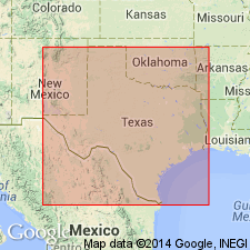
- Permian basin
Summary:
Pg. 12-33, pI. 1. Del Carmen Limestone. A thick-bedded dense hard cherty gray limestone that weathers brown. Thickness about 350 feet. Overlies Telephone Canyon Formation (new) and underlies Sue Peaks Formation (new). Age is Early Cretaceous.
Source: US geologic names lexicon (USGS Bull. 1350, p. 201).
- Usage in publication:
-
- Del Carmen Limestone
- Modifications:
-
- Named
- Dominant lithology:
-
- Limestone
- AAPG geologic province:
-
- Permian basin
Summary:
Pg. 36-40, pIs. Del Carmen Limestone. Formal proposal of name. Term is used to designate a lithostratigraphic unit that in general corresponds to Edwards Limestone in central Texas. Normally forms sheer escarpment in lower part of faulted fault blocks and is terminated above and below by slopes that are underlain by soft limestone and shale. Thickness 350 feet in the Sierra del Carmen to 475 feet at mouth of Santa Elena Canyon. Overlies Telephone Canyon Formation. Underlies Sue Peaks Formation. Age is Early Cretaceous.
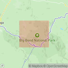
Name Del Carmen is from term Sierra del Carmen, a series of tilted faulted block mountains where the limestone is exposed. Forms lower part of most escarpments in the Sierra del Carmen, Big Bend National Park, southwestern TX. Also forms lower vertical walls at Santa Elena Canyon and is present at Mariscal Canyon and in Christmas Mountains.
Source: US geologic names lexicon (USGS Bull. 1350, p. 201).

- Usage in publication:
-
- Del Carmen Limestone
- Modifications:
-
- Mapped 1:250k
- AAPG geologic province:
-
- Permian basin
Summary:
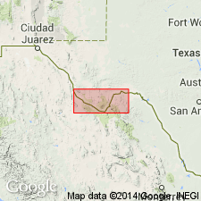
Is Lower Cretaceous formation mapped only at western margin of sheet along Rio Grande in southern Terrell Co, TX (Permian basin). Overlain by Sue Peaks Formation. Map unit described as limestone--microgranular to fine-grained, massive, medium-gray to medium dark-gray; only uppermost part crops out. Is not mapped east of Indian Creek, Terrell Co, TX. In map explanation, is schematically depicted to be equivalent to West Nueces Formation, lower part of Devils River Limestone, and lower part of Fort Terrett Member of Edwards Limestone.
Source: GNU records (USGS DDS-6; Denver GNULEX).
- Usage in publication:
-
- Del Carmen Limestone
- Modifications:
-
- Mapped 1:250k
- Dominant lithology:
-
- Limestone
- AAPG geologic province:
-
- Permian basin
Summary:
Del Carmen Limestone. Mapped in Terrell, Brewster, and Presidio Counties, Texas. Mapped (undifferentiated) with Telephone Canyon Formation in eastern Brewster County, and with Santa Elena Limestone, Sue Peaks Formation, and Telephone Canyon Formation in Terlingua and Christmas-Rosillos Mountain areas, and Tascotal Mesa, Agua Fria, and Santiago Peak quadrangles. Consists of limestone, microgranular to fine-grained, massive, chert nodules and masses up to 10 inches in size and beds exceeding 10 feet in length, gray; weathers shades of dark-brown, yellowish-brown, and pinkish-brown; rudistids and milliolids common; forms sheer escarpments. Thickness 445 feet in eastern part of Black Gap area, 350 feet in northern Sierra del Carmen, 475 feet at mouth of Santa Elena Canyon, and 300 to 350 feet in Shafter area. Overlies Telephone Canyon Formation. Underlies Sue Peaks Formation. Age is Early Cretaceous.
Source: Publication; supplemental information from GNU records (USGS DDS-6; Denver GNULEX).
For more information, please contact Nancy Stamm, Geologic Names Committee Secretary.
Asterisk (*) indicates published by U.S. Geological Survey authors.
"No current usage" (†) implies that a name has been abandoned or has fallen into disuse. Former usage and, if known, replacement name given in parentheses ( ).
Slash (/) indicates name conflicts with nomenclatural guidelines (CSN, 1933; ACSN, 1961, 1970; NACSN, 1983, 2005, 2021). May be explained within brackets ([ ]).