


- Usage in publication:
-
- Davis coal member
- Modifications:
-
- Principal reference
- Dominant lithology:
-
- Coal
- AAPG geologic province:
-
- Illinois basin
Summary:
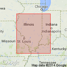
Pg. 32, 33, 46 (table 1), 64, pl. 1. Davis coal member of Spoon formation (new) of Kewanee group (new). Present in southeastern and southwestern Illinois and western Kentucky. Assigned member status to Spoon formation. Occurs above Stonefort limestone member and below DeKoven coal member. Thickness about 3.5 feet. Coal named by Lee (1916, Kentucky Geol. Survey, 4th ser., v. 4, pt. 2); reference of Owen (1856, Kentucky Geol. Survey Bull., v. 1, ser. 1) incorrect. Age is Pennsylvanian. Presentation of new rock-stratigraphic classification of Pennsylvanian strata in Illinois.
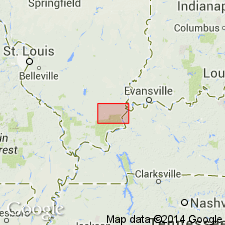
Type locality: Davis mine, 0.5 mi east of DeKoven, Shawneetown quadrangle, Union Co., KY.
Source: US geologic names lexicon (USGS Bull. 1200, p. 1049).

- Usage in publication:
-
- Davis Coal Member
- Modifications:
-
- Revised
- AAPG geologic province:
-
- Illinois basin
Summary:
The Spoon-Carbondale boundary is here revised downward approximately 70 ft, from the base of the Colchester Coal Member to the base of the Davis Coal Member. Unit is therefore reassigned from the Spoon Formation to the Carbondale Formation. Davis is described as a bright-banded, blocky coal, with no significant shale partings. Coal is overlain by 2 to 3 ft of hard, black, fissile shale with basal shell hash. Shale is overlain by 20 to 25 ft of medium to dark gray, silty shale, medium gray siltstone, and light gray, shaly sandstone, capped by Dekoven underclay. Age is Middle Pennsylvanian.
Source: GNU records (USGS DDS-6; Reston GNULEX).
- Usage in publication:
-
- Davis Coal Member
- Modifications:
-
- Overview
- AAPG geologic province:
-
- Illinois basin
Summary:
The Davis, at the base of the Carbondale, is the thickest and most widespread coal below the Colchester Coal Member in the study area. Thickness averages about 4 ft and ranges from 2 to 6 ft. Coal increases in depth northward where it reaches 1,200 ft. Typically underlies 10 to 35 ft of black, highly fissile, carbonaceous marine shale, which separates the Davis from the Dekoven.
Source: GNU records (USGS DDS-6; Reston GNULEX).
- Usage in publication:
-
- Davis Coal Member
- Davis coal bed
- Modifications:
-
- Revised
- AAPG geologic province:
-
- Illinois basin
Summary:
Pg. 1 (footnote), 2 (fig. 1), 3 (footnote), 7, 9-10, 11, pl. 1. Davis Coal Member of Carbondale Formation (Illinois); Davis coal bed of Carbondale Formation (Kentucky). Chosen, along with Seelyville Coal Member, as basal boundary of Carbondale, based on lithologic characteristics, widespread usage, and mappability. Overlies Tradewater Formation of Raccoon Creek Group. Equivalent to: basal part of Seelyville Coal Member of Carbondale in southwestern and east-central Illinois, and western Kentucky; basal part of Seelyville Coal Member of Linton Formation of Carbondale Group in western and southwestern Indiana; and Wiley Coal Member of Carbondale in western Illinois. Age is Middle Pennsylvanian (Desmoinesian). Classification proposed in this report agreed upon by State Geological Surveys of Illinois, Indiana, and Kentucky. Report includes correlation chart, history of nomenclature.
Source: Publication.
For more information, please contact Nancy Stamm, Geologic Names Committee Secretary.
Asterisk (*) indicates published by U.S. Geological Survey authors.
"No current usage" (†) implies that a name has been abandoned or has fallen into disuse. Former usage and, if known, replacement name given in parentheses ( ).
Slash (/) indicates name conflicts with nomenclatural guidelines (CSN, 1933; ACSN, 1961, 1970; NACSN, 1983, 2005, 2021). May be explained within brackets ([ ]).