

- Usage in publication:
-
- Davis formation
- Modifications:
-
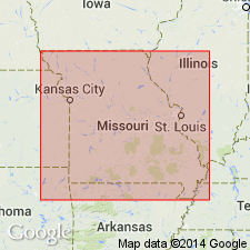
- Areal extent
- Dominant lithology:
-
- Shale
- Limestone
- Dolomite
- AAPG geologic province:
-
- Ozark uplift
Summary:
Pg. 231. Davis formation. Bluish, impure, calcareous shale intercalated with thin beds of magnesium limestone and dolomite. Thickness 100 feet. Underlies Derby and overlies Bonne Terre [Bonneterre] formations. [Age is Late Cambrian.]
Source: US geologic names lexicon (USGS Bull. 896, p. 575).

- Usage in publication:
-
- Davis Member
- Modifications:
-
- Overview
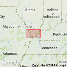
- AAPG geologic province:
-
- Illinois basin
Summary:
Davis Member is recognized as base of Franconia Formation throughout IL except the extreme north where entire Franconia is represented by shaly and glauconitic sandstone, and in the southeast (Lawrence and Hamilton Cos.) where the unit appears to grade into dolomite and is included in Knox Megagroup. Grades from shaly sandstone in the north to silty, argillaceous dolomite in the south. Characterized by green, gray, or red shale partings and by flat-pebble conglomerate. Ranges from a few feet thick in the north to about 100 ft in the south.
Source: GNU records (USGS DDS-6; Reston GNULEX).
- Usage in publication:
-
- Davis Formation*
- Davis Member*
- Modifications:
-
- Overview
- AAPG geologic province:
-
- Illinois basin
- Ozark uplift
Summary:
Used as Cambrian (Croixan) Davis Member of Franconia Formation of Knox Group in IL and Davis Formation (no group assignment) in MO.
Source: GNU records (USGS DDS-6; Reston GNULEX).
For more information, please contact Nancy Stamm, Geologic Names Committee Secretary.
Asterisk (*) indicates published by U.S. Geological Survey authors.
"No current usage" (†) implies that a name has been abandoned or has fallen into disuse. Former usage and, if known, replacement name given in parentheses ( ).
Slash (/) indicates name conflicts with nomenclatural guidelines (CSN, 1933; ACSN, 1961, 1970; NACSN, 1983, 2005, 2021). May be explained within brackets ([ ]).