

- Usage in publication:
-
- Cyprian sandstone member*
- Modifications:
-
- Named
- Dominant lithology:
-
- Sandstone
- AAPG geologic province:
-
- Williston basin
Summary:
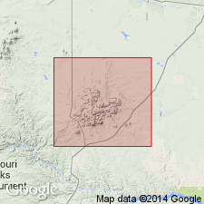
Named for exposures in Cyprian Creek on southwest side of road that crosses NE1/4 NW1/4 sec 31, T25N, R24E, 2 miles south of Landusky, Phillips Co, MT in the Williston basin. Occurs near the middle of the Thermopolis shale. Mapped (geologic map) in southwest corner of map area around Bull and Cyprian Creeks. No type locality designated. Forms conspicuous ridges and cliffs. Columnar section. Is about 25 ft thick. Consists of coarse-grained, massively bedded sandstone that has pebbles of variously colored (black, brown, gray, green) chalcedony. Becomes shaly to the east. May be equivalent to the Newcastle sandstone of WY and SD, and to the Viking sandstone of AL and SA. Was called Muddy sand in some earlier reports. Of Cretaceous age.
Source: GNU records (USGS DDS-6; Denver GNULEX).
For more information, please contact Nancy Stamm, Geologic Names Committee Secretary.
Asterisk (*) indicates published by U.S. Geological Survey authors.
"No current usage" (†) implies that a name has been abandoned or has fallen into disuse. Former usage and, if known, replacement name given in parentheses ( ).
Slash (/) indicates name conflicts with nomenclatural guidelines (CSN, 1933; ACSN, 1961, 1970; NACSN, 1983, 2005, 2021). May be explained within brackets ([ ]).