The National Geologic Map Database is migrating to a new infrastructure. We apologize for any service disruptions during this process.
|
|---|


- Usage in publication:
-
- Curtis formation*
- Modifications:
-
- Named
- Dominant lithology:
-
- Conglomerate
- Sandstone
- Shale
- AAPG geologic province:
-
- Paradox basin
Summary:
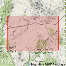
Named as the third formation (of four formations) of San Rafael Group (new) for Curtis Point, near head of Cottonwood Springs Wash, northeast side of San Rafael Swell, Emery Co, UT in the Paradox basin. Type section measured on Curtis Point, Saleratus (Lost Springs) Wash, sec 34, T19S, R13E, UT in the Paradox basin. Is a fossiliferous sequence of greenish-gray glauconitic conglomerates, sandstones, and shales. Is mostly sandstone in beds 6 in to 3 ft thick, cross-bedded and ripple marked. Is 193 ft thick at type locality (also called section) [Curtis Point] and 252 ft thick at north end of Swell. Is 40 ft thick at Sand Creek in north part of Waterpocket fold. Not recognized at Circle Cliffs and in Henry Mountains. Overlies Entrada sandstone (new); underlies Summerville formation (new). Thought to be a shallow water marine deposit. Assigned to the [Late] Jurassic. Has the same fossils as those from the Sundance formation of WY.
Source: GNU records (USGS DDS-6; Denver GNULEX).
- Usage in publication:
-
- Curtis formation*
- Modifications:
-
- Revised
- Areal extent
- AAPG geologic province:
-
- Plateau sedimentary province
- Paradox basin
Summary:
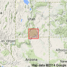
Extended south to the Kaiparowits region, Plateau sedimentary province from its original area in the San Rafael Swell, Paradox basin mapped in Kane and Garfield Cos. Is one of four formations--Carmel formation (first use), Entrada sandstone, Curtis and Summerville formations (listed in ascending order)--of the San Rafael group. Assigned to the Upper Jurassic.
Source: GNU records (USGS DDS-6; Denver GNULEX).
- Usage in publication:
-
- Curtis Member*
- Modifications:
-
- Revised
- Areal extent
- AAPG geologic province:
-
- Green River basin
- Wasatch uplift
- Uinta uplift
- Snake River basin
Summary:
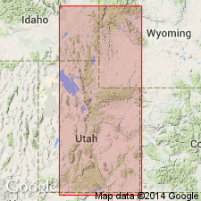
Lower part of Stump Formation (revised, redescribed) is identical to Curtis Formation of San Rafael Swell. Stratigraphic rank of Curtis changed and it is assigned to Stump as its basal member. The member extended to northern UT where it occurs from Rich, Summit and Wasatch Cos east to Uintah Co, Wasatch and Uinta uplifts, and Uinta basin, and to southwest WY and northwest CO in the Greater Green River basin. South and east of the Uinta Mountains in CO, the Curtis equivalent is in the Sundance. Extends farther south in UT than the overlying Redwater Member, also newly assigned to the Stump. Ranges from 76-113 m thick. Consists of gray, brown-gray and some red, very fine to fine grained, ripple-marked, ledgy or cliff forming, glauconitic, fossiliferous (tracks, trails, marine bivalves) sandstone in lower part and green-gray to olive-green, soft, flaky fissile claystone, some very thin platy sandstone, some fossiliferous, oolitic limestone slabs (with oysters and crinoid stems), and many large, flat, lenticular, yellow-gray limestone concretions in upper part. Measured sections; cross sections. Assignment to middle Callovian based on position above Preuss Sandstone (early Callovian) and below Redwater (early to middle Oxfordian).
Source: GNU records (USGS DDS-6; Denver GNULEX).
- Usage in publication:
-
- Curtis Member*
- Modifications:
-
- Mapped 1:24k (Moffat Co, CO)
- Dominant lithology:
-
- Sandstone
- AAPG geologic province:
-
- Green River basin
Summary:
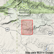
Is Middle Jurassic member of the Stump Formation (Middle and Upper Jurassic) mapped in southwest Moffat Co, CO (Greater Green River basin). Unconformably overlies Entrada Sandstone (Middle Jurassic); unconformably underlies Redwater Member (Upper Jurassic) of Stump Formation. Map unit described as distinctive resistant light-gray or light-greenish-gray thin- to medium-bedded, cross-bedded fossiliferous glauconitic medium- to coarse-grained sandstone. Commonly contains clay galls and carbonaceous trash. Sandstone speckled with chert grains of various colors. Previously the type Curtis was thought to equal all of the Curtis Formation of the Uintas, but regional stratigraphic studies (Pipiringos and Imlay, 1979) indicate that it equals only the lower part and is considered to be the Curtis Member of the Stump Formation. Thickness 0 m to at least 10 m (30 ft). About 8 m (26 ft) thick in the road cut about 1 km (0.8 mi) east of Plug Hat Rock. About 1 m (3 ft) thick near well in NW1/4 sec. 7, T3N, R103W. Thickens to about 5 m (15 ft) on the eastern side of the road in the NE1/4 sec. 8, but in NE1/4 NW1/4 sec. 9, T3N, R103W, only a coquina limestone--less than 1 m (3 ft) thick--of the Redwater Member is present; about 1 km (0.8 mi) east of this location, sandstone of the Curtis Member is at least 4 m (13 ft) thick. In NW1/4 NE1/4 sec. 10, T3N, R103W, Curtis Member is about 0.5 m (1.5 ft) thick. At least 2 m (6 ft) thick near Fletcher Cabin in northeastern part of the quadrangle. Generally thickens west of the quadrangle (Kinney, 1955) and southward in the subsurface (G. N. Pipiringos, unpub. data).
Source: GNU records (USGS DDS-6; Denver GNULEX).
- Usage in publication:
-
- Curtis Formation*
- Modifications:
-
- Overview
- AAPG geologic province:
-
- Paradox basin
Summary:
As a formation of San Rafael Group, lies above the J-3 unconformity in Henry basin and San Rafael Swell, UT, or Paradox basin. Underlies Summerville Formation of San Rafael Group. Is not present in Black Mesa or Kaiparowits basins. Deposited in normal marine waters. Fossiliferous. Of Middle Jurassic age. Correlation chart.
Source: GNU records (USGS DDS-6; Denver GNULEX).
For more information, please contact Nancy Stamm, Geologic Names Committee Secretary.
Asterisk (*) indicates published by U.S. Geological Survey authors.
"No current usage" (†) implies that a name has been abandoned or has fallen into disuse. Former usage and, if known, replacement name given in parentheses ( ).
Slash (/) indicates name conflicts with nomenclatural guidelines (CSN, 1933; ACSN, 1961, 1970; NACSN, 1983, 2005, 2021). May be explained within brackets ([ ]).