

- Usage in publication:
-
- Crystal Lake Tuff*
- Modifications:
-
- Named
- Dominant lithology:
-
- Tuff
- AAPG geologic province:
-
- San Juan Mountains province
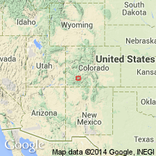
Summary:
Named for exposures on Crystal Lake, its type area, about 5 km northwest of Lake City, Hinsdale Co, CO in the San Juan Mountain province. Is about 50 m thick at its type where it consists of a black basal vitrophyre, densely welded red-brown tuff in its interior, and an upper zone of vapor-phase crystallization. Contains about 5 percent phenocrysts of sanidine and plagioclase. Is thickest (about 200 m) in northern moat of Uncompahgre caldera. Erupted about 27.0-27.5 m.y. ago in the Oligocene probably from within the Silverton caldera. Is younger than Fish Canyon Tuff and older than Carpenter Ridge Tuff. Has reverse magnetic polarity.
Source: GNU records (USGS DDS-6; Denver GNULEX).
- Usage in publication:
-
- Crystal Lake Tuff*
- Modifications:
-
- Areal extent
- Overview
- AAPG geologic province:
-
- San Juan Mountains province
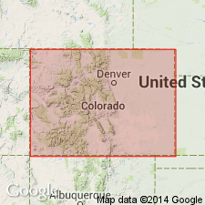
Summary:
Areal extent of Crystal Lake Tuff in southwestern Colorado shown on distribution map; present in Hinsdale, San Juan, and Ouray Counties (San Juan Mountain province). Composed mostly of rhyolite. Related to Silverton caldera. Had an estimated volume of 25 to 100 cubic km. Age ranges from greater than 26.7 to less than 27.8 m.y.
Source: Modified from GNU records (USGS DDS-6; Denver GNULEX).
For more information, please contact Nancy Stamm, Geologic Names Committee Secretary.
Asterisk (*) indicates published by U.S. Geological Survey authors.
"No current usage" (†) implies that a name has been abandoned or has fallen into disuse. Former usage and, if known, replacement name given in parentheses ( ).
Slash (/) indicates name conflicts with nomenclatural guidelines (CSN, 1933; ACSN, 1961, 1970; NACSN, 1983, 2005, 2021). May be explained within brackets ([ ]).