The National Geologic Map Database is migrating to a new infrastructure. We apologize for any service disruptions during this process.
|
|---|


- Usage in publication:
-
- Cox formation
- Modifications:
-
- Original reference
- Dominant lithology:
-
- Sandstone
- Limestone
- Shale
- AAPG geologic province:
-
- Permian basin
Summary:
Pg. 47, geol. map. Cox formation of Fredericksburg group. Massive soft brownish sandstone, some intercalated gray limestone, and near base a red-drab shaly member 100 feet thick. Thickness averages 600 feet. Is middle formation of Fredericksburg group. Overlies Campagrande formation and underlies Finlay formation. Age is Early Cretaceous (Comanche).
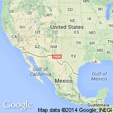
Named from Cox Mountain where formation is prominently exposed, 12 mi north of Eagle Flat, El Paso Co. [now in Hudspeth Co.], western TX.
Source: Publication; US geologic names lexicon (USGS Bull. 896, p. 535).
- Usage in publication:
-
- Cox sandstone*
- Modifications:
-
- Revised
- AAPG geologic province:
-
- Permian basin
Summary:
Cox sandstone of Trinity group. Transferred this formation to Trinity group. Age is Early Cretaceous (Comanche).
[GNC remark (ca. 1936, US geologic names lexicon, USGS Bull. 896, p. 535): This formation is now regarded as a transgressing unit, which in places extends upward into Fredericksburg time.]
Source: US geologic names lexicon (USGS Bull. 896, p. 535).
- Usage in publication:
-
- Cox Sandstone
- Modifications:
-
- Mapped 1:250k
- Dominant lithology:
-
- Sandstone
- Shale
- Limestone
- Marl
- AAPG geologic province:
-
- Permian basin
Summary:
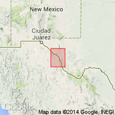
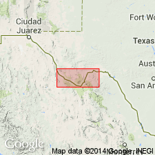
Cox Sandstone. Mapped at north end of Chinati Mountains, Presidio County, Texas. Consists of sandstone, shale, limestone, and marl. Upper part, about one-third limestone, hard, nodular, medium- to thick-bedded, rest mostly shale, gray, red, and purple with interbeds of marl and sandstone, abundant EXOGYRA TEXANA; lower part, sandstone, fine- to medium-grained, hard, resistant, thick-bedded, cross-bedded, quartz cemented, weathers reddish-brown, interbedded with sandstone, fairly soft, cross-bedded, light colored and with shale, gray, red, and purple; a few thin beds of fossiliferous limestone toward base, hard, medium-gray. Thickness about 450 feet. Overlies Bluff Mesa Formation with gradational contact. Age is Early Cretaceous.
Source: Publication; supplemental information from GNU records (USGS DDS-6; Denver GNULEX).
For more information, please contact Nancy Stamm, Geologic Names Committee Secretary.
Asterisk (*) indicates published by U.S. Geological Survey authors.
"No current usage" (†) implies that a name has been abandoned or has fallen into disuse. Former usage and, if known, replacement name given in parentheses ( ).
Slash (/) indicates name conflicts with nomenclatural guidelines (CSN, 1933; ACSN, 1961, 1970; NACSN, 1983, 2005, 2021). May be explained within brackets ([ ]).