The National Geologic Map Database is migrating to a new infrastructure. We apologize for any service disruptions during this process.
|
|---|


- Usage in publication:
-
- Coventry conglomerate
- Modifications:
-
- Original reference
- Dominant lithology:
-
- Conglomerate
- AAPG geologic province:
-
- New England province
Summary:
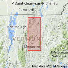
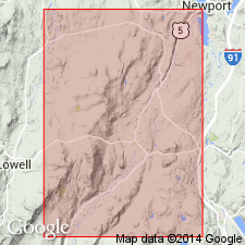
Pg. 47. Coventry conglomerate. Appears 10 miles north of Irasburg, Orleans County, northeastern Vermont. Contains quartz pebbles 1 inch to 1 foot diameter and fragments of Cambrian schist which are occasionally at right angles. Also carries angular fragments of Ordovician slate and limestone. It is a meta-conglomerate, for the lime has been calcitized. Can not be contemporaneous with Irasburg conglomerate. May have been formed at close of Ordovician or may represent a fault breccia.
Source: US geologic names lexicon (USGS Bull. 896, p. 533).
- Usage in publication:
-
- Coventry phase
- Modifications:
-
- Revised
- AAPG geologic province:
-
- New England province
Summary:
Pg. 107-110. Coventry phase of Irasburg conglomerate. Is markedly different from any of the other phases of that formation. It is characterized by well-rounded, smoothed, sometimes faceted and sometimes apparently striated boulders of pure white quartz from an inch to a foot in diameter. Fragments of Cambrian schists up to 1 foot in diameter and set at right angles to each other are embedded in an Ordovician paste of limestone and slate. Writer believes this rock is a fault breccia conglomerate. This breccia-conglomerate is located about 10 miles north of Craftsbury, near contact of Cambrian and Ordovician terranes. Main road from Newport to South Troy passes over this terrane [and crosses northern part of Coventry Township, Orleans County, northeastern Vermont]. Age is Early Ordovician.
Source: US geologic names lexicon (USGS Bull. 896, p. 533).
For more information, please contact Nancy Stamm, Geologic Names Committee Secretary.
Asterisk (*) indicates published by U.S. Geological Survey authors.
"No current usage" (†) implies that a name has been abandoned or has fallen into disuse. Former usage and, if known, replacement name given in parentheses ( ).
Slash (/) indicates name conflicts with nomenclatural guidelines (CSN, 1933; ACSN, 1961, 1970; NACSN, 1983, 2005, 2021). May be explained within brackets ([ ]).