The National Geologic Map Database is migrating to a new infrastructure. We apologize for any service disruptions during this process.
|
|---|


- Usage in publication:
-
- Cougar Point formation
- Modifications:
-
- Revised
- Redescribed
- Dominant lithology:
-
- Tuff
- Lava
- Ash
- AAPG geologic province:
-
- Great Basin province
Summary:
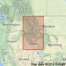
Pg. 6 (table 1), 9, 11. Cougar Point Formation in Idavada Volcanics. As defined by Malde and Powers (1962) the Idavada is sufficiently varied so that it seems desirable to recognize it as a group. Cougar Point formation is middle unit of Idavada in Trapper Creek area, Idaho. Overlies Beaverdam formation (new) and underlies Jenny Creek formation. Thickness about 700 feet in lower part of Trapper Creek. Rocks comprising Cougar Point in Trapper Creek area have been traced continuously westward across Cassia arch where they thicken to 1,500 to 1,700 feet on scarp west of Salmon Falls Reservoir a few miles southwest of Rogerson, Idaho. From this area they have been traced 25 miles farther west into Jarbidge region, Nevada, where Cougar Point has its type area. Formation crops out locally in Snake River Plains, where other names (Mount Bennett rhyolite, Shoshone Falls andesite, and Walcott tuff) have been applied to it by earlier workers. Since Cougar Point represents a thick, representative section, the name is used here even though it may not have priority. Also seems desirable to recognize the Cougar Point because it occurs in sections that have yielded floras in adjacent Nevada, and which are described in present report. Age is middle Miocene (Barstovian).
Source: US geologic names lexicon (USGS Bull. 1350, p. 179).
- Usage in publication:
-
- Cougar Point welded tuff*
- Modifications:
-
- Named
- Dominant lithology:
-
- Tuff
- AAPG geologic province:
-
- Great Basin province
- Snake River basin
Summary:
Pg. M13-M15, pI. 1 (geol. map). Cougar Point welded tuff. Forms massive to columnar cliffs. Reddish- or yellowish-brown and brownish-gray where holocrystalline; black or gray to orange-red where glassy. Much of the welded tuff is vesicular. Phenocrysts, including quartz, sanidine, plagioclase, pigeonite, and accessory zircon, magnetite, and apatite make up as much as 10 percent. Maximum thickness about 1,250 feet (at type). Overlies Jenny Creek tuff (new); underlies Banbury formation. Malde and Powers (1962) applied name Idavada volcanics to unit that includes Cougar Point welded tuff and Jenny Creek tuff and possibly also other rocks not represented in Jarbidge quadrangle. Age is considered Pliocene, based on correlation with unnamed beds that overlie Humboldt formation and carry an early Pliocene mammalian fauna. Adopted by the USGS.
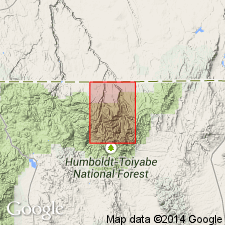
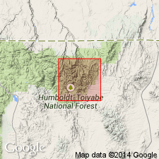
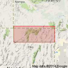
Type locality: below Cougar Point on East Fork of Jarbidge River, Jarbidge quadrangle, Elko Co., NV. Named from Cougar Point. Occupies most of northern third of Jarbidge quadrangle, but is also exposed on margins of Snake River plain at many places from Goose Creek area in Cassia Co., ID, to western Owyhee Co., ID, and on north side of Snake River in southern slopes of Mount Bennett near Mountain Home, ID.
Source: US geologic names lexicon (USGS Bull. 1350, p. 179); GNU records (USGS DDS-6; Denver GNULEX).
- Usage in publication:
-
- Cougar Point Welded Tuff*
- Modifications:
-
- Age modified
- AAPG geologic province:
-
- Great Basin province
Summary:
Age changed from Pliocene based on 12.2 +/-0.8 m.y. K-Ar on sanidine. Mapped with other volcanic rocks on geologic map. Area is in Elko Co, NV in the Great Basin province.
Source: GNU records (USGS DDS-6; Denver GNULEX).
- Usage in publication:
-
- Cougar Point Welded Tuff*
- Modifications:
-
- Revised
- AAPG geologic province:
-
- Great Basin province
- Snake River basin
Summary:
Revised in that the Cougar Point Welded Tuff underlies the newly named Big Island Formation in Elko Co, NV in the Great Basin province and southern ID in the Snake River basin. Of late Miocene age.
Source: GNU records (USGS DDS-6; Denver GNULEX).
For more information, please contact Nancy Stamm, Geologic Names Committee Secretary.
Asterisk (*) indicates published by U.S. Geological Survey authors.
"No current usage" (†) implies that a name has been abandoned or has fallen into disuse. Former usage and, if known, replacement name given in parentheses ( ).
Slash (/) indicates name conflicts with nomenclatural guidelines (CSN, 1933; ACSN, 1961, 1970; NACSN, 1983, 2005, 2021). May be explained within brackets ([ ]).