

- Usage in publication:
-
- Cotter dolomite*
- Modifications:
-
- Named
- Dominant lithology:
-
- Dolomite
- AAPG geologic province:
-
- Ozark uplift
Summary:
Consists of two kinds of dolomite: a white to buff or gray, fine-grained, argillaceous, earthy textured, relatively soft variety known as "cotton rock"; and a gray, medium-grained, more massive variety that weathers hackly on the surface and becomes dark upon exposure. Contains some chert and a little interbedded saccharoidal sandstone and green shale. Thickness is 500 feet or greater. Unconformably underlies Powell limestone. Base not exposed in these quadrangles, but in Missouri and farther east in Arkansas where erosion has cut through it, Jefferson City limestone underlies it. [Age is Early Ordovician (Beekmantown).]
Name credited to E.O. Ulrich who named it for Cotter, Baxter Co., northern AR.
Source: GNU records (USGS DDS-6; Reston GNULEX).
- Usage in publication:
-
- [Cotter Dolomite and Jefferson City Dolomite, undifferentiated]
- Modifications:
-
- Overview
- AAPG geologic province:
-
- Central Kansas uplift
- Nemaha anticline
- Chautauqua platform
Summary:
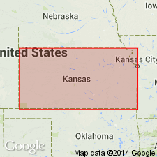
(Paleozoic Era; [Cambrian through Mississippian Systems] by E.D. Goebel, p. 13.) Jefferson City Dolomite and Cotter Dolomite. Because the Cotter Dolomite and Jefferson City Dolomite recognized in outcrops are not distinctly separable in the subsurface on lithologic criteria, they are treated as a unit. They consist mainly of coarsely granular, cherty dolomite. The upper part of the sequence includes much oolitic chert which becomes white and decreases in volume toward the base where white, tripolitic chert becomes abundant. These rocks unconformably underlie different formations, such as the St. Peter Sandstone on the flank of the Southeast Nebraska arch, the Chattanooga Shale on the Chautauqua arch, and Pennsylvanian rocks on parts of the Central Kansas uplift and Nemaha anticline. The Jefferson City Dolomite probably is conformable on the Roubidoux Formation. The Cotter-Jefferson City sequence ranges in thickness from 0 feet in northern Kansas to more than 650 feet in Cowley County in southern Kansas. Age is Late Cambrian to Early Ordovician.
Source: Publication.

- Usage in publication:
-
- Cotter Dolomite
- Modifications:
-
- Overview
- AAPG geologic province:
-
- Ozark uplift
Summary:
Shakopee Dolomite in Illinois is equivalent to Jefferson City and Cotter Dolomites of Missouri and to the south may include strata equivalent to younger Powell and Smithville-Black Rock Formations.
Source: GNU records (USGS DDS-6; Reston GNULEX).
- Usage in publication:
-
- Cotter Dolomite
- Modifications:
-
- Overview
- AAPG geologic province:
-
- Ozark uplift
Summary:
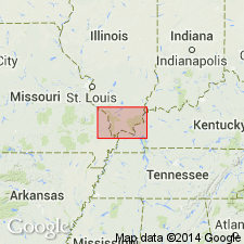
Cotter Dolomite has not been mapped in subsurface east of outcrop belt near western edge of Paducah quadrangle. A fairly persistent sandstone bed about 60 feet above base of Cotter is informally called Swan Creek sandstone. Age is Early Ordovician (Canadian).
Source: GNU records (USGS DDS-6; Reston GNULEX).

- Usage in publication:
-
- Cotter Dolomite*
- Modifications:
-
- Overview
- AAPG geologic province:
-
- Illinois basin
Summary:
Cotter Dolomite of Early Ordovician (Canadian) age occurs only in Missouri part of quadrangle, but is present throughout the entire St. Louis area. Includes some Powell Dolomite. Also mapped undivided with Jefferson City Dolomite.
Source: GNU records (USGS DDS-6; Reston GNULEX).

- Usage in publication:
-
- Cotter Dolomite*
- Modifications:
-
- Areal extent
- AAPG geologic province:
-
- Ozark uplift
Summary:
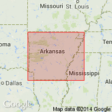
Cotter Dolomite crops out near western edge of Paducah quadrangle. Jefferson City, Cotter, Powell, and Smithville Dolomites not mapped consistently between adjacent 7.5-minute quadrangles within Paducah quad. All consist of more or less silty, sandy, and cherty dolomite. Indistinguishable in subsurface except possibly through study of insoluble residues. Sequence is equivalent to Shakopee Dolomite in IL and KY. Age is Early Ordovician (Canadian).
Source: GNU records (USGS DDS-6; Reston GNULEX).

- Usage in publication:
-
- Cotter Dolomite*
- Modifications:
-
- Areal extent
- AAPG geologic province:
-
- Upper Mississippi embayment
- Illinois basin
Summary:
Cotter Dolomite mapped undivided with Jefferson City Dolomite in subsurface of Upper Mississippi embayment, Missouri, and Illinois basin, Illinois. Age is Early Ordovician (Canadian).
Source: GNU records (USGS DDS-6; Reston GNULEX).
- Usage in publication:
-
- [Cotter Dolomite and Jefferson City Dolomite, undifferentiated]
- [Cotter Formation and Jefferson City Formation, undifferentiated]
- Modifications:
-
- Overview
- AAPG geologic province:
-
- Ozark uplift
Summary:
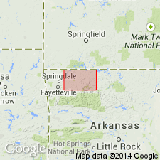
Pg. 3-4. The Cotter is composed of dolostone of predominantly two types: a fine-grained, argillaceous, earthy textured, relatively soft, white to buff or gray dolostone called "cotton rock," and a more massive, medium-grained, gray dolostone that weathers somewhat hackly and becomes dark on exposure. The formation contains chert, some minor beds of greenish shale, and occasional thin interbedded sandstone. The chert nodules associated with the Cotter frequently have concentric light and dark bands. The fossils known from the Cotter are rare but include gastropods, cephalopods, and reef-building algae. To date, there has been no success in differentiating the Cotter Formation from the Jefferson City Formation in Arkansas although the contact is considered disconformable. The thickness is thought to be 340 feet in vicinity of Cotter but the interval may reach as much as 500 feet thick in places. Present in northern Arkansas, Ozark Plateaus; southern Missouri, and Oklahoma. Age is Early Ordovician.
Type locality: starting at valley bottom just upstream from west end of the old White River bridge at Cotter and extending to top of hill westward along the old U.S. Highway 62, Baxter Co., AR (Purdue and Miser, 1916).
Source: Publication.
For more information, please contact Nancy Stamm, Geologic Names Committee Secretary.
Asterisk (*) indicates published by U.S. Geological Survey authors.
"No current usage" (†) implies that a name has been abandoned or has fallen into disuse. Former usage and, if known, replacement name given in parentheses ( ).
Slash (/) indicates name conflicts with nomenclatural guidelines (CSN, 1933; ACSN, 1961, 1970; NACSN, 1983, 2005, 2021). May be explained within brackets ([ ]).