

- Usage in publication:
-
- Coronado quartzite*
- Modifications:
-
- Named
- Dominant lithology:
-
- Sandstone
- Conglomerate
- AAPG geologic province:
-
- Basin-and-Range province
Summary:
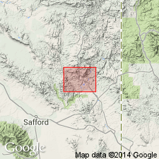
Named (apparently) for Coronado Mountain in Clifton-Morenci district, Greenlee Co, AZ in the Basin-and-Range province. No type locality designated. Geologic map. Consists of brown, pink, or maroon quartzitic sandstone. Usually jointed. Measured section 243 ft thick southwest of Morenci has a coarse, basal sandstone that is succeeded by quartzitic conglomerate, and quartzitic sandstone. Conglomerate consists of well-washed cobbles and pebbles of quartzite from the pre-Cambrian. Deposited in a large body of water. Basal conglomerate probably fluviatile; upper part marine. Maximum thickness of 250 ft. Rests on Precambrian granite. Conformably overlain by Longfellow limestone (new). Is of Cambrian? age. Age based on stratigraphic position.
Source: GNU records (USGS DDS-6; Denver GNULEX).
- Usage in publication:
-
- Coronado quartzite
- Modifications:
-
- Age modified
- AAPG geologic province:
-
- Basin-and-Range province
Summary:
Age may be Middle Cambrian but could be younger. Is in the Basin-and-Range province.
Source: GNU records (USGS DDS-6; Denver GNULEX).
- Usage in publication:
-
- Coronado Sandstone*
- Modifications:
-
- Age modified
- Redescribed
- Dominant lithology:
-
- Sandstone
- AAPG geologic province:
-
- Basin-and-Range province
- Pedregosa basin
Summary:
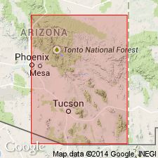
Redescribed--changed from Coronado Quartzite to Coronado Sandstone everywhere. Extended to Dos Cabezas and Chiricahua Mountains, AZ in the Pedregosa basin, Aravaipa area, AZ in the Basin-and-Range province, and to central Peloncillo Mountains, NM in the Pedregosa basin to replace Bolsa Quartzite of various authors. Line of nomenclature change from Coronado (west) to Bliss (east), its general correlative, is east of Peloncillo Mountains and eastern Hidalgo Co. Is of Middle (locally) and Late Cambrian age.
[= Bolsa Quartzite of Jones and Bacheller, 1953, New Mexico Geol. Soc. Field Conf. Gdbk., no. 4, and Gillerman, 1958, New Mexico Bur. Min. Res. Bull., no. 57.]
Source: GNU records (USGS DDS-6; Denver GNULEX).
- Usage in publication:
-
- Coronado Sandstone*
- Modifications:
-
- Areal extent
- AAPG geologic province:
-
- Pedregosa basin
- Basin-and-Range province
Summary:
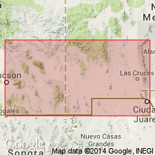
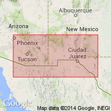
Areal limits of Coronado shown extending from Hidalgo, Grant, and southern Catron Cos, NM west into eastern Cochise, southern Greenlee, and Graham Cos, AZ. These areas are part of the Pedregosa basin and Basin-and-Range province. Coronado underlies El Paso Limestone and overlies Precambrian granodiorite in a section 536 ft thick measured at Nantac Rim, lat 33 deg 13 min N and long 109 deg 40 3/4 min W. Is the oldest Paleozoic sandstone of the central region that correlates with parts of Bolsa Quartzite and Abrigo Formation to west, and to part of Bliss Sandstone to east.
Source: GNU records (USGS DDS-6; Denver GNULEX).
For more information, please contact Nancy Stamm, Geologic Names Committee Secretary.
Asterisk (*) indicates published by U.S. Geological Survey authors.
"No current usage" (†) implies that a name has been abandoned or has fallen into disuse. Former usage and, if known, replacement name given in parentheses ( ).
Slash (/) indicates name conflicts with nomenclatural guidelines (CSN, 1933; ACSN, 1961, 1970; NACSN, 1983, 2005, 2021). May be explained within brackets ([ ]).