

- Usage in publication:
-
- Confederate limestone member
- Modifications:
-
- Original reference
- Dominant lithology:
-
- Limestone
- AAPG geologic province:
-
- South Oklahoma folded belt
Summary:
Pg. 15. Confederate limestone member, basal member of Hoxbar formation. Present in Carter County, south-central Oklahoma. Reaches maximum thickness of 60+/- feet at its westernmost outcrop, northwest of Ardmore. Elsewhere it contains conglomerate streaks, with chert and limestone pebbles. Age is Pennsylvanian.
Source: US geologic names lexicon (USGS Bull. 896, p. 505).
- Usage in publication:
-
- Confederate limestone member
- Modifications:
-
- [Principal reference]
- Dominant lithology:
-
- Limestone
- AAPG geologic province:
-
- South Oklahoma folded belt
Summary:
Pg. 39-40. Confederate limestone member, basal member of Hoxbar formation. Consists of two resistent ledges, each 15 to 20 feet thick, of coarsely granular, semi-crystalline gray to buff limestone, sparingly fossiliferous, separated by a 30-foot interval of weaker material, part of which is also limestone. Thins in general to southeast and thickens to northwest. Liess 400+/- feet below Union Dairy member of Hoxbar, and about 3,300 feet above Arnold member of Deese formation. Age is Pennsylvanian. Report includes fossil list, geologic map, columnar section.
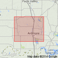
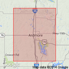
Named because it is well exposed a short distance west of Oklahoma Confederate Veterans Home, in SE/4 sec. 36, T. 4 S., R. 1 E., on southwest outskirts of Ardmore, Carter Co., south-central OK.
Source: US geologic names lexicon (USGS Bull. 896, p. 505); supplemental information from GNU records (USGS DDS-6; Denver GNULEX).
- Usage in publication:
-
- Confederate limestone member
- Modifications:
-
- Revised
- AAPG geologic province:
-
- South Oklahoma folded belt
Summary:
Pg. 1085. Confederate limestone member of Hoxbar formation. According to revised mapping Confederate limestone member has been traced southeast INTO, instead of BELOW, Westheimer member as mapped west of Hoxbar, near south line of Carter County, south-central Oklahoma. Westheimer limestone can now be dropped and Confederate, geographically preferable, be substituted. This places base of Hoxbar formation slightly higher than base as originally mapped by Goldston (1922). However, as this member is in that area the lowest of the conspicuous limestones which here constitute the most essential distinguishing characteristic of Hoxbar formation as compared to the formations above and below it, and also includes the lowest limestone conglomerate (possibly intraformational) above Bostwick member of Dornick Hills formation it appears most appropriate to continue to regard base of Hoxbar as coincident with base of Confederate limestone member. Age is Pennsylvanian.
Source: US geologic names lexicon (USGS Bull. 896, p. 505).

- Usage in publication:
-
- Confederate limestone
- Modifications:
-
- Revised
- AAPG geologic province:
-
- South Oklahoma folded belt
Summary:
Pg. 697, Chart no. 6 (column 37, Ardmore basin, southern Oklahoma, collated by R.C. Moore). Confederate limestone. Reallocated to Deese group and given formational status in Ardmore basin, southern Oklahoma. Base of overlying Hoxbar group is drawn above the Confederate limestone, rather than just below it, as the boundary between Desmoinesian and Missourian deposits preferably should coincide with the Deese-Hoxbar contact. Age of Confederate limestone is [late, but not latest Middle Pennsylvanian]; late, but not latest Desmoinesian.
[Shown on Pennsylvanian chart correlative with Exline limestone of Appanoose group in Iowa (col. 31), Lenapah limestone of Marmaton group in Kansas, Nebraska, northern Oklahoma and northwestern Arkansas (cols. 33 and 34), Holdenville formation in central Oklahoma and Arkansas valley (col. 36), and Capps limestone member of East Mountain shale of Lone Camp group in south-central Texas (col. 38).]
Source: Publication; US geologic names lexicon (USGS Bull. 1200, p. 914).
- Usage in publication:
-
- Confederate limestone
- Modifications:
-
- Revised
- AAPG geologic province:
-
- South Oklahoma folded belt
Summary:
Pg. 6 (fig. 2). Confederate limestone at base of Hoxbar group, Missouri series. At type locality, the Confederate comprises 30 feet of finely crystalline limestone varying from thin bedded to massive and from cream to dark tan in color; overlying 10 feet of calcareous shale with 2 feet or more of dense limestone at base. Crinerville beds (or member) occur 400 to 500 feet above base of Hoxbar.
Source: US geologic names lexicon (USGS Bull. 1200, p. 914).
- Usage in publication:
-
- Confederate limestone
- Modifications:
-
- Revised
- Areal extent
- AAPG geologic province:
-
- Anadarko basin
Summary:
Pg. 221. Confederate limestone. In Cement Pool area, Caddo and Grady Counties, the Confederate overlies West Arm formation (new) of Deese Group.
Source: US geologic names lexicon (USGS Bull. 1200, p. 914).
For more information, please contact Nancy Stamm, Geologic Names Committee Secretary.
Asterisk (*) indicates published by U.S. Geological Survey authors.
"No current usage" (†) implies that a name has been abandoned or has fallen into disuse. Former usage and, if known, replacement name given in parentheses ( ).
Slash (/) indicates name conflicts with nomenclatural guidelines (CSN, 1933; ACSN, 1961, 1970; NACSN, 1983, 2005, 2021). May be explained within brackets ([ ]).