

- Usage in publication:
-
- Cokedale Formation*
- Modifications:
-
- Named
- Dominant lithology:
-
- Siltstone
- Sandstone
- AAPG geologic province:
-
- Montana folded belt
Summary:
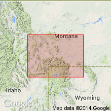
Named as basal formation of Livingston Group (rank raised) for former town of Cokedale, Park Co, MT, Montana folded belt province. Type section is in S1/2 sec 23 and NW1/4 sec 26, T2S, R8E where the formation is 1,550 ft thick and conformably overlies Eagle Sandstone. Basal contact not distinct. Top of Eagle arbitrarily placed at top of arkosic sandstone above uppermost minable coal, the Cokedale No. 5. Top placed at base of Sulphur Flats Sandstone Member (new) of Miner Creek Formation (new) of Livingston Group, or at base of Lennep Sandstone. Consists of olive-gray siltstone (50%) that is usually massive, tuffaceous. Some siltstone beds are carbonaceous, containing leaf impressions, pollen, spores, fresh-water mollusks indicative of transitional brackish-water marine to continental deposition. Ridge-forming yellow green, massive to thin-bedded, cross-bedded, fine- to coarse-grained, locally conglomeratic sandstone forms 35% of formation. Sandstone contains angular to subround grains of volcanic rock, plagioclase, augite, hornblende, magnetite, biotite, and quartz cemented mainly by silica. Sandstone contains volcanic rock pebbles from Elkhorn Mountains Volcanics, petrified wood, and dinosaur bones. Claystone, tuff, bentonite, and coal in lower part. One prominent sandstone bed near top probably Parkman Sandstone equivalent. Assigned to Late Cretaceous, Campanian. Correlation chart.
Source: GNU records (USGS DDS-6; Denver GNULEX).
- Usage in publication:
-
- Cokedale Formation*
- Modifications:
-
- Overview
- AAPG geologic province:
-
- Montana folded belt
- Central Montana uplift
Summary:
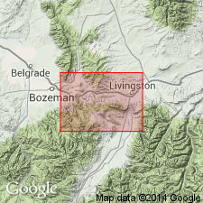
Pg. C6-C7, C42-C46, C77-C84, pls. 1, 2. Cokedale Formation of Livingston Group. Mapped between Livingston, Park County, Montana, and Bozeman, Gallatin County, Montana, notably along Miner Creek (type area). Consists of siltstone, and lesser sandstone, mudstone, water-laid tuff, bentonite, and carbonaceous claystone; coal is present in lower part. Sedimentary rocks derived mostly from volcanic rocks of andesitic composition. Siltstone is massive, tuffaceous, olive-gray, weathers yellowish-gray. Sandstone is dusky yellow green, thin-bedded to massive, cross-bedded, fine- to coarse-grained, locally conglomeratic. Uppermost 16-feet-thick sandstone is probably western tongue of Parkman Sandstone. Described in detail from measured type section; thickness 1,550 feet. Gradationally overlies Eagle Sandstone (contact placed arbitrarily) and underlies Miner Creek Formation, both of Livingston Group. Is western nonmarine equivalent of Claggett Shale and part of Judith River Formation of central Montana, or part of Two Medicine Formation of northwestern Montana. Tuffs in middle of formation may correlate with middle member of Elkhorn Mountains Volcanics (K-Ar age 76 +/-2 Ma). Is lower part of leaf beds member of Weed's (1893, p. 22) Livingston Formation. Fossiliferous; leaf impressions, pollen and spores, dinosaur bone fragments, fresh-water mollusks (identified by R.H. Tschudy, G.E. Lewis, and D.W. Taylor, USGS). Age is Late Cretaceous (Campanian). Report includes geologic map, correlation chart.
Source: Publication.
- Usage in publication:
-
- Cokedale Formation*
- Modifications:
-
- Overview
- AAPG geologic province:
-
- Montana folded belt
Summary:
Correlates with Sedan Formation, a new unit in Livingston Group in the Sedan area, Gallatin, Park, and Meagher Cos, MT, and with Maudlow Formation, a new unit in Livingston Group in the Maudlow area, Gallatin Co, MT. The study area lies within the Montana folded belt province. Assigned to the Campanian, Late Cretaceous.
Source: GNU records (USGS DDS-6; Denver GNULEX).
- Usage in publication:
-
- Cokedale Formation*
- Modifications:
-
- Biostratigraphic dating
- Age modified
- AAPG geologic province:
-
- Montana folded belt
Summary:
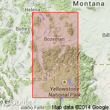
Lower part of Cokedale Formation, basal formation of Livingston Group in the Livingston area, MT, Montana folded belt province, yielded palynomorphs (20 species) no older than middle Santonian. Three species among these indicate PROTEACIDITES RETUSUS Interval Zone. The middle part of the Cokedale yielded palynomorphs (41 species) indicative of the middle to late Campanian age AQUILLAPOLLENITES QUADRILOBUS Interval Zone. Lower age limit also constrained by age of fossils indicative of P. RETUSUS Interval Zone in the upper part of the Cody Shale in strata about 1,000 ft below the Cokedale. Upper age limit constrained by presence of early Maastrichtian palynomorphs (46 species) from the overlying Miner Creek Formation of the Livingston Group; this fossil assemblage suggests upper AQUILLAPOLLENITES Interval Zone. Correlation chart. Is correlated with upper part of Everts Formation and overlying Livingston Formation in Madison Range. Is correlated with upper part of Everts and Landslide Creek Formation of Gardner area.
Source: GNU records (USGS DDS-6; Denver GNULEX).
For more information, please contact Nancy Stamm, Geologic Names Committee Secretary.
Asterisk (*) indicates published by U.S. Geological Survey authors.
"No current usage" (†) implies that a name has been abandoned or has fallen into disuse. Former usage and, if known, replacement name given in parentheses ( ).
Slash (/) indicates name conflicts with nomenclatural guidelines (CSN, 1933; ACSN, 1961, 1970; NACSN, 1983, 2005, 2021). May be explained within brackets ([ ]).