

- Usage in publication:
-
- Cibolo limestones
- Modifications:
-
- Original reference
- Dominant lithology:
-
- Limestone
- AAPG geologic province:
-
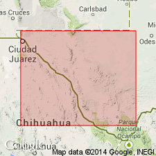
- Permian basin
Summary:
Pg. 10-25. Cibolo limestones. Consist of (descending): hard yellow dolomitic limestone, 650 feet; dark, even-bedded, compact limestone, including some sandy strata, 470 feet; thin-bedded limestone containing sponge spicules, 85 feet; grayish white, heavy-bedded, brecciated limestone, 133 feet; gray marly shale, containing some lenticular ledges of organic and siliceous sand, forming basal transition beds, 100 feet. Fossiliferous. Top formation of Chinati series. Unconformably underlie Lower Cretaceous Presidio beds and overlie Alta beds. [Age is Permian.]
Named from Cibolo Creek and Cibolo Ranch, Shafter district, Chinati Mountains, Presidio Co., southwestern TX.
Source: US geologic names lexicon (USGS Bull. 896, p. 443-444).
- Usage in publication:
-
- [Cibolo formation]
- Modifications:
-
- Age modified
- AAPG geologic province:
-
- Permian basin
Summary:
Pg. 908. [Cibolo formation]. State the underlying Cieneguita and Alta beds of Udden have proved to be Permian. [See also C.L. Baker, 1929 (Univ. Texas Bull., no. 2901, p. 73+).]
Source: US geologic names lexicon (USGS Bull. 896, p. 443-444).

- Usage in publication:
-
- Cibolo formation*
- Modifications:
-
- Overview
- AAPG geologic province:
-
- Permian basin
Summary:
Pg. 165. Cibolo formation [name adopted by the USGS]. Consists largely of limestones. At base is a marly shale, 100 feet thick, containing lenses of siliceous and organic sand. This marly shale is followed by massive limestones, 133 feet; thin-bedded limestone and sandstone containing sponge spicules, 85 feet; thin-bedded limestone with platy cherts, 450 feet; and yellow massive dolomite limestone, 650 feet. The formation is overlain by Cretaceous and igneous rocks.
According to R.E. King (Univ. Texas Bull. 3042, pt. 2, p. 17, 1930 [1931]) the fossils of this formation indicate its correlation with the Word (Delaware Mountain). Among those obtained are ammonoids WAAGENOCERAS, MEDLICOTTIA, AGATHICERAS GIRTYI, ADRIANITES MARATHONENSIS, and STACHEOCERAS GILLIAMENSE. [See also C.L. Baker, 1929 (Univ. Texas Bull., no. 2901, p. 73+).]
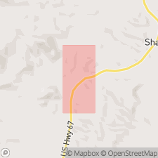
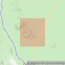
Type locality stated to be on east bluff of Sierra Alta Creek near Cibolo Ranch, 3 mi north of Shafter; thickness, 1,450 feet. [See also J.W. Skinner, 1940, Upper Paleozoic section of Chinati Mountains, Presidio Co., TX, AAPG Bull., v. 24, no. 1, p. 184 (fig. 2).]
Source: Publication.
- Usage in publication:
-
- Cibolo formation
- Modifications:
-
- Areal extent
- AAPG geologic province:
-
- Permian basin
Skinner, J.W., 1940, Upper Paleozoic section of Chinati Mountains, Presidio County, Texas: American Association of Petroleum Geologists Bulletin, v. 24, no. 1, p. 180-188.
Summary:
Pg. 180-188. Cibolo formation. Contact with underlying Alta formation transitional. All except uppermost part of Cibolo of Udden is regarded as late Wolfcamp (early Permian) in age. At type section, upper member of Cibolo is overthrust on limestones of late Permian (Capitan) age.
Source: US geologic names lexicon (USGS Bull. 1200, p. 800-801).
- Usage in publication:
-
- Cibolo formation
- Modifications:
-
- Revised
- Age modified
- Mapped
- AAPG geologic province:
-
- Permian basin
Summary:
Fig. 3 (facing p. 24), p. 32 (table 1), 44-54, 168 (measured section 5), geol. map. Cibolo formation. Restricted to Leonard series, based on fossils [listed]. Upper boundary = top of reef exposed in Udden's typical section. Lower boundary placed at base of limestone conglomerate in middle portion of Udden's "brecciated zone." At type consists of (descending): reddish yellow dense reefy limestone, 189 feet; light-brown sandy shale, 74 feet; dark-gray cherty limestone, 162 feet; light-brown sandy shale, 24 feet; purplish gray, non-fossiliferous sandstone and chert, 31 feet; limestone cobble conglomerate, 14 feet. Maximum thickness 494+/- feet. Underlies Ross Mine formation (new) of Guadalupe age, and overlies Alta formation of Wolfcamp age. Correlative with Bone Spring Limestone. Age is Early Permian (Leonard).
Type section stated to be at confluence of Cibolo and Sierra Alta Creeks, about 1 mi south of Cibolo Ranch headquarters, 3+ mi S. 75.5 deg. W. of Shafter triangulation station.
Source: Publication; US geologic names lexicon (USGS Bull. 1200, p. 800-801).
- Usage in publication:
-
- Cibolo Formation
- AAPG geologic province:
-
- Permian basin
For more information, please contact Nancy Stamm, Geologic Names Committee Secretary.
Asterisk (*) indicates published by U.S. Geological Survey authors.
"No current usage" (†) implies that a name has been abandoned or has fallen into disuse. Former usage and, if known, replacement name given in parentheses ( ).
Slash (/) indicates name conflicts with nomenclatural guidelines (CSN, 1933; ACSN, 1961, 1970; NACSN, 1983, 2005, 2021). May be explained within brackets ([ ]).