

- Usage in publication:
-
- Chignik formation*
- Modifications:
-
- Original reference
- Biostratigraphic dating
- Dominant lithology:
-
- Sandstone
- Shale
- Conglomerate
- Coal
- AAPG geologic province:
-
- Alaska Peninsula province
Summary:
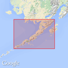
Pg. 24, 41-48, map. Chignik formation. Conglomerate, sandstone, shale, and coal seams, 600+ feet thick. Underlies Kenai formation (Eocene) and overlies Herendeen limestone (Lower Cretaceous). Occurs on shores of Chignik and Herendeen Bays and near Douglas Village. Age is Late Cretaceous, based on fossils [listed].
Type section: in Whalers Creek, 0.5 mi from shore of Chignik Lagoon, Alaska Peninsula, southwestern AK.
Source: US geologic names lexicon (USGS Bull. 896, p. 429).
- Usage in publication:
-
- Chignik formation*
- Modifications:
-
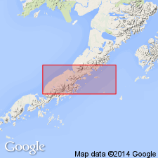
- Areal extent
- AAPG geologic province:
-
- Alaska Peninsula province
- Alaska Southwestern region
Summary:
Rocks of Late Cretaceous age in vicinity of Kaguyak and in sea cliffs from mouth of Big River to Swikshak River (formerly included as part of Chignik formation by Atwood, 1911) are here named Kaguyak formation because this section has relatively little in common with coal-bearing sequence at Chignik, about 250 mi to southwest.
Source: GNU records (USGS DDS-6; Menlo GNULEX).
- Usage in publication:
-
- Chignik Formation*
- Modifications:
-
- Biostratigraphic dating
- Overview
- AAPG geologic province:
-
- Alaska Peninsula province
- Alaska Southwestern region
Summary:
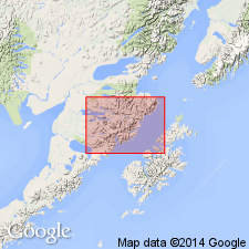
Columnar section described along northwest side of Chignik Lagoon from Parallel Creek to Native Village. Chignik was subdivided into three unnamed members by Martin (1926); middle one is coal bearing. Lower member yielded only marine invertebrate fossils; middle member yielded fossil plants and few marine mollusks (INOCERAMUS) and upper member variety of fauna and flora. Chignik can be assigned to INOCERAMUS SCHMIDTI Zone of Campanian age.
Source: GNU records (USGS DDS-6; Menlo GNULEX).
- Usage in publication:
-
- Chignik Formation
- Modifications:
-
- Revised
- AAPG geologic province:
-
- Alaska Peninsula province
- Alaska Southwestern region
Summary:
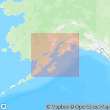
Basal interval of Chignik Formation defined as Coal Valley Member (new). Chignik Formation and Coal Valley Member shown on geologic map of Alaska Peninsula. Chignik conformably underlies Hoodoo Formation (new).
Source: Modified from GNU records (USGS DDS-6; Menlo GNULEX).
- Usage in publication:
-
- Chignik Formation*
- Modifications:
-
- Reference
- AAPG geologic province:
-
- Alaska Peninsula province
- Alaska Southwestern region
Summary:
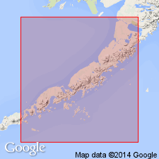
Mapped in Chignik and Sutwik Island [1 x 4.5 degree] quadrangles, Alaska. Reference section designated on north shore between cove (Boomers Cove) 1.5 km north of airstrip and sand spit at entrance to lagoon. Described as cyclic near-shore marine and nonmarine sedimentary rock about 500 m thick. Unconformably overlies Herendeen Limestone and Staniukovich Formation; conformably underlies Hoodoo Formation. Fossils locally abundant, mainly pelecypods and ammonites, indicate Campanian and early Maestrichtian (Late Cretaceous) age (citing D.L. Jones, written commun., 1979).
Source: GNU records (USGS DDS-6; Menlo GNULEX).
For more information, please contact Nancy Stamm, Geologic Names Committee Secretary.
Asterisk (*) indicates published by U.S. Geological Survey authors.
"No current usage" (†) implies that a name has been abandoned or has fallen into disuse. Former usage and, if known, replacement name given in parentheses ( ).
Slash (/) indicates name conflicts with nomenclatural guidelines (CSN, 1933; ACSN, 1961, 1970; NACSN, 1983, 2005, 2021). May be explained within brackets ([ ]).