

- Usage in publication:
-
- Chickasaw Creek siliceous shale
- Modifications:
-
- Original reference
- Dominant lithology:
-
- Shale
- AAPG geologic province:
-
- Ouachita folded belt
Summary:
Pg. 854 (fig. 1), 856, 874-878. Name Chickasaw Creek siliceous shale proposed for uppermost formation in Stanley group. Gray to black shale containing white globular bodies, many of which were originally radiolarians, making it easily recognizable wherever found. Middle and upper parts contain thin lenses of white, gray, and brown chert conglomerate. Measurable thickness at type locality about 270 feet; thins along southern rim of Tuskahoma syncline to only a few feet. Overlies Moyers formation (new); contact not exposed at type locality but is well exposed at site designated as second type locality. Underlies Wildhorse Mountain formation (new) of Jackfork group [contact placed below CALAMITES bed]. Fossiliferous (radiolarians, conodonts, brachiopods). Age is Carboniferous; included in Pushmataha series (new) of Bendian period. Report includes correlation chart, measured sections.
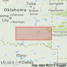
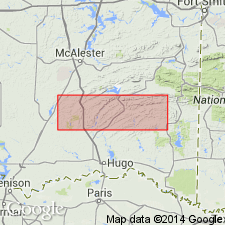
Type locality: immediately south of Chickasaw Creek in center of south line of the SW/4, 600 feet north of section line of sec. 7, T. 1 S., R. 13 E., Atoka Co., southeastern OK. Second type locality: center of W/2 NE/4 NE/4 sec. 26, T. 1 S., R. 12 E. Named from Chickasaw Creek. Is one of most widespread and best displayed siliceous shales in the Ouachita Mountains.
Source: US geologic names lexicon (USGS Bull. 1200, p. 761); supplemental information from GNU records (USGS DDS-6; Denver GNULEX).
- Usage in publication:
-
- Chickasaw Creek formation
- Modifications:
-
- Age modified
- AAPG geologic province:
-
- Ouachita folded belt
Summary:
Pg. 38-40. Chickasaw Creek formation of Stanley group. Formation consists of from 80 to more than 300 feet of dark-blue-gray shales interbedded with thinner laminated black siliceous shales, containing some cherty beds, and with sandstones. Thickness 270 feet at type locality; thins eastward to where it is only a few feet thick at south end of Tuskahoma syncline, and then thickens eastward in Kiamichi Mountain and in Botukola syncline. Overlies Moyers formation; underlies Wildhorse Mountain formation of Jackfork group. Age is Mississippian (Meramecian).
Source: US geologic names lexicon (USGS Bull. 1200, p. 761).
- Usage in publication:
-
- Chickasaw Creek Formation
- Modifications:
-
- Areal extent
- AAPG geologic province:
-
- Ouachita folded belt
- Arkoma basin
Summary:
Chickasaw Creek Formation of Stanley Group. Is top formation of Stanley Group. In western Arkansas underlies Mississippian Irons Fork Mountain Formation (new), basal formation of Jackfork Group. Contact placed between siliceous shale (Chickasaw Creek) and ridge-forming sandstone (Irons Fork Mountain). Age is Mississippian.
Source: Modified from GNU records (USGS DDS-6; Denver GNULEX).
- Usage in publication:
-
- Chickasaw Creek Shale*
- Chickasaw Creek Member*
- Modifications:
-
- Adopted
Summary:
Pg. A6-A7, A54, A56-A57 (fig. 5). Chickasaw Creek Shale of Harlton (1938) adopted as Chickasaw Creek Shale of Stanley Group in eastern Oklahoma and as Chickasaw Creek Member or its equivalent of Stanley Shale in western Arkansas. In eastern Oklahoma, overlies Moyers Formation of Stanley Group and underlies Wildhorse Mountain Formation of Jackfork Group. In western Arkansas, overlies Moyers Member of Stanley Shale and underlies Jackfork Sandstone. Age is Late Mississippian (Chesterian; Namurian A of Europe); foram zones 18 to 19, and ammonoid zones CRAVENOCERAS INVOLUTUM and C. MISERI. [See also Mackenzie Gordon, Jr., and G.C. Stone, 1976, Arkansas Geol. Commission Symposium on the geology of the Ouachita Mountains, v. 1.]
Source: Publication.
- Usage in publication:
-
- Chickasaw Creek Formation
- Modifications:
-
- Areal extent
- AAPG geologic province:
-
- Ouachita folded belt
- Arkoma basin
Summary:
Pg. 751-752. Chickasaw Creek Formation of Stanley Group. Lower part, siliceous shales alternating with gray sandstone; upper part, black, brittle pyritic and highly siliceous shale and olive-gray siltstone. At several localities includes 20-feet-thick tuffaceous zone 35 feet below top of formation. Thickness about 200 feet. Is top formation of Stanley Group. Forms a bench between fluted slopes of underlying Moyers Formation of Stanley Group and resistant ridges of overlying Irons Fork Mountain Formation of Jackfork Group. [Age is considered Mississippian. See also Gordon and Stone, 1969 [abs.], AAPG Bull., v. 53, no. 3, p. 719.]
Source: Publication; GNU records (USGS DDS-6; Denver GNULEX).
For more information, please contact Nancy Stamm, Geologic Names Committee Secretary.
Asterisk (*) indicates published by U.S. Geological Survey authors.
"No current usage" (†) implies that a name has been abandoned or has fallen into disuse. Former usage and, if known, replacement name given in parentheses ( ).
Slash (/) indicates name conflicts with nomenclatural guidelines (CSN, 1933; ACSN, 1961, 1970; NACSN, 1983, 2005, 2021). May be explained within brackets ([ ]).