

- Usage in publication:
-
- Chapin Peak Formation*
- Modifications:
-
- Named
- Dominant lithology:
-
- Basalt
- Conglomerate
- Limestone
- AAPG geologic province:
-
- Alaska Southeastern region
Summary:
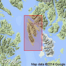
[Named for Chapin Peak]. Type locality: Chapin Peak-Downdraft Lake area, secs.12 and 13 T77S R90E, [Ketchikan quad] south Gravina Island, southeast Alaska. Crops out on west Gravina Island from Bostwick Inlet nearly to Vallenar Bay. Thickness varies from 500 to 1500 ft. Overlies Upper Triassic Nehenta Formation and elsewhere Paleozoic rocks; disconformably or unconformably underlies unnamed Upper Jurassic rocks. Mostly basaltic pillow flows and pyroclastic rocks that intertongue complexly with conglomerate and grit, siltstone and argillite, and limestone. Pillow flows average 10 ft thick, sedimentary beds 1 in to 3 ft; most rocks have distinct slaty cleavage; interstices between pillows commonly contain limestone; some aquagene tuff; some small bodies of altered basic intrusive rock enclosed by volcanic rocks. Contains Late Triassic marine fossils identified by N.J. Silberling and D.L. Jones that are probably late Norian in age [fossils not given].
Source: GNU records (USGS DDS-6; Menlo GNULEX).
- Usage in publication:
-
- Chapin Peak Formation*
- Modifications:
-
- Revised
- AAPG geologic province:
-
- Alaska Southeastern region
Summary:
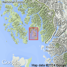
Chapin Peak Formation on Gravina Island included in Hyd Group which is geographically extended south to Gravina and Annette Islands. Assignment based on similar rock type, stratigraphic position, and age.
Source: GNU records (USGS DDS-6; Menlo GNULEX).
- Usage in publication:
-
- Chapin Peak Formation*
- Modifications:
-
- Areal extent
- AAPG geologic province:
-
- Alaska Southeastern region
Summary:
Chapin Peak Formation on Gravina Island included in Hyd Group which is geographically extended southward to include rocks on Gravina and Annette Islands.
Source: GNU records (USGS DDS-6; Menlo GNULEX).
For more information, please contact Nancy Stamm, Geologic Names Committee Secretary.
Asterisk (*) indicates published by U.S. Geological Survey authors.
"No current usage" (†) implies that a name has been abandoned or has fallen into disuse. Former usage and, if known, replacement name given in parentheses ( ).
Slash (/) indicates name conflicts with nomenclatural guidelines (CSN, 1933; ACSN, 1961, 1970; NACSN, 1983, 2005, 2021). May be explained within brackets ([ ]).