

- Usage in publication:
-
- Capitol Metabentonite
- Modifications:
-
- Named
- Dominant lithology:
-
- Bentonite
- Clay
- AAPG geologic province:
-
- Cincinnati arch
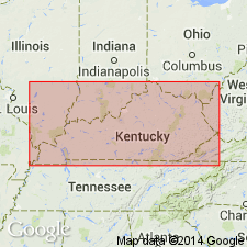
Summary:
Capitol Metabentonite, here named in Frankfort, KY, is described as easily identified intercalated clayey shale, limestone, dolomitic shale, shale, and silty dolomite. Maximum thickness is 3.45 ft. Unit occurs in middle of Curdsville Limestone of Trenton Group. Probably correlates with Millbrig K-bentonite at or near base of Glencoe Member of Spechts Ferry Formation.
Source: GNU records (USGS DDS-6; Reston GNULEX).
- Usage in publication:
-
- Capitol Metabentonite
- Modifications:
-
- Areal extent
- AAPG geologic province:
-
- Cincinnati arch
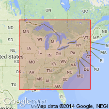
Summary:
Capitol Metabentonite is situated in the Curdsville-Logana, 8 to 13 ft above the late Blackriveran Tyrone-early Trentonian Curdsville paracontinuity in KY. Has also been recognized a few ft above the base of the early Trentonian Hermitage Formation of TN. In KY, unit is a 2- to 4-ft-thick interval of alternating metabentonitic clayey shales and intercalated flaggy, dolomitic limestone lenses. Unit correlates with the Hounsfield Metabentonite of NY and southern Ontario, CAN, and the Millbrig Metabentonite of MS.
Source: GNU records (USGS DDS-6; Reston GNULEX).
For more information, please contact Nancy Stamm, Geologic Names Committee Secretary.
Asterisk (*) indicates published by U.S. Geological Survey authors.
"No current usage" (†) implies that a name has been abandoned or has fallen into disuse. Former usage and, if known, replacement name given in parentheses ( ).
Slash (/) indicates name conflicts with nomenclatural guidelines (CSN, 1933; ACSN, 1961, 1970; NACSN, 1983, 2005, 2021). May be explained within brackets ([ ]).