

- Usage in publication:
-
- Cannery Formation*
- Modifications:
-
- Named
- Dominant lithology:
-
- Chert
- Argillite
- Graywacke
- AAPG geologic province:
-
- Alaska Southeastern region
Summary:
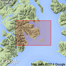
Named for exposures in and around mouth of Cannery Cove on southwest shore of Pybus Bay, southeastern coast of Admiralty Island, southeastern AK. Crops out almost continuously from point 3.5 mi southeast of Cannery Cove northwestward to north shore of Donkey Bay. Consists of thinly interbedded chert, argillite, and graywacke, and local intercalations of thick-bedded calcareous volcanic graywacke and altered pillow lavas and breccias. Is tightly folded. Overlies Hood Bay Formation (new) to southwest and Gambier Bay Formation (new) to north. Underlies Pybus Dolomite (new). Southwest of Pybus Bay, unit is buried unconformably beneath nonmarine sedimentary rocks of Tertiary age. Near Gambier Bay unconformably underlies Hyd Formation (new). Bryozoan debris in calcareous graywacke at several localities indicate age no older than Permian (Helen Duncan with L.G. Henbest, written commun., 1959, 1960). Shown on geologic map of Pybus-Gambier area as Permian age.
Source: GNU records (USGS DDS-6; Menlo GNULEX).
- Usage in publication:
-
- Cannery Formation*
- Modifications:
-
- Areal extent
- Age modified
- AAPG geologic province:
-
- Alaska Southeastern region
Summary:
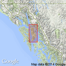
Shown on geologic map of Admiralty Island, southeastern AK. Cannery Formation of Loney (1964) is also to be found slightly metamorphosed and deformed on ridge southwest and west of Eagle Peak in northern part of Admiralty Island. On basis of fossils collected from northern Admiralty Island including brachiopod MUIRWOODIA unit is assigned Early Permian age.
Source: GNU records (USGS DDS-6; Menlo GNULEX).
- Usage in publication:
-
- Cannery Formation*
- Modifications:
-
- Areal extent
- AAPG geologic province:
-
- Alaska Southeastern region
Summary:
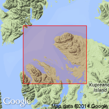
Shown on map and cross section of Keku Islets and neighboring parts of Kuiu and Kupreanof Islands, southeastern AK. Unconformably underlies Pybus Formation and locally Burnt Island Conglomerate and Hound Island Volcanics. Age is given as Early Permian (probably Leonard?) (J.T. Dutro, Jr., oral commun., 1963).
Source: GNU records (USGS DDS-6; Menlo GNULEX).
- Usage in publication:
-
- Cannery Formation*
- Modifications:
-
- Age modified
- AAPG geologic province:
-
- Alaska Southeastern region
Summary:
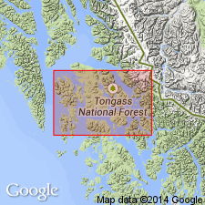
Age of Cannery Formation on Kupreanof and Keku Islands is Late Devonian and Early and Late Mississippian on basis of Famennian, Kinderhookian, and Chesterian marine microfossils (conodonts and foraminifers). Relation of Cannery Formation to Halleck Formation is discussed.
Source: GNU records (USGS DDS-6; Menlo GNULEX).
For more information, please contact Nancy Stamm, Geologic Names Committee Secretary.
Asterisk (*) indicates published by U.S. Geological Survey authors.
"No current usage" (†) implies that a name has been abandoned or has fallen into disuse. Former usage and, if known, replacement name given in parentheses ( ).
Slash (/) indicates name conflicts with nomenclatural guidelines (CSN, 1933; ACSN, 1961, 1970; NACSN, 1983, 2005, 2021). May be explained within brackets ([ ]).