

- Usage in publication:
-
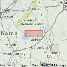
- Camp Hill Granite
- Modifications:
-
- Overview
- AAPG geologic province:
-
- Piedmont-Blue Ridge province
Summary:
Name Camp Hill Granite, suggested by Deininger and others (1969: GSA Abstract), is applied here to extensive outcrop areas of biotite-granite gneiss across the southern part of the Dadeville Complex. Typical exposures are found at Camp Hill, Tallapoosa Co., east-central AL. Gneisses range in composition from granites to quartz monzonites and contain biotite and muscovite in varying amounts. Many of the gneisses are biotite-rich and extremely foliated. Petrographically, the Camp Hill consists of biotite, microcline, oligoclase and quartz with apatite, zircon, and rutile as accessory minerals. Relationship to the Rock Mills granite, also of the Dadeville Complex, is unclear, but both appear to be continuous over wide areas and have homogeneous compositions. The Camp Hill appears to be dominantly a quartz monzonite while the Rock Mills granite-gneiss is almost true granite. They possibly represent a granite-gneiss "basement."
Source: GNU records (USGS DDS-6; Reston GNULEX).
- Usage in publication:
-
- Camp Hill Gneiss
- Modifications:
-
- Revised
- AAPG geologic province:
-
- Piedmont-Blue Ridge province
Summary:
Felsic rocks of the Dadeville Complex in the study area previously assigned to the Camp Hill granite by Bentley and Neathery (1970) and to the Camp Hill Granite Gneiss by Raymond and others (1988) are here subdivided into the Camp Hill Gneiss (revised) and the newly named Chattasofka Creek Gneiss. A new type locality is designated in Tallapoosa Co., 2.5 mi northeast of Camp Hill. The Camp Hill is medium to coarse grained, light gray when fresh, and characterized by a paucity of alkali feldspar. Composition is tonalitic. Contains less than 2 modal percent potassium feldspar and therefore should not be called a granite. Occurs as at least nine separate bodies over 16 sq. mi. Unit has not been isotopically dated but is younger than both the Agricola Schist and the Ropes Creek Amphibolite for it contains xenoliths of these units. Plutonism may represent the onset of the Acadian Orogeny, therefore considered Late Devonian.
Source: GNU records (USGS DDS-6; Reston GNULEX).
- Usage in publication:
-
- Camp Hill Gneiss*
- Modifications:
-
- Age modified
- AAPG geologic province:
-
- Piedmont-Blue Ridge province
Summary:
Inner Piedmont is divided into two groups of rocks, Dadeville and Opelika Complexes (Bentley and Neathery, 1970), divided by Stonewall line. Dadeville Complex consists of Agricola Schist, Waresville Schist, Camp Hill Gneiss, Chattasofka Creek Gneiss, Ropes Creek Amphibolite, Waverly Gneiss, Simmons Crossroads metagranite (informal), and various unnamed mafic and ultramafic intrusive rocks. Opelika Complex consists of Loachapoka Schist, Saugahatchee quartzite, and Auburn Gneiss and schist. Farmville Metagranite intrudes these units. Age of all Inner Piedmont rocks is early Paleozoic. Report includes geologic sketch map.
[Remark reflects usage as published, not as reviewed in draft form. Although GNU review requested informal terms to be inverted, the published version shows that authors did not comply with request. Whatley Mill is misspelled as Whatley Mills in published version; error introduced after GNU review (GNU records, USGS DDS-6; Reston GNULEX Jan. 21, 1994).]
Source: GNU records (USGS DDS-6; Reston GNULEX).
For more information, please contact Nancy Stamm, Geologic Names Committee Secretary.
Asterisk (*) indicates published by U.S. Geological Survey authors.
"No current usage" (†) implies that a name has been abandoned or has fallen into disuse. Former usage and, if known, replacement name given in parentheses ( ).
Slash (/) indicates name conflicts with nomenclatural guidelines (CSN, 1933; ACSN, 1961, 1970; NACSN, 1983, 2005, 2021). May be explained within brackets ([ ]).