

- Usage in publication:
-
- Camden chert*
- Modifications:
-
- Original reference
- Dominant lithology:
-
- Chert
- AAPG geologic province:
-
- Cincinnati arch
- Upper Mississippi embayment
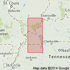
Summary:
Pg. 429-430. Camden chert. Chert, exposed to a thickness of 60 feet at Camden, Benton County, western Tennessee, containing a Lower Oriskany fauna. Overlies Lower Helderberg shaly bluish limestone [Linden formation]. Occurs also in Henry, Decatur, and Stewart Counties. [Subsequent reports by Safford applied Camden chert to all beds in Tennessee between Hardin sandstone and Linden formation, and assigned it to Oriskany.] Age is Middle Devonian.
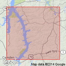
[Named from exposures along Cypress Creek, southeast of Camden, Benton Co., western TN.]
Source: US geologic names lexicon (USGS Bull. 896, p. 323).
- Usage in publication:
-
- Camden chert*
- Modifications:
-
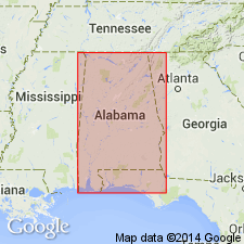
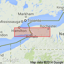
- Areal extent
- AAPG geologic province:
-
- Upper Mississippi embayment
Summary:
Camden chert extended into AL. Uses nomenclature as revised by Dunbar (1918).
Source: GNU records (USGS DDS-6; Reston GNULEX).

- Usage in publication:
-
- Camden chert*
- Modifications:
-
- Revised
- Age modified
- AAPG geologic province:
-
- Cincinnati arch
- Upper Mississippi embayment
Summary:
In 1918 (Amer. Jour. Sci., 4th ser., v. 46, p. 732-755) C.O. Dunbar restricted Camden chert to upper 200 feet of beds to which it had formerly been applied, and subdivided the lower part into Harriman chert (0 to 55 feet thick), underlain by Quail limestone (0 to 10 feet thick), underlain by Decaturville chert (0 to 6 feet thick). According to Dunbar the restricted Camden chert is of Onondaga age, the Harriman and Quail are of Oriskany age, and Decaturville chert is of Helderberg age, and the four formations are unconformable one with the other and also unconformable with both underlying and overlying formations, the Camden chert being unconformably overlain by Pegram limestone and Decaturville chert unconformably underlain by rocks of earlier Helderberg age to which Dunbar has applied name Birdsong formation.
Source: US geologic names lexicon (USGS Bull. 896, p. 323).
- Usage in publication:
-
- Camden chert
- Modifications:
-
- Age modified
- AAPG geologic province:
-
- Cincinnati arch
- Upper Mississippi embayment
Summary:
Chart 4. Age shown on correlation chart as Early or Middle Devonian.
Source: US geologic names lexicon (USGS Bull. 1200, p. 590).
- Usage in publication:
-
- Camden formation
- Modifications:
-
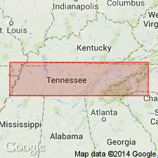
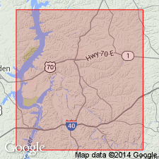
- Areal extent
- AAPG geologic province:
-
- Cincinnati arch
Summary:
Pg. 310-312 [p. 317-320 of 1990 ed.]. Camden formation. Consists of two contemporaneous phases of limestone and chert. Thickness 14 to 164 feet. Unconformably overlies Harriman formation; unconformably underlies Pegram formation at exposure near mouth of Standing Rock Creek and at the Whirl of Buffalo River; elsewhere underlies Chattanooga shale or Eutaw sand. Age is Middle Devonian.
Source: Publication; US geologic names lexicon (USGS Bull. 1200, p. 590).
- Usage in publication:
-
- Camden chert
- Modifications:
-
- Areal extent
- AAPG geologic province:
-
- Upper Mississippi embayment
Summary:
Only known exposure of Camden chert in KY is in narrow, northeast-trending fault block 0.25 mi long, 0.4 mi south of Little Bear Creek on west side of Kentucky Lake, and 4.5 mi above Kentucky Dam, near Aurora, Marshall Co.
Source: GNU records (USGS DDS-6; Reston GNULEX).
- Usage in publication:
-
- Camden Chert*
- Modifications:
-
- Biostratigraphic dating
- AAPG geologic province:
-
- Upper Mississippi embayment
- Cincinnati arch
Summary:
Bois Blanc brachiopods indicate correlation with Schoharie Formation of NY and its equivalents elsewhere. Correlation chart indicates a late Early Devonian age for Camden Chert. Brachiopods were examined from Camden Chert in western TN (from Dunbar, 1919) and from western KY (from Luttrell and Livesay, 1952).
Source: GNU records (USGS DDS-6; Reston GNULEX).
- Usage in publication:
-
- Camden Formation*
- Modifications:
-
- Biostratigraphic dating
- AAPG geologic province:
-
- Cincinnati arch
Summary:
Camden Formation occurs in du Pont Geohydrological Survey well near Waverly, Humphreys Co., central TN. Presence of conodont ICRIODUS CLAUDIAE in uppermost Camden suggests an age no younger than Pragian here. Camden ranges from late Lochkovian to early Emsian in west-central TN, but age of the top of the formation varies along pre-Chattanooga Shale erosion surface.
Source: GNU records (USGS DDS-6; Reston GNULEX).
For more information, please contact Nancy Stamm, Geologic Names Committee Secretary.
Asterisk (*) indicates published by U.S. Geological Survey authors.
"No current usage" (†) implies that a name has been abandoned or has fallen into disuse. Former usage and, if known, replacement name given in parentheses ( ).
Slash (/) indicates name conflicts with nomenclatural guidelines (CSN, 1933; ACSN, 1961, 1970; NACSN, 1983, 2005, 2021). May be explained within brackets ([ ]).