

- Usage in publication:
-
- Cades conglomerate*
- Modifications:
-
- Original reference
- Dominant lithology:
-
- Slate
- Sandstone
- Graywacke
- Conglomerate
- AAPG geologic province:
-
- Appalachian basin
- Piedmont-Blue Ridge province
Summary:
Pg. 2. Cades conglomerate [of Chilhowee group]. Thick beds of slate, sandstone, graywacke, and conglomerate. The beds of fine slate are black and grayish black; the other beds are of various shades of gray. Few beds are over 50 feet thick, most of them being from 6 inches to 3 feet thick. Thickness of formation probably 2,400 feet. Overlies Pigeon slate and underlies Thunderhead conglomerate. Age is Early Cambrian.
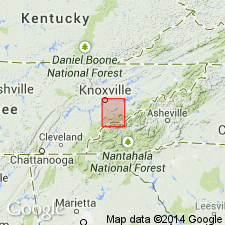
[Named from exposures near Cade Cove (spelled Cade Cove on atlas sheet), Blount Co., eastern TN. Extends into western NC.]
Source: US geologic names lexicon (USGS Bull. 896, p. 313).
- Usage in publication:
-
- Cades sandstone*
- Modifications:
-
- Revised
- Age modified
- AAPG geologic province:
-
- Appalachian basin
- Piedmont-Blue Ridge province
Summary:
Revised as Cades sandstone in Ocoee series. Keith (1895) mapped Cades north and south of Cades Cove and elsewhere in the mountains; the name is here restricted to rocks mainly north and west of Cades Cove and south of and beneath the Greenbrier fault. Age is changed to later Precambrian. Resembles more closely the Great Smoky group rather than the Snowbird group, but it differs from Elkmont and Thunderhead sandstones of Great Smoky group which adjoin it south of Cades Cove.
Source: GNU records (USGS DDS-6; Reston GNULEX).
- Usage in publication:
-
- Cades sandstone*
- Modifications:
-
- Overview
- AAPG geologic province:
-
- Appalachian basin
Summary:
Cades sandstone is not shown in report area, but may be correlative with unnamed rocks of Webb Mountain and Big Ridge (probably also correlative with Rich Butt sandstone) and Metcalf phyllite of Snowbird group outside of map area in western foothills, according to R.B. Neuman. Age is late Precambrian. Report includes geologic map, cross sections, correlation chart, and measured sections.
Source: GNU records (USGS DDS-6; Reston GNULEX).

- Usage in publication:
-
- Cades Sandstone
- Modifications:
-
- Overview
- AAPG geologic province:
-
- Appalachian basin
Summary:
In Unaka Mountains of eastern TN, used as Cades Sandstone of Precambrian age.
Source: GNU records (USGS DDS-6; Reston GNULEX).
- Usage in publication:
-
- Cades Sandstone*
- Modifications:
-
- Overview
- Areal extent
- AAPG geologic province:
-
- Piedmont-Blue Ridge province
- Appalachian basin
Summary:
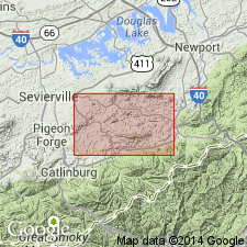
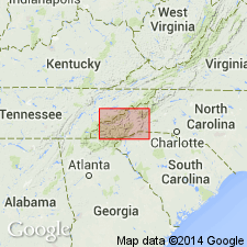
Included in Ocoee Series. Mapped undivided with Rich Butt Sandstone and sandstone of Big Ridge in Blue Ridge belt, northwest of Greenbrier-Devils Fork fault. Occurs southwest of Pigeon River in Blount, Sevier, and Cocke Cos., eastern TN, and in Haywood Co., northwestern NC. Collectively described in southwest part of mapped area as mainly gray, coarse- to medium-bedded sandstone, highly feldspathic, in graded beds 1 to 4 ft thick, interbedded with dark-gray argillite and siltstone. Locally includes granite boulder conglomerate beds 5 to 15 ft thick. Upper part of unit in central areas is mainly coarse feldspathic sandstone in thick graded beds. In northeastern part of area, mainly medium- to fine-grained feldspathic sandstone, in part indistinctly current bedded, with sharply defined layers and laminae of dark argillite or slate. Age is late Precambrian.
Source: GNU records (USGS DDS-6; Reston GNULEX).
For more information, please contact Nancy Stamm, Geologic Names Committee Secretary.
Asterisk (*) indicates published by U.S. Geological Survey authors.
"No current usage" (†) implies that a name has been abandoned or has fallen into disuse. Former usage and, if known, replacement name given in parentheses ( ).
Slash (/) indicates name conflicts with nomenclatural guidelines (CSN, 1933; ACSN, 1961, 1970; NACSN, 1983, 2005, 2021). May be explained within brackets ([ ]).