

- Usage in publication:
-
- Butterfield formation
- Modifications:
-
- First used
- Dominant lithology:
-
- Limestone
- AAPG geologic province:
-
- Wasatch uplift
- Great Basin province
Summary:
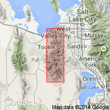
First published use as a name for the middle formation of the Oquirrh group (rank raised; restricted to Pennsylvanian-age rocks). Intent to name not stated. Type section is in secs 10, 15, T4S, R3W, Salt Lake Co, UT on the Wasatch uplift. Includes 9 mappable limestones, the Ribbon, Step, Billiard Ball, Fern, G. J., G. C., Highland, Saint Joe, Sub Jordan [all informal? mining terms]. The "Billiard Ball" is a gray to black, very fine grained, thin-bedded to platy limestone with silt stringers and rounded globular black chert nodules. [Lithologies present between the limestones --sandstone?--not discussed.] Cross section. Mapped (geologic map) in south part of map area in Salt Lake Co (Wasatch uplift) and in Tooele Co (Great Basin province). Of Middle Pennsylvanian, Desmoinesian age. The fusulinid FUSULINA occurs in many of the limestone beds. Overlies White Pine formation (first used), basal formation of Oquirrh group. Underlies Bingham Mine formation (named) of Oquirrh.
Source: GNU records (USGS DDS-6; Denver GNULEX).
- Usage in publication:
-
- Butterfield Formation
- Modifications:
-
- Not used
Summary:
Rocks assigned to Butterfield Formation of the Oquirrh Group by Welsh and James (1961) are included with their White Pine Formation into the newly named Butterfield Peaks Formation of the Oquirrh Group.
These rocks formerly were believed to represent the upper part of the Maple Formation and all of the "White Pine" and Butterfield Formations of Welsh and James (1961) (fig. 5).
Butterfield Limestone Member abandoned. Its rocks included in Butterfield Peaks Formation (new).
Butterfield Peaks Formation adopted as middle formation of three in the Oquirrh Group in Bingham sequence, central and southern Oquirrh Mountains, Tooele County, Utah (Great Basin province). Overlies West Canyon Limestone; underlies Bingham Mine Formation.
Source: GNU records (USGS DDS-6; Denver GNULEX).
For more information, please contact Nancy Stamm, Geologic Names Committee Secretary.
Asterisk (*) indicates published by U.S. Geological Survey authors.
"No current usage" (†) implies that a name has been abandoned or has fallen into disuse. Former usage and, if known, replacement name given in parentheses ( ).
Slash (/) indicates name conflicts with nomenclatural guidelines (CSN, 1933; ACSN, 1961, 1970; NACSN, 1983, 2005, 2021). May be explained within brackets ([ ]).