

- Usage in publication:
-
- Burnt Canyon limestone
- Burnt Canyon formation
- Modifications:
-
- Original reference
- AAPG geologic province:
-
- Great Basin province
- South Western Overthrust
Summary:
Pg. 36-38, fig. 5. Burnt Canyon limestone, Burnt Canyon formation. Dark-gray to black, thin- to medium-bedded limestone. Previously termed basal or "C" unit of Highland Peak limestone as restricted by Wheeler (1940). Recognition of overlying Dome and Swasey limestones in the Highland Peak requires that unit be given formational rank. Thickness 225 to 420 feet. Overlies Burrows limestone; conformably underlies Dome limestone. In House Range, Utah, formation consists of uppermost 225 feet of Howell limestone as emended by Deiss (1938). Age is late Middle Cambrian based on fossils [trilobites].
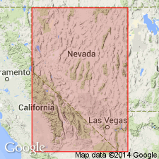
Named from typical exposures in Burnt Canyon on west slope of Highland Range, Pioche district, southeastern NV.
Type section: on west side of Highland Range on crest of spur between Peasley [Peaslee] Canyon and Burnt Canyon, Pioche district, [in secs. 28, 29, 32, and 33, T. 1 N., R. 66 E., Highland Peak 7.5-min quadrangle], Lincoln Co., southeastern NV (see Merriam and Palmer, 1964).
Source: US geologic names lexicon (USGS Bull. 1200, p. 546); GNU records (USGS DDS-6; Menlo GNULEX).
- Usage in publication:
-
- Burnt Canyon formation
- Modifications:
-
- Revised
- AAPG geologic province:
-
- Great Basin province
Summary:
Pg. 12 (table 1), 35, 45-46, pl. 1, measured sections. Burnt Canyon formation of Ophir group. Included in Ophir group in Sheeprock Mountains, western Utah, where it overlies Millard formation and underlies Dome limestone. Thickness 178 to 221 feet. Basal 21 feet may represent Burrows limestone. Age is middle Middle Cambrian, based on stratigraphic position.
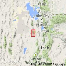
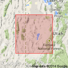
[Mapped in area south of Lookout Peak (now Red Pine Mountain), in T. 9 S., R. 6 and 7 W., Lookout Pass 7.5-min quadrangle, Wasatch National Forest, Tooele Co., western UT.]
Source: Publication; US geologic names lexicon (USGS Bull. 1200, p. 546).
- Usage in publication:
-
- Burnt Canyon limestone
- Modifications:
-
- Not used
- AAPG geologic province:
-
- Great Basin province
- South Western Overthrust
Summary:
Pg. 49, 50 (fig. 4). Burnt Canyon limestone not used. Proposed that name Chisholm be applied to unit in House Range, [central western Utah], that Wheeler (1948) designated as Burnt Canyon limestone. Correlation chart (fig. 4) shows Wheeler's Burnt Canyon in Wah Wah Range, [southern western Utah], replaced with Whirlwind (new) and Swasey formations; in Pioche district, [southeastern Nevada], Wheeler's Burnt Canyon is replaced with part of Burrows formation, Whirlwind formation, and lower part of Highland Peak formation. [Middle Cambrian.]
Source: US geologic names lexicon (USGS Bull. 1200, p. 547).
- Usage in publication:
-
- Burnt Canyon Member*
- Modifications:
-
- Revised
- Adopted
- AAPG geologic province:
-
- Great Basin province
Summary:
Pg. 34 (table 5), 41-43. Burnt Canyon Member of Highland Peak Formation. Dark-gray well-bedded fossiliferous limestone in lower part of Highland Peak Formation, below Step Ridge Member and above Burrows Member. Average thickness 190 feet in Pioche mining district, Nevada. Previously called "Highland Peak C" by Wheeler and Lemmon (1939), "Burnt Canyon Limestone" by Wheeler (1948), and "Black Davidson lime" by mining companies. [Restricted from Utah.] Burnt Canyon Limestone of House Range (Wheeler, 1948) is here considered correlative with Chisholm Shale (A.R. Palmer, 1956, Cambrian of Great Basin, 20th Intl. Geol. Cong.). The Ely Range true Burnt Canyon Member seemingly correlates with shaly lower part of Swasey Formation in House Range, to which Wheeler erroneously applied name "Condor [Member]." [See also entry under Condor.] Fossils; carries KOOTENIA sp. and ptychoparioid trilobites. Age is Middle Cambrian.
[Burnt Canyon Member of Highland Peak Formation, as recognized in Pioche district, Lincoln Co., NV, adopted by the USGS (GNC index card files, USGS-Menlo, USGS-Reston; GNC changes in geologic nomenclature, unpub., Jan. 1, 1962-June 30, 1962, p. 13).]
Source: Publication; GNU records (USGS DDS-6; Menlo GNULEX); GNC index card files (USGS-Menlo; USGS-Reston).
For more information, please contact Nancy Stamm, Geologic Names Committee Secretary.
Asterisk (*) indicates published by U.S. Geological Survey authors.
"No current usage" (†) implies that a name has been abandoned or has fallen into disuse. Former usage and, if known, replacement name given in parentheses ( ).
Slash (/) indicates name conflicts with nomenclatural guidelines (CSN, 1933; ACSN, 1961, 1970; NACSN, 1983, 2005, 2021). May be explained within brackets ([ ]).