The National Geologic Map Database is migrating to a new infrastructure. We apologize for any service disruptions during this process.
|
|---|


- Usage in publication:
-
- Budden Canyon Formation
- Modifications:
-
- Named
- Dominant lithology:
-
- Sandstone
- Siltstone
- Mudstone
- AAPG geologic province:
-
- Sacramento basin
Summary:
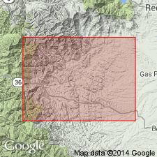
Term Budden Canyon Formation proposed to include those rocks of Ono and Chanchelulla Peak 15' quads that lie above igneous and metamorphic rocks of Klamath Mountains complex and are unconformably overlain by Tehama (Pliocene) and Red Bluff (Pleistocene) Formations. Type section designated as exposures along State Route 36 (Dry Creek-Budden Canyon) from secs.35-36 T29N R8W to sec.18 T28N R6W, Ono 15' quad Tehama Co, CA. Consists of thick succession of medium to dark-gray sandstones, siltstones and mudstones, and minor amounts of conglomerate. Total thickness estimated at 22,000 ft. Divided into seven members: Rector Conglomerate, Ogo (new), Roaring River, Chickabally Mudstone (new), Huling Sandstone, Bald Hills and Gas Point (new) Members. Thickness ranges from 7,400 to 22,000 ft. Ranges in age from Hauterivian to Turonian [Early to Late Cretaceous] based on fossils. Ono Formation (Murphy, 1956) is abandoned in this report.
Source: GNU records (USGS DDS-6; Menlo GNULEX).
- Usage in publication:
-
- Budden Canyon Formation
- Modifications:
-
- Revised
- Overview
- AAPG geologic province:
-
- Sacramento basin
Summary:
Upper part of Chickabally Mudstone Member of Murphy and others (1960) here renamed Aiken Member (new) of Budden Canyon Formation. Lower part is now Chickabally Member, its type section likewise restricted to 900 ft along Roaring River in secs.32-33 T30N R7W. Biostratigraphic study of foraminifers especially in Chickabally and Aiken Members. Geologic maps of portion of Ono quad show distribution of members.
Source: GNU records (USGS DDS-6; Menlo GNULEX).
For more information, please contact Nancy Stamm, Geologic Names Committee Secretary.
Asterisk (*) indicates published by U.S. Geological Survey authors.
"No current usage" (†) implies that a name has been abandoned or has fallen into disuse. Former usage and, if known, replacement name given in parentheses ( ).
Slash (/) indicates name conflicts with nomenclatural guidelines (CSN, 1933; ACSN, 1961, 1970; NACSN, 1983, 2005, 2021). May be explained within brackets ([ ]).