

- Usage in publication:
-
- Brothers Volcanics*
- Modifications:
-
- Named
- Dominant lithology:
-
- Volcanics
- Breccia
- AAPG geologic province:
-
- Alaska Southeastern region
Summary:
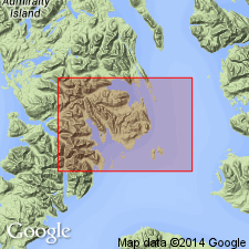
Named for sequence of andesitic volcanic flows, breccias, and associated volcanic sedimentary rocks on The Brothers Islands, southeastern part of Pybus-Gambier area. Flows are chiefly dark gray, purplish gray, dark greenish-gray, rarely medium gray, and weather light green, dark green, and yellowish olive. Is at least 2000 ft thick. Seems to be conformable on Seymour Canal Formation as shown by contact on West Brother Island. Composite stratigraphic section shows unit may also interfinger with upper part of Seymour Canal Formation. Shown on geologic map of Pybus-Gambier area, Admiralty Island, AK. Underlies with angular unconformity unnamed conglomerate and sandstone of Tertiary age. Is Late Jurassic and Early Cretaceous age based on stratigraphic relations.
Source: GNU records (USGS DDS-6; Menlo GNULEX).
- Usage in publication:
-
- Brothers Volcanics*
- Modifications:
-
- Revised
- AAPG geologic province:
-
- Alaska Southeastern region
Summary:
Assigned as uppermost formation in Stephens Passage Group (new). Brothers Volcanics is similar lithologically to Douglas Island Volcanics (Stephens Passage Group). Brothers Volcanics may prove to be either lens in Seymour Canal Formation (Stephens Passage Group) or equivalent to Douglas Island Volcanics as southern continuation of its outcrop belt. Mapped with Douglas Island Volcanics in this report.
Source: GNU records (USGS DDS-6; Menlo GNULEX).
For more information, please contact Nancy Stamm, Geologic Names Committee Secretary.
Asterisk (*) indicates published by U.S. Geological Survey authors.
"No current usage" (†) implies that a name has been abandoned or has fallen into disuse. Former usage and, if known, replacement name given in parentheses ( ).
Slash (/) indicates name conflicts with nomenclatural guidelines (CSN, 1933; ACSN, 1961, 1970; NACSN, 1983, 2005, 2021). May be explained within brackets ([ ]).