The National Geologic Map Database is migrating to a new infrastructure. We apologize for any service disruptions during this process.
|
|---|


- Usage in publication:
-
- Bridal Veil limestone member*
- Modifications:
-
- Named
- Dominant lithology:
-
- Limestone
- AAPG geologic province:
-
- Wasatch uplift
Summary:
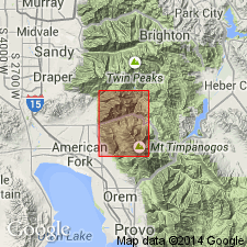
Bridal Veil limestone member of Oquirrh formation. Mapped in the south-central and north-central part of Timpanogos Cave quadrangle. Is a medium- to dark-gray limestone about 1,200 feet thick at base of Oquirrh formation. Underlies main body of the Oquirrh, a fine- to medium-grained, thin- to thick-bedded, tan-weathering sandstone and quartzite. Overlies Manning Canyon shale. Appears to be equivalent to West Canyon limestone member (Nygreen, 1958) of Oquirrh of the southernmost Oquirrh Mountains. Age is Pennsylvanian; contains fossils of Early Pennsylvanian age. Report includes geologic map, cross sections.
Named from Bridal Veil Falls, on south side of Provo Canyon in sec. 34, T. 5 S., R. 3 E., Utah Co., northern UT (Wasatch uplift).
Source: US geologic names lexicon (USGS Bull. 1350, p. 90); GNU records (USGS DDS-6; Denver GNULEX).
- Usage in publication:
-
- Bridal Veil Limestone Member*
- Modifications:
-
- Areal extent
- AAPG geologic province:
-
- Wasatch uplift
Summary:
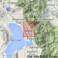
(map with text). Bridal Veil Limestone Member of Oquirrh Formation. Mapped in Orem quadrangle. Crops out in cliff extending across northeast corner of quadrangle along side of range but is partially obscured by allochthonous mass of quartzite that extends from south of Provo River to north edge of quadrangle. Contains abundant fossils including MILLERELLA sp. Bissell (1959) applied name Hall Canyon Member to the unit in Oquirrh Mountains. Note on type locality.
Type locality: Bridal Veil Falls, on south side of Provo Canyon in sec. 34, T. 5 S., R. 3 E., about 2.75 mi southeast of southeast corner of Timpanogos Cave quadrangle, Utah Co., northern UT (Wasatch uplift).
Source: US geologic names lexicon (USGS Bull. 1350, p. 90).
- Usage in publication:
-
- Bridal Veil Limestone Member
- Modifications:
-
- Not used
Summary:
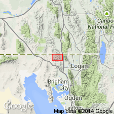
Name West Canyon Limestone Member used in preference to Bridal Veil for the basal limestone of the Oquirrh Formation at Samaria Mountain, Oneida County, Idaho (Great Basin province). West Canyon has priority. Occurs from northernmost Utah into southern Idaho. These two names have been applied to the same unit.
Source: Modified from GNU records (USGS DDS-6; Denver GNULEX).
- Usage in publication:
-
- Bridal Veil Falls Limestone Member
- Modifications:
-
- Overview
- AAPG geologic province:
-
- Wasatch uplift
Keroher, G.C., 1970, [Selected U.S. Geologic Names Committee remarks]: U.S. Geological Survey Bulletin, 1350, 848 p.
Summary:
Bridal Veil Falls Member of Oquirrh Formation. Probably lapsus for Bridal Veil Limestone Member of Oquirrh Formation.
Source: US geologic names lexicon (USGS Bull. 1350, p. 90).
- Usage in publication:
-
- Bridal Veil Limestone Member*
- Modifications:
-
- Areal extent
- Age modified
- AAPG geologic province:
-
- Wasatch uplift
Summary:
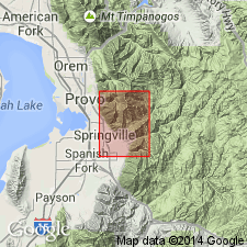
(map and text). Bridal Veil Limestone Member, basal member of Oquirrh Formation. [Mapped southeast of where Bridal Veil was originally described; crops out just northeast of town of Springville and in two areas along northern edge of quadrangle.] Is a 1,245 feet thick, dark-gray to black, thin- to thick-bedded, fossiliferous, cherty limestone with local beds of quartzite. Occurs below lower sandy member of Oquirrh and above Manning Canyon Shale. Age is modified from Early Pennsylvanian --to-- Early and Middle Pennsylvanian (Atokan and older); [assigned an Early Pennsylvanian age in text]. Report includes cross sections.
Source: Map legend; Changes in stratigraphic nomenclature, 1974 (USGS Bull. 1405-A, p. A4-A5); supplemental information (in brackets) from GNU records (USGS DDS-6; Denver GNULEX).
- Usage in publication:
-
- Bridal Veil Falls Limestone
- Modifications:
-
- Overview
- AAPG geologic province:
-
- Wasatch uplift
Summary:
Pg. 34-35 (fig. 40), 36, 151 (chart 35). Bridal Veil Falls Limestone. Is basal limestone unit of the Oquirrh Group in Provo, Utah Valley, and Wallburg area, southern Wasatch Mountains; thickness 1,050 feet thick. Is the easiest unit of the Oquirrh to trace, not only because it is mostly limestone, but also because it bears a prolific fauna of brachiopods, corals, bryozoans, and other organisms that make it readily identifiable. Equivalent to West Canyon Limestone of the Oquirrh Mountains. Conformably underlies Bear Canyon Formation (Atokan-Desmoinesian) of Oquirrh and conformably overlies Manning Canyon Shale. Age is Early Pennsylvanian (Morrowan); MILLERELLA fusulinid zone; Morrowan fossil brachiopods, corals, bryozoans abundant. Davis [and Webster] (1987, GSA Abs. with Prog., v. 19, p. 269; complete paper (in press) in Compte Rendu, 11th Intl. Cong. Carbonif. Strat. and Geol., Beijing) have proposed that Morrowan limestones at north end of the Oquirrh Mountains could serve as a stratotype for the Miss-Penn boundary, based on conodonts.
Additional references cited (not synopsized to date):
Maxfield, E.B., 1957, Sedimentation and stratigraphy of the Morrowan Series in central Utah: Brigham Young Unversity Geology Studies, v. 4, no. 1, 46 p.;
Murphy, D.R., 1954, Fauna of the Morrowan rocks of central Utah: Brigham Young Univ. Geol. Studies, v. 1, no. 3, 64 p.
Alexander, D.W., 1978, Petrology and petrography of the Bridal Veil Limestone Member of the Oquirrh Formation at Cascade Mountain, Utah: Brigham Young Univ. Geol. Studies, v. 25, pt. 3, p. 11-26.
Welsh, J.E., and Bissell, H.J., 1979, The Mississippian and Pennsylvanian (Carboniferous) Systems in the United States: USGS Prof. Paper 1110-Y, 35 p.;
Welsh, letter, 1985.
Source: Publication.
For more information, please contact Nancy Stamm, Geologic Names Committee Secretary.
Asterisk (*) indicates published by U.S. Geological Survey authors.
"No current usage" (†) implies that a name has been abandoned or has fallen into disuse. Former usage and, if known, replacement name given in parentheses ( ).
Slash (/) indicates name conflicts with nomenclatural guidelines (CSN, 1933; ACSN, 1961, 1970; NACSN, 1983, 2005, 2021). May be explained within brackets ([ ]).