

- Usage in publication:
-
- Bootlegger member*
- Modifications:
-
- Original reference
- Dominant lithology:
-
- Sandstone
- Siltstone
- Shale
- AAPG geologic province:
-
- Sweetgrass arch
Summary:
Pg. 89 (fig. 1), 90. Bootlegger member of Blackleaf formation. Predominantly interbedded medium-gray sandstone, gray siltstone, and dark-gray shale; massive sandstone at base. A few thin layers of chert-pebble conglomerate present. Beds of bentonite common in upper half of member and one bed attains thickness of 10 feet. Widespread thin sandstone at top, in which finely fragmented fish bones are very abundant, is diagnostic feature. Thickness 330 feet in composite type section. Overlies Vaughn bentonitic member (new); underlies Floweree member (new) of Marias River shale (new). [Age is Early Cretaceous (late Albian).]
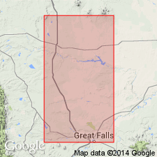
Composite type section: begins near place where Bootlegger Trail crosses outcrop of member at northeast corner sec. 1, T. 21 N., R. 3 E., [Great Falls 15-min quadrangle], Cascade Co., northwestern MT, and extends westward for about 15 mi toward Muddy Creek along upper part of a south-facing escarpment to sec. 13, T. 22 N., R. 1 W., [Teton Co., Vaughn 15-min quadrangle, northwestern MT]. Named from Bootlegger Trail, a secondary road extending from Great Falls north toward Canada.
Source: Publication; US geologic names lexicon (USGS Bull. 1200, p. 431).
- Usage in publication:
-
- Bootlegger Member*
- Modifications:
-
- Overview
- AAPG geologic province:
-
- Sweetgrass arch
Summary:
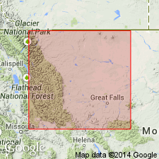
Is upper member of Blackleaf Formation of Colorado Group. Is a unit of marine origin correlated with upper part of Mowry Shale. A composite type section measured and described where member is 100 m thick, overlies Vaughn Member of Blackleaf and underlies Floweree Member of Marias River Shale. Outcrops of Bootlegger restricted to central part of Kevin-Sunburst dome. Contains fish scales also common to Mowry Shale. Correlated with Mowry of Black Hills. Contains an ammonite NEOGASTROPLITES that ranges from latest Albian to early Cenomanian, or Early and Late Cretaceous.
Source: GNU records (USGS DDS-6; Denver GNULEX).
- Usage in publication:
-
- Bootlegger Member*
- Modifications:
-
- Not used
Summary:
Bootlegger Member of the Blackleaf Formation not recognized in southwest MT, Montana folded belt province, by authors.
Source: GNU records (USGS DDS-6; Denver GNULEX).
- Usage in publication:
-
- Bootlegger Member*
- Modifications:
-
- Areal extent
- AAPG geologic province:
-
- Montana folded belt
Summary:
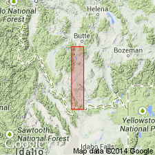
Lithologies of Bootlegger or Taft Hill Members of Blackleaf Formation not recognized in study area which extends from Lima Peaks area to eastern Pioneer Mountains, MT, Montana folded belt province. Here Blackleaf consists of Flood and Vaughn Members.
Source: GNU records (USGS DDS-6; Denver GNULEX).
For more information, please contact Nancy Stamm, Geologic Names Committee Secretary.
Asterisk (*) indicates published by U.S. Geological Survey authors.
"No current usage" (†) implies that a name has been abandoned or has fallen into disuse. Former usage and, if known, replacement name given in parentheses ( ).
Slash (/) indicates name conflicts with nomenclatural guidelines (CSN, 1933; ACSN, 1961, 1970; NACSN, 1983, 2005, 2021). May be explained within brackets ([ ]).