The National Geologic Map Database is migrating to a new infrastructure. We apologize for any service disruptions during this process.
|
|---|


- Usage in publication:
-
- Blocher formation
- Modifications:
-
- Named
- Dominant lithology:
-
- Shale
- Sandstone
- AAPG geologic province:
-
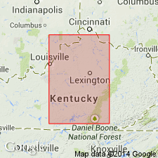
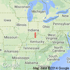
- Cincinnati arch
Summary:
Name Blocher formation proposed in Scott County, southeastern Indiana, for thinly laminated black shale that locally contains sandstone lenses 0.5 to 1.0 inches. thick in basal part. Fossils: conodonts. Commonly 8 to 10 feet thick, but ranges from 2 to 15 feet. Locally includes an additional bed at top, 1 to 3 feet thick, composed of black shale and layers of sandstone. At type locality overlies Swanville limestone; elsewhere overlies limestone of Hamilton age. Disconformably underlies Blackiston formation (new). Blocher is part of New Albany shale. Age is Middle Devonian.
Source: GNU records (USGS DDS-6; Reston GNULEX).
- Usage in publication:
-
- Blocher member
- Modifications:
-
- Revised
- AAPG geologic province:
-
- Cincinnati arch
Summary:
Indiana Geological Survey uses term Blocher member of New Albany shale.
Source: GNU records (USGS DDS-6; Reston GNULEX).
- Usage in publication:
-
- Blocher Shale
- Modifications:
-
- Revised
- AAPG geologic province:
-
- Cincinnati arch
Summary:
Blocher Shale is here stratigraphically restricted. Type section is redefined and part of strata is assigned to Selmier Shale. Blocher grades laterally into Sweetland Creek Shale. Overlies Lingle Formation of Hunton Megagroup; underlies Sylamore Sandstone. Age is mostly Middle Devonian.
Source: GNU records (USGS DDS-6; Reston GNULEX).
- Usage in publication:
-
- Blocher Member
- Modifications:
-
- Revised
- AAPG geologic province:
-
- Cincinnati arch
Summary:
Revision of Albany, Ohio, and Chattanooga based primarily on paracontinuities and associated bone beds. Olentangy Shale is assigned to New Albany Group and divided into upper Selmier Member and lower Blocher Member. Correlates with the Genesee of NY, the Little Rock Creek of northern IN, the lower Ohio Shale of OH and northeastern KY, and the lower Chattanooga of TN. The Middle-Late Devonian boundary is placed at the base of the Blocher.
Source: GNU records (USGS DDS-6; Reston GNULEX).
- Usage in publication:
-
- Blocher Member
- Modifications:
-
- Areal extent
- AAPG geologic province:
-
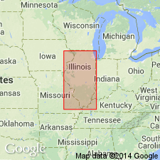
- Illinois basin
Summary:
Authors follow de Witt (1981) in restricting the New Albany Shale to the Illinois basin and the Ohio Shale to the Appalachian basin. Ohio Shale terminology used wherever Three Lick Bed is recognizable in cores. Unlike de Witt (1981), authors do not use Chattanooga Shale in Knobs outcrop area of south-central KY. Most of New Albany correlates with the Huron Member of Ohio Shale. Upper 1 to 2 m correlates with Cleveland Member. New Albany subdivided into (ascending) Blocher, Morgan Trail, Camp Run, and Clegg Creek Members.
Source: GNU records (USGS DDS-6; Reston GNULEX).
- Usage in publication:
-
- Blocher Member, Shale
- Modifications:
-
- Overview
- AAPG geologic province:
-
- Illinois basin
Summary:
Report summarizes the stratigraphic interpretations made by the Illinois, Indiana, and Kentucky Geological Surveys during the Eastern Gas Shales Project. Blocher (Member in IN and KY and Shale in IL) is distinct because it is the only brownish-black shale unit that contains much calcite. Basal part of the Blocher in the outcrop area of southeastern IN contains great concentrations of randomly distributed carbonate grains. Dark-grayish-brown carbonate concretions are also present. A thin phosphatic sandstone or bone bed at the base of the Blocher contains quartz, phosphatic nodules, rock fragments, fishbones and teeth, conodonts, and abundant pyrite. Unit is easily traced because of the moderately high concentrations of carbonate minerals and the low concentrations of radioactive elements, which give the Blocher a distinctive geophysical character. In IN, Blocher ranges in thickness from less than 5 ft along the outcrop belt in southeastern IN to 67 ft in the subsurface of Posey Co., southwestern IN. Reaches a maximum thickness of more than 80 ft in Hardin Co., southeastern IL and nearby western KY. Unit thins eastward, but is still recognized in west-central KY. Absent in western IL. Age according to conodonts is mostly Middle Devonian. Some beds, however, are earliest Late Devonian. Underlies Selmier Member or Shale of New Albany. In most areas overlies various Middle Devonian units. In west-central KY, unconformably overlies older strata.
Source: GNU records (USGS DDS-6; Reston GNULEX).
- Usage in publication:
-
- Blocher Member*
- Modifications:
-
- Age modified
- Biostratigraphic dating
- AAPG geologic province:
-
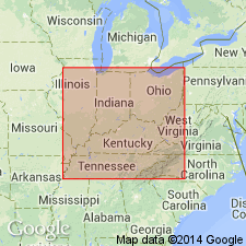
- Illinois basin
- Cincinnati arch
Summary:
The age of the Blocher Member of the New Albany Shale in IN is changed to Late Devonian. Conodont biostratigraphy indicates that the Blocher is of Frasnian age as evidenced by conodonts of the TRANSITANS and PUNCTATA zones. The lower part of the Blocher is equivalent to the Squaw Bay Limestone [See Note Below] of the Michigan basin. Unit unconformably overlies the Beechwood Member of the North Vernon Limestone and underlies the Selmier Member of the New Albany.
[NOTE: In accordance with Department of Interior's Secretarial Order 3404, discontinuing use of derogatory term squaw, the Squaw Bay Limestone is in process of being formally renamed Birdsong Bay Limestone (RESERVED). The geographic feature Squaw Bay, from which the geologic name was taken (Warthin and Cooper, 1935), was renamed Birdsong Bay by U.S. Board on Geographic Names, September 2022, USGS GNIS FeatureID 638662.]
Source: GNU records (USGS DDS-6; Reston GNULEX).
For more information, please contact Nancy Stamm, Geologic Names Committee Secretary.
Asterisk (*) indicates published by U.S. Geological Survey authors.
"No current usage" (†) implies that a name has been abandoned or has fallen into disuse. Former usage and, if known, replacement name given in parentheses ( ).
Slash (/) indicates name conflicts with nomenclatural guidelines (CSN, 1933; ACSN, 1961, 1970; NACSN, 1983, 2005, 2021). May be explained within brackets ([ ]).