The National Geologic Map Database is migrating to a new infrastructure. We apologize for any service disruptions during this process.
|
|---|


- Usage in publication:
-
- Black Canyon schist*
- Modifications:
-
- Original reference
- Dominant lithology:
-
- Schist
- Gneiss
- Amphibolite
- AAPG geologic province:
-
- Southern Rocky Mountain region
Summary:
Black Canyon schist. Schists and gneisses of metamorphic complex of Gunnison River region, central western Colorado, which show great diversity in composition and texture, including all gradations from biotite schist, quartz-muscovite schist, and granite gneiss to chlorite and amphibole schists and even to amphibolite. The commonest and fundamental rock is biotite schist. The rocks range from black to gray; weathering may give them brownish or yellowish tones, and abundant microcline may add a slight pinkish tint. Most of rocks are well laminated. Occurs throughout area, with many interruptions, from Cochetopa Creek down the Gunnison nearly to mouth of Smiths Fork. Save for the many bodies of igneous rocks that have invaded it and the River Portal schist which might be regarded as a part of it and which extends from a point east of Camarron to north end of Vernal Mesa, the pre-Cambrian area adjacent to Gunnison River is composed almost entirely of Black Canyon schist. May be older than River Portal mica schist. Age is pre-Cambrian.
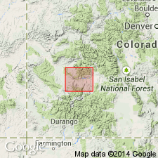
Best and most accesible exposures are in walls of Black Canyon from Sapinero to the Curecanti granite and up Lake Fork Canyon to granite mass 1 mi above Vanguard [no longer exists; was about 10 mi northwest of Powderhorn, in center of N/2 sec. 32, T. 48 N.,R. 3 W., approx. Lat. 38 deg. 22 min. 13 sec. N., Long. 107 deg. 14 min. 09 sec. W., Gateview 7.5-min quadrangle, Gunnison Co., central western CO]. Named from Black Canyon of Gunnison River, Montrose Co., central western CO.
[GNC remark (ca. 1936, US geologic names lexicon, USGS Bull. 896, p. 199): On 1935 Colorado geologic map this formation was assigned to Gunnison River series, which includes all of oldest exposed rocks in Colorado.]
Source: US geologic names lexicon (USGS Bull. 896, p. 199); supplemental information from GNU records (USGS DDS-6; Denver GNULEX).
- Usage in publication:
-
- Black Canyon Schist*
- Modifications:
-
- Areal extent
- AAPG geologic province:
-
- Southern Rocky Mountain region
Summary:
Pg. D2 (fig. 1), D4 (table 1). Black Canyon Schist. Recognized on Gunnison River, southwestern Colorado. In very limited use. Impractically distinguished from River Portal Mica Schist. Age is Precambrian X.
(See Hansen, 1971, USGS Misc. Geol. Inv. Map I-584; Olson and Hedlund, 1973, USGS Geol. Quad. Map GQ-1071 [1974].)
Source: Publication.
For more information, please contact Nancy Stamm, Geologic Names Committee Secretary.
Asterisk (*) indicates published by U.S. Geological Survey authors.
"No current usage" (†) implies that a name has been abandoned or has fallen into disuse. Former usage and, if known, replacement name given in parentheses ( ).
Slash (/) indicates name conflicts with nomenclatural guidelines (CSN, 1933; ACSN, 1961, 1970; NACSN, 1983, 2005, 2021). May be explained within brackets ([ ]).