

- Usage in publication:
-
- Big Horse Limestone Member
- Modifications:
-
- Overview
- AAPG geologic province:
-
- Great Basin province
Summary:
Big Horse Limestone Member of Orr Formation. Shown on correlation chart. Age is Late Cambrian (Dresbachian).
Source: Modified from GNU records (USGS DDS-6; Menlo GNULEX).
- Usage in publication:
-
- Big Horse Limestone Member*
- Modifications:
-
- Principal reference
- Dominant lithology:
-
- Limestone
- AAPG geologic province:
-
- Great Basin province
Summary:
Pg. G4-G5, G12 (fig. 4), G15-G18, G19 (fig. 5), G21+. Big Horse Limestone Member of Orr Formation. Ledge-forming, medium- to dark-gray calcarenite and massive stromatolitic limestone. Thickness 715 feet (217.9 m) at type, 700 feet (213 m) at reference section. At type, overlies Weeks Limestone and underlies Candland Shale Member of Orr Formation. In Wah Wah Mountains, overlies Wah Wah Summit Formation and underlies Steamboat Pass Shale Member of Orr Formation. Correlates with parts of: Straight Canyon Formation of Dugway Range, Utah; Hicks Formation of Deep Creek Range, Utah; and Opex Formation of East Tintic Mountains, Utah. Also correlates with Lincoln Peak Formation of southern Snake Range, Nevada. Fossils [listed]; contains specimens representative of CEDARIA and CREPICEPHALUS trilobite assemblage zones. Age is Late Cambrian, based on fossils.
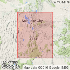
Type section (=type section of Orr Formation): composite of two measured sections on northeast side of Orr Ridge, House Range, Millard Co., UT. Lower part on northeast face of hill 6593, northeast side of Orr Ridge, from about 6,200 to 6,500+ ft. elev., in SE/4 sec. 28 [unsurveyed], T. 18 S., R. 13 W., [approx. Lat. 39 deg. 12 min. 41 sec. N., Long. 113 deg. 18 min. 30 sec. W.], and remainder about 0.5 mi south, along crest of ridge between Little Horse Canyon and Big Horse Canyon, from about 6,400 to 7,000 ft. elev., in SW/4 SE/4 NE/4 sec. 33 [unsurveyed], T. 18 S., R. 13 W., [approx. Lat. 39 deg. 12 min. 06 sec. N., Long. 113 deg. 18 min. 42 sec. W.], Notch Peak 15-min quadrangle, House Range, Millard Co., west-central UT.
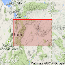
Reference section (=reference section of Orr Formation): about 0.5 mi south of Lawson Cove Reservoir on east side of Hill 6190, in SW/4 sec. 29, T. 24 S., R. 14 W., [approx. Lat. 38 deg. 41 min. 24 sec. N., Long. 113 deg. 26 min. 52 sec. W.], northern Wah Wah Mountains, Frisco Peak 15-min quadrangle (1960), Millard Co., west-central UT.
Named from exposures in Big Horse Canyon, House Range, Millard Co., west-central UT.
Recognized in House, Fish Springs, Cricket, Wah Wah Mountains, and Deep Creek Ranges.
[Additional locality information from USGS historical topographic map collection TopoView, accessed Memorial Day 2018.]
Source: Publication; US geologic names lexicon (USGS Bull. 1564, p. 13).
- Usage in publication:
-
- Big Horse Limestone*
- Modifications:
-
- Revised
- Areal extent
- AAPG geologic province:
-
- Great Basin province
Summary:
Big Horse Limestone. A dark-gray, thin-bedded, silty, oolitic limestone. Lower part is well-layered and silty; upper part is medium-bedded to massive. Forms cliffs and steep slopes. Thickness 600 feet (180 m). Age is Cambrian.
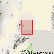
Rank raised [locally] on Crater Island, western edge of Lucin 4 SW 7.5-min quadrangle, Box Elder County, Utah.
Source: Publication; supplemental information from GNU records (USGS DDS-6; Menlo GNULEX).
- Usage in publication:
-
- Big Horse Limestone Member*
- Modifications:
-
- Areal extent
- AAPG geologic province:
-
- Great Basin province
Miller, J.F., Evans, K.R., and Dattilo, B.F., 2012, The great American carbonate bank in the miogeocline of western central Utah; Tectonic influences on sedimentation; Chapter 31: American Association of Petroleum Geologists Memoir, 98, p. 769-854.
Summary:
Pg. 780 (fig. 13), 781, 784, 792-794, 796 (figs.). Big Horse Limestone Member of Orr Formation. Massive cliff-forming limestones. Consists of cyclic alternations of shallow high-energy deposits interbedded with deeper low-energy deposits. Shallow high-energy deposits include ooid grainstones, skeletal and oncoid grainstones, thrombolite and stromatolite biostromes, and patch reefs. A widespread light-gray stromatolitic boundstone occurs at top of member in Steamboat Pass area, southern House Range, and in northern Wah Wah Mountains. Deeper low-energy deposits include burrowed, laminated, and nodular limestones. Thickness 715 feet (218 m) in Orr Ridge area, central House Range; 660 feet (201 m) in Cricket Mountains; 700 feet (213 m) in Wah Wah Mountains. Is basal member of Orr Formation, underlies Candland Shale Member, or where absent, Steamboat Pass Shale Member. Overlies Weeks Limestone in central part of House Range, and white marker member of Wah Wah Summit Formation in southern House Range. Fossils. Lies within the CEDARIA and CREPICEPHALUS trilobite assemblage zones (Hintze and Palmer, 1976). Is top unit of Middle Cambrian provincial Laurentian Marjuman Stage of the Lincolnian Series (A.R. Palmer, 1998, Canadian Jour. Earth Sci., v. 35, p. 323-328). [See also J.F. Taylor and others, Chap. 3, this vol., and references therein.] Age is latest Middle Cambrian.
Source: Publication.
For more information, please contact Nancy Stamm, Geologic Names Committee Secretary.
Asterisk (*) indicates published by U.S. Geological Survey authors.
"No current usage" (†) implies that a name has been abandoned or has fallen into disuse. Former usage and, if known, replacement name given in parentheses ( ).
Slash (/) indicates name conflicts with nomenclatural guidelines (CSN, 1933; ACSN, 1961, 1970; NACSN, 1983, 2005, 2021). May be explained within brackets ([ ]).