

- Usage in publication:
-
- Beacon Peak dolomite member*
- Modifications:
-
- Original reference
- Dominant lithology:
-
- Dolomite
- AAPG geologic province:
-
- Great Basin province
Summary:
Pg. 41, 42, pls. 1, 2. Beacon Peak dolomite member of Nevada formation. Composed of beds of dense, sometimes porcellaneous, light-olive-gray to slightly brownish creamy-gray dolomite that weathers to a pale gray to white and has a faint blue tinge; this contrasts with yellow tint of Lone Mountain dolomite. Some is clastic in origin. Individual beds probably average a foot in thickness. A number of thin brown-weathering sandstone interbeds in upper half of member. Thickness 470 to 940 feet, the larger thickness being to the north. Unconformably[?] overlies Lone Mountain dolomite and is rather sharply gradational with overlying Oxyoke Canyon sandstone member (new) of Nevada formation. Is basal member of Nevada formation. Recognized in Diamond Mountains. Not known to be present west of Eureka. Age is Early Devonian.
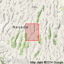
Type locality: in Oxyoke Canyon, on lower western slope of Beacon Peak, [in W/2 sec. 16 and E/2 sec. 17, T. 18 N., R. 54 E., approx. Lat. 39 deg. 25 min. 50 sec. N., Long. 115 deg. 54 min. 26 sec. W., Pinto Summit 15-min quadrangle, White Pine-Eureka Co. line, central NV].
[Additional locality information from USGS GNIS database and USGS historical topographic map collection TopoView, accessed Memorial Day, 2018.]
Source: US geologic names lexicon (USGS Bull. 1200, p. 247); supplemental information from GNU records (USGS DDS-6; Menlo GNULEX).
- Usage in publication:
-
- Beacon Peak Dolomite*
- Modifications:
-
- Revised
- Biostratigraphic dating
- AAPG geologic province:
-
- Great Basin province
Summary:
Beacon Peak Dolomite Member of Nolan and others (1958) raised in rank to Beacon Peak Dolomite. †Nevada Formation abandoned (its members raised to formation rank). Unit conformably underlies McColley Canyon Formation in northern Antelope Range. Conodonts from 65 and 130 m below top of unit indicate age from very latest Silurian to Early Devonian. Shown on stratigraphic column as Early Devonian.
Source: Modified from GNU records (USGS DDS-6; Menlo GNULEX).
For more information, please contact Nancy Stamm, Geologic Names Committee Secretary.
Asterisk (*) indicates published by U.S. Geological Survey authors.
"No current usage" (†) implies that a name has been abandoned or has fallen into disuse. Former usage and, if known, replacement name given in parentheses ( ).
Slash (/) indicates name conflicts with nomenclatural guidelines (CSN, 1933; ACSN, 1961, 1970; NACSN, 1983, 2005, 2021). May be explained within brackets ([ ]).