

- Usage in publication:
-
- Battle Spring formation*
- Modifications:
-
- Original reference
- Dominant lithology:
-
- Sandstone
- Claystone
- AAPG geologic province:
-
- Green River basin
Summary:
Pg. 101 (chart), 103. Battle Spring formation. Very coarse-grained to pebbly arkosic sandstone with small amounts of bright-green claystone that contains abundant large angular grains of clear quartz. Sandstone cross-bedded. Inferred thickness about 3,300 feet but probably is greater. Unconformably overlies Fort Union formation; partly underlies and intertongues with Morrow Creek member of Green River formation. Intertongues to the south with Red Desert (new), Niland (new), and Cathedral Bluffs tongues of Wasatch formation; and with Luman (new) and Tipton tongues of Green River formation. Age is early and middle Eocene.
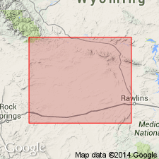
Typical exposures southwest of Battle Spring Flat [in T. 23 and 24 N., R. 94 W.], and southeast of Lost Creek Butte, [in T. 23 N., R. 95 W.], Sweetwater Co., southwestern WY. Underlies most of eastern part of Great Divide basin. Base of formation exposed on north slope of Flattop Buttes and at a point about 10 mi west of Rawlins in northwestern part of T. 21 N., R. 89 W., southwestern WY.
Type area: in SW/4 T. 23 N., R. 94 W., about 20 mi north of station of Frewen on Union Pacific RR, eastern Sweetwater Co., WY (GNC index card files).
Source: US geologic names lexicon (USGS Bull. 1200, p. 240).
- Usage in publication:
-
- Battle Spring formation*
- Modifications:
-
- Overview
- AAPG geologic province:
-
- Green River basin
Summary:
Described in the Red Desert area, Sweetwater Co, WY, Greater Green River basin, with main body of Wasatch formation. Name Battle Spring formation used reluctantly. Rocks called Battle Spring formation are a mountainward fluviatile facies of the Wasatch formation that grade into fine-grained thin-bedded coal, shale, and sandstone facies basinward that represent lake, swamp, and stream environments. Also, the name Battle Spring was not well defined having no type, top, or bottom. Age range uncertain--may be early, middle and late Eocene.
Source: GNU records (USGS DDS-6; Denver GNULEX).
- Usage in publication:
-
- Battle Spring Formation*
- Modifications:
-
- Age modified
- AAPG geologic province:
-
- Wind River basin
- Green River basin
Summary:
Described with Wasatch Formation and not as a separate unit. Author agrees with Masursky (1962) that the name Battle Spring Formation is undesirable because it is just a "mountainward fluviatile facies of the main body of the Wasatch formation." Map unit Wasatch and Battle Spring Formations shown in south-central part of map area in Great Divide basin into Fremont Co, WY in the Wind River basin as well as Sweetwater Co, WY in the Greater Green River basin. Formations lie south of the Granite Mountains fault. Geologic map. Cross sections. The coarse white to tan sandstone [the Battle Spring of Pipiringos, 1955] is well described. Carbonized wood and leaf fragments common. No bones or invertebrate fossils found. Paleocene pollen found in one well indicate the lower part of the Battle Spring and Wasatch sequence is Paleocene, thus modifying the lower age limit.
Source: GNU records (USGS DDS-6; Denver GNULEX).
- Usage in publication:
-
- Battle Spring Formation*
- Modifications:
-
- Overview
- AAPG geologic province:
-
- Green River basin
- Wind River basin
Summary:
Mapped on south and west side of quad in Sweetwater Co, WY in the Greater Green River basin, and Fremont Co, WY in the Wind River basin. Divided into two major map units. Lower part of yellow-gray arkose and conglomeratic arkose with interbedded gray arkosic mudstone that are generally poorly indurated, 580-625 m thick. Upper part of green-gray mudstone and brownish carbonaceous mudstone, yellow-gray conglomeratic arkose and conglomerate, interbedded with giant conglomerate, 580-625 m thick. Lower part divided into 3 mapped units. Lower part correlated in part with main body of Wasatch Formation. Upper part correlated with Crooks Gap Conglomerate that is divisible into three mapped units in the northeast part of quad. Of middle and early Eocene age.
Source: GNU records (USGS DDS-6; Denver GNULEX).
For more information, please contact Nancy Stamm, Geologic Names Committee Secretary.
Asterisk (*) indicates published by U.S. Geological Survey authors.
"No current usage" (†) implies that a name has been abandoned or has fallen into disuse. Former usage and, if known, replacement name given in parentheses ( ).
Slash (/) indicates name conflicts with nomenclatural guidelines (CSN, 1933; ACSN, 1961, 1970; NACSN, 1983, 2005, 2021). May be explained within brackets ([ ]).