

- Usage in publication:
-
- Barlow Cove formation*
- Modifications:
-
- Original reference
- Dominant lithology:
-
- Schist
- Andesite
- Conglomerate
- Graywacke
- AAPG geologic province:
-
- Alaska Southeastern region
Summary:
Barlow Cove formation. Largely chlorite-epidote-albite schist with minor amounts of augite-bearing volcanic flow breccia, andesite, quartz-pebble graywacke conglomerate, laminated massive homogenous graywacke, and black slate. Well-defined member of chlorite-epidote-albite schist, slate, graywacke, and quartz-pebble conglomerate, approximately 300 to 800 feet thick, extends from Barlow Cove to Lone Mountain and delineates Lone Mountain fold. Total thickness approximately 6,500 feet without allowance for repetition by minor folds. Appears to be in contact with Retreat group (new) along bedding fault. Underlies Symonds formation (new). Flows probably were deposited simultaneously with flow breccias of Jurassic(?) to Lower Cretaceous(?) Douglas Island volcanic group. Age is thus probably Jurassic(?) to Early Cretaceous(?).
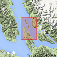
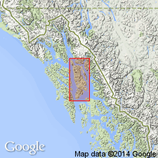
Type locality: along eastern shore of Barlow Cove, Juneau B-3 quadrangle (scale 1:63,360), Admiralty Island, southeastern AK. Extends from south boundary of quad northward to Barlow Point and Hump Island.
[GNC remark (ca. 1960, US geologic names lexicon, USGS Bull. 1200, p. 215): USGS currently designates the age of the Barlow Cove Formation as Permian and Triassic(?) on basis of study now in progress. See entry under Lathram and others (1960).]
Source: US geologic names lexicon (USGS Bull. 1200, p. 215); GNU records (USGS DDS-6; Menlo GNULEX).
- Usage in publication:
-
- Barlow Cove formation*
- Modifications:
-
- Age modified
- AAPG geologic province:
-
- Alaska Southeastern region
Summary:
Barlow Cove formation of Barker (1957) is correlative with rock unit south of Young Bay which contain MUIRWOODIA (identified by G.A. Cooper, 1957) of probable Permian age and fossils of possible Late Triassic age (J.T. Dutro, Jr., written commun, 1958). "In this report [unit is] considered Permian and (or) Triassic in age." Map legend shows age to be Permian and Triassic(?).
Source: GNU records (USGS DDS-6; Menlo GNULEX).
For more information, please contact Nancy Stamm, Geologic Names Committee Secretary.
Asterisk (*) indicates published by U.S. Geological Survey authors.
"No current usage" (†) implies that a name has been abandoned or has fallen into disuse. Former usage and, if known, replacement name given in parentheses ( ).
Slash (/) indicates name conflicts with nomenclatural guidelines (CSN, 1933; ACSN, 1961, 1970; NACSN, 1983, 2005, 2021). May be explained within brackets ([ ]).