

- Usage in publication:
-
- Athens shale*
- Modifications:
-
- Original reference
- Dominant lithology:
-
- Shale
- AAPG geologic province:
-
- Appalachian basin
Summary:
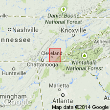
Pg. 2. Athens shale. East of Tennessee River the upper part of Chickamauga limestone is replaced by calcareous shales weathering yellow, from 300 to 500 feet thick. Eastward beyond edge of this sheet this formation increases to several thousand feet, where the strata represent the rapid and variable accumulation of sediment near the shore. Underlies Rockwood formation and rests on a part of Chickamauga limestone. [Age is Early Ordovician.]
[The area here described adjoins type locality.]
Source: US geologic names lexicon (USGS Bull. 896, p. 86).
- Usage in publication:
-
- Athens shale*
- Modifications:
-
- Areal extent
- AAPG geologic province:
-
- Appalachian basin
Summary:
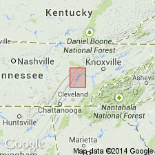
Pg. 3. Athens shale. In belt extending from northeastern corner of Cleveland tract toward southwest, across Hiwassee River, a part of Chickamauga limestone is replaced by Athens shale, from 850 to 1,100 feet thick, in some places sandy, but generally calcareous, dark blue when fresh, but weathering yellow. Increases in tickness to 2,500 or 3,000 feet along east side of valley, and includes a bed of calcareous sandstone 250 to 700 feet thick about 500 feet above base. [In columnar section of this folio this sandstone is called Athens sandstone.] Underlies Tellico sandstone and overlies part of Chickamauga limestone. [Age is Early Ordovician.]
[This area includes type locality.]
Source: US geologic names lexicon (USGS Bull. 896, p. 86).

- Usage in publication:
-
- Athens shale*
- Modifications:
-
- Overview
- AAPG geologic province:
-
- Appalachian basin
Summary:
Athens shale of Blount group. Age is Early Ordovician. Named from exposures at Athens, McMinn Co., eastern TN. Extends into northern AL, western NC, and western VA.
The commonly accepted definition of Athens shale in Tennessee applies to beds underlying Tellico sandstone and overlying Holston marble, but Ulrich (1929) defined it as overlying his newly proposed Whitesburg limestone, which he stated in places intervenes between Athens shale and Holston marble. Fauna is considered to be of Normanskill age. In northern Alabama C. Butts (Alabama Geol. Survey Spec. Rept., no. 14, 1926) identified Athens shale as underlying Little Oak limestone and overlying Lenoir limestone. Based upon work of C. Butts in Appalachian Valley of Virginia, the USGS now uses Athens shale (or Athens limestone, where the formation becomes so calcareous as to be a limestone) across Appalachian Valley of Virginia, from Tennessee to West Virginia line. This use of Athens limestone displaces the local name Liberty Hall limestone.
Source: US geologic names lexicon (USGS Bull. 896, p. 86).
- Usage in publication:
-
- Athens formation
- Modifications:
-
- Age modified
- Redescribed
- Dominant lithology:
-
- Shale
- Limestone
- Sandstone
- AAPG geologic province:
-
- Appalachian basin
Summary:
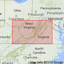
The Athens formation in VA has three distinct facies of gray to black shale, sandstone, and limestone. Thickness varies from a few feet on western margins to perhaps 5000 to 10,000 feet in large area in southern Washington Co., VA and northern Sullivan Co., TN. In all areas in VA where the Holston limestone and Athens are both present, the Athens overlies the Whitesburg limestone, however, in places the unit locally overlies the Lenoir limestone. In Rich Valley the Athens underlies the Ottosee limestone, in Shenandoah, Rockingham, Montgomery, and Pulaski Cos. it underlies the Chambersburg limestone, and in some areas it underlies the Lowville Moccasin formation. Fossil evidence and stratigraphic position demonstrates that the Athens is of Middle Ordovician (Chazyan) age.
Source: GNU records (USGS DDS-6; Reston GNULEX).
- Usage in publication:
-
- Athens
- Modifications:
-
- Not used
- AAPG geologic province:
-
- Appalachian basin
Summary:
In author's discussion of the Middle Ordovician of the Tellico-Sevier belt of eastern TN, the lower part of the Athens shale is revised to its own formation, the Blockhouse shale, and the upper part of the Athens is called to Tellico formation. It is proposed that the terms Ottosee shale, Holston formation and Athens shale not be used because they are time stratigraphic units.
Source: GNU records (USGS DDS-6; Reston GNULEX).
- Usage in publication:
-
- Athens formation
- Modifications:
-
- Revised
- Areal extent
- Biostratigraphic dating
- AAPG geologic province:
-
- Appalachian basin
Summary:
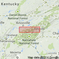
Pg. 43-45, chart 1 (facing p. 130). Athens formation. Restricted to type area where it is mostly silty or sandy, cobbly limestone that weathers to a yellow sandy, shaly rock; at type section, contains a small amount of shale near base. Is equivalent or partly equivalent to Farragut, Arline, Paperville, Blockhouse, and Toqua formations. Underlies Red Knobs formation. Is separated from underlying Lenoir limestone by thin basal tongue (the Fetzer) of Arline formation. Fossils [listed and described], notably brachiopods ATELELASMA, CHRISTIANIA, ISOPHRAGMA, PAURORTHIS, and TITANAMBONITES. Age is considered Porterfield stage (new, see p. 8); Bolarian of Kay, 1948 (AAPG Bull., v. 32, no. 8, p. 1402); [Middle Ordovician (Black River) of Twenhofel and others, 1954, GSA Bull., v. 65, p. 247-298].
Superb 170 ft-thick section along road parallel to Hiwasee River, 2 to 3 mi southeast of Charleston.
Source: Publication.
- Usage in publication:
-
- Athens shale
- Modifications:
-
- Areal extent
- AAPG geologic province:
-
- Appalachian basin
Summary:
The Athens shale in the Cohutta Mountain quadrangle is present in a belt running diagonally across the northwestern corner of the area. It consists of calcareous silty shale and calcareous siltstone with minor amounts of interbedded calcareous feldspathic sandstone (concentrated in lower half of formation. Thickness is about 4000 feet. Unit overlies the Newala limestone and underlies the Chota formation.
Source: GNU records (USGS DDS-6; Reston GNULEX).

- Usage in publication:
-
- Athens shale
- Modifications:
-
- Overview
- AAPG geologic province:
-
- Appalachian basin
Summary:
Pg. 23, plate in pocket. Athens Shale. Present in the eastern Valley and Ridge province, Alabama, primarily in the southwestern part. Consists of black graptolitic fissile shale, which in its lower part contains interbeds of argillaceous dark-gray to black limestone. Thickness 0 to 300 feet. To the northeast, grades into the Little Oak Limestone and the Lenoir Limestone. Age is Middle Ordovician (Chazyan-Porterfieldian).
Source: Publication; GNU records (USGS DDS-6; Reston GNULEX).
For more information, please contact Nancy Stamm, Geologic Names Committee Secretary.
Asterisk (*) indicates published by U.S. Geological Survey authors.
"No current usage" (†) implies that a name has been abandoned or has fallen into disuse. Former usage and, if known, replacement name given in parentheses ( ).
Slash (/) indicates name conflicts with nomenclatural guidelines (CSN, 1933; ACSN, 1961, 1970; NACSN, 1983, 2005, 2021). May be explained within brackets ([ ]).