The National Geologic Map Database is migrating to a new infrastructure. We apologize for any service disruptions during this process.
|
|---|


- Usage in publication:
-
- Aromas red sands
- Modifications:
-
- Original reference
- Dominant lithology:
-
- Sandstone
- AAPG geologic province:
-
- Northern Coast Range province
Summary:
Pg. 18 (fig. 2), 43-45, pls. 1, 2, 3. Aromas red sands. Dark-brown to red friable quartzose sandstone which disintegrates easily. Thickness from 600 to 800 feet; 180 feet at type section. Underlie terrace gravels and alluvium. Unconformably overlie all older formations with which they are in contact, successively overlapping upon Santa Lucia granite, San Lorenzo, Vaqueros, volcanics, and Pliocene rocks [Purisima formation]. [Also overlie Monterey shale and Merced formation.] Age is believed to be at least middle(?) Pleistocene, based on stratigraphic relations (no fossil evidence).
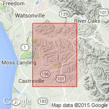
Type section: in railroad cut 1 mi west of town of Aromas [in T. 12 S., R. 3 E., Lat. 36 deg. 54 min. N., Long. 121 deg. 39 min. W., Watsonville East 7.5-min quadrangle, Monterey Co., CA]. Occurs in most of southwest quarter of San Juan Bautista 15-min quadrangle.
Source: US geologic names lexicon (USGS Bull. 1200, p. 140); GNU records (USGS DDS-6; Menlo GNULEX).
- Usage in publication:
-
- Aromas Sand*
- Modifications:
-
- Adopted
- Redescribed
- Dominant lithology:
-
- Sand
- AAPG geologic province:
-
- Northern Coast Range province
Summary:
Aromas Red Sands of Allen (1946) and Bowen (AAPG Pac. Sec. 40th Ann. Mtg., Bakersfield, CA, p. 48-67, 1965; abs., AAPG Bull., v. 49, no. 7, p. 1081, 1965) adopted by the USGS as Aromas Sand. Described as nonmarine, yellowish-brown to grayish-orange fine sand. Unconformably(?) overlies Paso Robles Formation; unconformably underlies Pleistocene older surficial sediments. Age is Pleistocene.
Source: Changes in stratigraphic nomenclature, 1974 (USGS Bull. 1405-A, p. A2-A3); GNU records (USGS DDS-6; Menlo GNULEX).
For more information, please contact Nancy Stamm, Geologic Names Committee Secretary.
Asterisk (*) indicates published by U.S. Geological Survey authors.
"No current usage" (†) implies that a name has been abandoned or has fallen into disuse. Former usage and, if known, replacement name given in parentheses ( ).
Slash (/) indicates name conflicts with nomenclatural guidelines (CSN, 1933; ACSN, 1961, 1970; NACSN, 1983, 2005, 2021). May be explained within brackets ([ ]).